THIS AVALANCHE FORECAST EXPIRED ON March 14, 2019 @ 6:50 am
Avalanche Forecast published on March 13, 2019 @ 6:50 am
Issued by Steve Reynaud - Tahoe National Forest

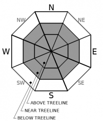
MODERATE avalanche danger will continue due to a wind slab avalanche problem in near and above treeline areas.  LOW avalanche danger exists in below treeline terrain.

2. Moderate

?

Above Treeline
Heightened avalanche conditions on specific terrain features. Evaluate snow and terrain carefully; identify features of concern.

2. Moderate

?

Near Treeline
Heightened avalanche conditions on specific terrain features. Evaluate snow and terrain carefully; identify features of concern.

1. Low

?

Below Treeline
Generally safe avalanche conditions. Watch for unstable snow on isolated terrain features.
    Heightened avalanche conditions on specific terrain features. Evaluate snow and terrain carefully; identify features of concern.
Avalanche Problem 1: Wind Slab
  • Type ?
  • Aspect/Elevation ?
  • Likelihood ?
    Certain
    Very Likely
    Likely
    Possible
    Unlikely
  • Size ?
    Historic
    Very Large
    Large
    Small

Changing wind directions over this past week along with available snow for transport has created wind slabs on many aspects in near and above treeline terrain.  After strong SW winds yesterday, winds shifted to the NE last night and will be in the strong to gale force range transporting snow today.  Lingering wind slabs could still be reactive along with newly developing wind slabs.  Multiple user triggered wind slab avalanches have occurred over the last 4 days.

All near and above treeline avalanche terrain that is not thoroughly wind scoured should be suspect for potential wind slabs.  Blowing snow, wind pillows, and new cornice development will give you clues as to where new wind slabs may exist.  Stubborn wind slabs may have hard slab characteristics.  Softer snow will exist in wind protected below treeline terrain away from the wind slab avalanche problem.  

Forecast discussion

Minor amounts of snow surface warming may occur today in sun exposed areas at low to mid elevations.  Below average temperatures along with strong to gale force NE winds are expected to limit snow surface warming and keep a loose wet avalanche problem from forming today.

recent observations

*  Human triggered wind slab avalanches up to size D2 have been reported every day since Saturday in near to above treeline areas.  Snowpack tests and informal observations continue to show wind slab instabilities in many areas.

*  Strong SW winds with intense blowing snow was observed throughout the forecast area yesterday.

* A variety of snow surface crusts are forming on southerly aspects.

Weather and CURRENT CONDITIONS
weather summary

1 to 4'' of new snowfall was reported from remote sensors yesterday afternoon into the evening.  A cool and brisk day is forecasted with temperatures 5 to 10 degrees below normal for this time of year.  NE winds along ridges are currently in the 35 to 45mph range with gusts possible up to 70mph today.  High pressure builds into the area on Thursday with decreasing winds and increasing temperatures.  This weekend looks to be warmer with dry conditions.


CONDITIONS ALONG THE SIERRA CREST BETWEEN 8200 FT. AND 9200 FT. IN THE LAST 24 HOURS
6am temperature: 8 to 14 deg. F.
Max. temperature: 36 deg. F.
Average ridgetop wind direction: W shifting to NE
Average ridgetop wind speed: 35 to 45 mph
Maximum ridgetop wind gust: 107 mph
New snowfall: 1 to 4 inches
Total snow depth: 125 to 135 inches
Two-Day Mountain Weather Forecast Produced in partnership with the Reno NWS
For 7000 ft. to 8000 ft.
Wednesday Wednesday Night Thursday
Weather: Sunny. Snow levels below 7000 feet. Chance of precipitation is 0%. Clear. Snow levels below 7000 feet. Chance of precipitation is 0%. Sunny then becoming partly cloudy. Snow levels below 7000 feet. Chance of precipitation is 0%.
Temperatures: 29 to 34. deg. F. 10 to 16. deg. F. 35 to 41. deg. F.
Mid Slope Winds: Light winds becoming northeast around 15 mph in the afternoon. Gusts up to 25 mph. Northeast around 15 mph in the evening becoming light. Gusts up to 25 mph. Light winds.
Expected snowfall: No accumulation. | SWE = none. No accumulation. | SWE = none. No accumulation. | SWE = none.
For 8000 ft. to 9000 ft.
Wednesday Wednesday Night Thursday
Weather: Sunny. Snow levels below 7000 feet. Chance of precipitation is 0%. Clear. Snow levels below 7000 feet. Chance of precipitation is 0%. Sunny then becoming partly cloudy. Snow levels below 7000 feet. Chance of precipitation is 0%.
Temperatures: 24 to 30. deg. F. 9 to 14. deg. F. 30 to 36. deg. F.
Ridge Top Winds: Northeast 15 to 30 mph increasing to 25 to 35 mph in the afternoon. Gusts up to 70 mph. East 15 to 30 mph. Gusts up to 60 mph decreasing to 45 mph after midnight. East around 15 mph with gusts to 30 mph.
Expected snowfall: No accumulation. | SWE = none. No accumulation. | SWE = none. No accumulation. | SWE = none.
Disclaimer

This avalanche forecast is provided through a partnership between the Tahoe National Forest and the Sierra Avalanche Center. This forecast covers the Central Sierra Nevada Mountains between Yuba Pass on the north and Ebbetts Pass on the south. Click here for a map of the forecast area. This forecast applies only to backcountry areas outside established ski area boundaries. This forecast describes general avalanche conditions and local variations always occur. This forecast expires 24 hours after the posted time unless otherwise noted. The information in this forecast is provided by the USDA Forest Service who is solely responsible for its content.

For a recorded version of the avalanche forecast call (530) 587-3558 x258