THIS AVALANCHE FORECAST EXPIRED ON March 15, 2019 @ 6:58 am
Avalanche Forecast published on March 14, 2019 @ 6:58 am
Issued by Andy Anderson - Tahoe National Forest - Sierra Avalanche Center

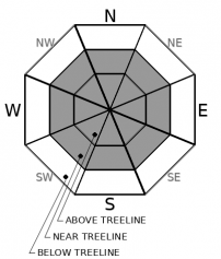
MODERATE avalanche danger exists at all elevations today. Wind slab and loose wet avalanche problems are possible. Either of these problems could have consequences for backcountry travelers.

2. Moderate

?

Above Treeline
Heightened avalanche conditions on specific terrain features. Evaluate snow and terrain carefully; identify features of concern.

2. Moderate

?

Near Treeline
Heightened avalanche conditions on specific terrain features. Evaluate snow and terrain carefully; identify features of concern.

2. Moderate

?

Below Treeline
Heightened avalanche conditions on specific terrain features. Evaluate snow and terrain carefully; identify features of concern.
    Heightened avalanche conditions on specific terrain features. Evaluate snow and terrain carefully; identify features of concern.
Avalanche Problem 1: Wind Slab
  • Type ?
  • Aspect/Elevation ?
  • Likelihood ?
    Certain
    Very Likely
    Likely
    Possible
    Unlikely
  • Size ?
    Historic
    Very Large
    Large
    Small

Blowing snow and shifting winds mean that slabs of wind drifted snow could exist on almost any wind-exposed aspect. Newer wind slabs will exist on slopes loaded by the NE winds. Older more difficult to trigger wind slabs may still linger on slopes loaded by SW winds. Some human-triggered wind slab avalanches large enough to bury injure or kill a person may remain possible today. Complex or extreme terrain including couloirs, cliffy areas, unsupported slopes, and steep convex rollovers will be the most suspect. Large cornices also still exist along the ridgelines.

Cornices, blowing snow, drifted snow, firm hollow sounding snow, and other wind created surface textures can help identify where wind slabs may exist. These areas will also have more challenging snow conditions including scoured surfaces, sastrugi, and firm wind-packed snow. Seeking out more sheltered terrain will provide softer more consistent snow with fewer avalanche concerns.

Avalanche Problem 2: Loose Wet
  • Type ?
  • Aspect/Elevation ?
  • Likelihood ?
    Certain
    Very Likely
    Likely
    Possible
    Unlikely
  • Size ?
    Historic
    Very Large
    Large
    Small

Strong March sunshine and warmer daytime temperatures may cause enough warming for wet snow to form on sun-exposed slopes despite the cool NE winds. Loose wet instabilities like roller balls, pinwheels, and loose wet avalanches will be possible today. Some of these will remain small. Some of them could entrain enough snow to have consequences for backcountry travelers especially on long, steep, sun-exposed slopes or in areas where terrain traps increase the severity of an avalanche.

Wet surface snow, small pinwheels, and roller balls can foreshadow larger loose wet avalanches. Expect wet sticky snow and variable sun crusts in addition to more loose wet avalanche concerns on sun-exposed slopes. Moving to more shaded and sheltered northerly aspects can help find colder soft snow and reduce exposure to avalanche concerns.

recent observations

* Yesterday plumes of blowing snow could be seen all along the Sierra Crest and in the Carson Range as the NE winds moved snow across the ridgelines. 

* Observations near Carson Pass found wind affected snow surfaces on all aspects near ridgelines with a mix of scoured surfaces, sastrugi, and firm wind slabs present. 

* Observations on sheltered northerly aspects near Carson Pass did not find any signs of instability. These areas still held soft cold snow as of yesterday. On the southerly aspects, a sun crust had formed.

* Snowpit data from near the crown of a recent avalanche in Davis Creek showed a layer of lighter snow under a layer of more dense snow on an E aspect

Weather and CURRENT CONDITIONS
weather summary

The strong Northeast winds that have been blowing across the forecast area should start to decrease some today and continue decreasing during the next 36 hours. A ridge of high-pressure building over the region should bring mostly sunny skies and warming temperatures through the weekend. 

CONDITIONS ALONG THE SIERRA CREST BETWEEN 8200 FT. AND 9200 FT. IN THE LAST 24 HOURS
6am temperature: 12 to 19 deg. F.
Max. temperature: 25 to 30 deg. F.
Average ridgetop wind direction: ENE
Average ridgetop wind speed: 35 to 45 mph
Maximum ridgetop wind gust: 80 mph
New snowfall: 0 inches
Total snow depth: 123 to 166 inches
Two-Day Mountain Weather Forecast Produced in partnership with the Reno NWS
For 7000 ft. to 8000 ft.
Thursday Thursday Night Friday
Weather: Sunny then becoming partly cloudy. Snow levels below 7000 feet. Chance of precipitation is 0%. Partly cloudy then becoming mostly cloudy. Snow levels below 7000 feet. Chance of precipitation is 0%. Partly cloudy then becoming sunny. Snow levels below 7000 feet. Chance of precipitation is 0%.
Temperatures: 35 to 41 deg. F. 13 to 18 deg. F. 37 to 42 deg. F.
Mid Slope Winds: East winds 10 to 20 mph. Gusts up to 30 mph in the morning. Light winds. Light winds.
Expected snowfall: No accumulation. | SWE = none. No accumulation. | SWE = none. No accumulation. | SWE = none.
For 8000 ft. to 9000 ft.
Thursday Thursday Night Friday
Weather: Sunny then becoming partly cloudy. Snow levels below 7000 feet. Chance of precipitation is 0%. Partly cloudy then becoming mostly cloudy. Snow levels below 7000 feet. Chance of precipitation is 0%. Partly cloudy then becoming sunny. Snow levels below 7000 feet. Chance of precipitation is 0%.
Temperatures: 30 to 36 deg. F. 12 to 17 deg. F. 33 to 38 deg. F.
Ridge Top Winds: Northeast to East 15 to 25 mph. Gusts up to 50 mph decreasing to 25 mph in the afternoon. East around 15 mph. East around 15 mph. Gusts up to 25 mph in the afternoon.
Expected snowfall: No accumulation. | SWE = none. No accumulation. | SWE = none. No accumulation. | SWE = none.
Disclaimer

This avalanche forecast is provided through a partnership between the Tahoe National Forest and the Sierra Avalanche Center. This forecast covers the Central Sierra Nevada Mountains between Yuba Pass on the north and Ebbetts Pass on the south. Click here for a map of the forecast area. This forecast applies only to backcountry areas outside established ski area boundaries. This forecast describes general avalanche conditions and local variations always occur. This forecast expires 24 hours after the posted time unless otherwise noted. The information in this forecast is provided by the USDA Forest Service who is solely responsible for its content.

For a recorded version of the avalanche forecast call (530) 587-3558 x258