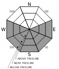
THIS AVALANCHE FORECAST EXPIRED ON March 18, 2019 @ 6:41 am
Avalanche Forecast published on March 17, 2019 @ 6:41 am
Issued by Brandon Schwartz - Tahoe National Forest

LOW avalanche danger early this morning will give way to MODERATE avalanche danger at all elevations today as a loose wet avalanche problem develops in response to rapid daytime warming.

2. Moderate

?

Above Treeline
Heightened avalanche conditions on specific terrain features. Evaluate snow and terrain carefully; identify features of concern.

2. Moderate

?

Near Treeline
Heightened avalanche conditions on specific terrain features. Evaluate snow and terrain carefully; identify features of concern.

2. Moderate

?

Below Treeline
Heightened avalanche conditions on specific terrain features. Evaluate snow and terrain carefully; identify features of concern.
    Heightened avalanche conditions on specific terrain features. Evaluate snow and terrain carefully; identify features of concern.
Avalanche Problem 1: Loose Wet
  • Type ?
  • Aspect/Elevation ?
  • Likelihood ?
    Certain
    Very Likely
    Likely
    Possible
    Unlikely
  • Size ?
    Historic
    Very Large
    Large
    Small

Above freezing air temperatures last night at the mid and upper elevations will give a head start on the development of a loose wet avalanche problem today. Rapid warming conditions are expected by mid morning. Once the surface crust has melted away, loose wet avalanches are possible. The vast majority of loose wet instability is expected on E-SE-S-SW-W aspects at all elevations. This avalanche problem may spread onto NW-N-NE aspects in isolated areas. Avalanche size is expected mostly at D1 with up to size D2 possible.

The transition from stable to unstable surface wet snow may occur in less than 1 hour today so timing is everything. Avoid late starts for travel in sun exposed avalanche terrain. Pay attention to snow surface melt. Once the surface crust is gone, it's avalanche time. Maintain awareness for the presence of other parties either above or below you in avalanche terrain.

recent observations

* Loose wet avalanches size D1 to D1.5 have been reported from around the forecast area on steep sun exposed slopes.

* Transitional snow surface conditions exist on E-SE-S-SW-W aspects with a thin layer of wet snow over dry snow in most areas, especially above 7,500'. In most locations, this is not a proper corn set up just yet.

* NW-N-NE aspects hold a mix of wind affected surfaces, unconsolidated snow yet to be affected by melt, and breakable crust depending on elevation and exposure to sun and past wind events.

* The existing snowpack is generally well consolidated and lacks widespread problematic weak layers. Snowpit test results indicating issues with problematic wind slabs are very isolated are this time.

Weather and CURRENT CONDITIONS
weather summary

High pressure will remain in place over the forecast area through Monday. Air temperature inversion conditions set up last night with above freezing overnight air temperatures for many locations at the mid slope and upper elevations. The coldest air is down on the mountain valley floors this morning. Maximum daytime air temperatures are expected to reach well into the 40s today for areas above 7,000'. Winds are forecast to remain light in speed. Similar conditions are expected for Monday. The next storm system is forecast to arrive Tuesday night.

CONDITIONS ALONG THE SIERRA CREST BETWEEN 8200 FT. AND 9200 FT. IN THE LAST 24 HOURS
6am temperature: 30 to 37 deg. F.
Max. temperature: 37 to 49 deg. F.
Average ridgetop wind direction: E
Average ridgetop wind speed: 10 mph
Maximum ridgetop wind gust: 24 mph
New snowfall: 0 inches
Total snow depth: 108 to 160 inches
Two-Day Mountain Weather Forecast Produced in partnership with the Reno NWS
For 7000 ft. to 8000 ft.
Sunday Sunday Night Monday
Weather: Sunny then becoming partly cloudy. Snow levels below 7000 feet. Chance of precipitation is 0%. Partly cloudy. Snow levels 7000 feet. Chance of precipitation is 0%. Sunny. Snow levels below 7000 feet increasing to 7000 feet in the afternoon. Chance of precipitation is 0%.
Temperatures: 46 to 51 deg. F. 21 to 29 deg. F. 46 to 51 deg. F.
Mid Slope Winds: Light winds. Light winds. Light winds.
Expected snowfall: No accumulation. | SWE = none. No accumulation. | SWE = none. No accumulation. | SWE = none.
For 8000 ft. to 9000 ft.
Sunday Sunday Night Monday
Weather: Sunny then becoming partly cloudy. Snow levels below 7000 feet. Chance of precipitation is 0%. Partly cloudy. Snow levels 7000 feet. Chance of precipitation is 0%. Partly cloudy then becoming sunny. Snow levels below 7000 feet increasing to 7000 feet in the afternoon. Chance of precipitation is 0%.
Temperatures: 41 to 47 deg. F. 20 to 26 deg. F. 40 to 46 deg. F.
Ridge Top Winds: Light winds. Light winds. Light winds.
Expected snowfall: No accumulation. | SWE = none. No accumulation. | SWE = none. No accumulation. | SWE = none.
Disclaimer

This avalanche forecast is provided through a partnership between the Tahoe National Forest and the Sierra Avalanche Center. This forecast covers the Central Sierra Nevada Mountains between Yuba Pass on the north and Ebbetts Pass on the south. Click here for a map of the forecast area. This forecast applies only to backcountry areas outside established ski area boundaries. This forecast describes general avalanche conditions and local variations always occur. This forecast expires 24 hours after the posted time unless otherwise noted. The information in this forecast is provided by the USDA Forest Service who is solely responsible for its content.

For a recorded version of the avalanche forecast call (530) 587-3558 x258