THIS AVALANCHE FORECAST EXPIRED ON March 19, 2019 @ 6:47 am
Avalanche Forecast published on March 18, 2019 @ 6:47 am
Issued by Brandon Schwartz - Tahoe National Forest

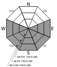
LOW avalanche danger early this morning will give way to MODERATE avalanche danger at all elevations today as a loose wet avalanche problem develops in response to rapid daytime warming.

2. Moderate

?

Above Treeline
Heightened avalanche conditions on specific terrain features. Evaluate snow and terrain carefully; identify features of concern.

2. Moderate

?

Near Treeline
Heightened avalanche conditions on specific terrain features. Evaluate snow and terrain carefully; identify features of concern.

2. Moderate

?

Below Treeline
Heightened avalanche conditions on specific terrain features. Evaluate snow and terrain carefully; identify features of concern.
    Heightened avalanche conditions on specific terrain features. Evaluate snow and terrain carefully; identify features of concern.
Avalanche Problem 1: Loose Wet
  • Type ?
  • Aspect/Elevation ?
  • Likelihood ?
    Certain
    Very Likely
    Likely
    Possible
    Unlikely
  • Size ?
    Historic
    Very Large
    Large
    Small

Another night of near to above freezing air temperatures at the mid and upper elevations will once again give a head start on the development of a loose wet avalanche problem today. Rapid warming conditions are again expected by mid morning. Once the surface crust has melted away, loose wet avalanches are possible. The vast majority of loose wet instability is expected on E-SE-S-SW-W aspects at all elevations. This avalanche problem may spread onto NW-N-NE aspects in isolated areas, mainly at low elevations. Avalanche size is expected mostly at D1 with up to size D2 possible.

For most areas, the transition from a frozen snow surface to a thin wet layer over dry snow will occur quickly today and is prone to loose wet avalanches. Pay close attention to the snow you are traveling on. If it is wet snow on top of dry snow with no crust in between, choose lower angle slopes and avoid steep terrain.

recent observations

* Daily reports of a few loose wet avalanches size D1 to D1.5 continue around the forecast area on steep sun exposed slopes.

* Transitional snow surface conditions still exist on many E-SE-S-SW-W aspects with a thin layer of wet snow over dry snow. In some areas, this is getting close to a corn setup. In most locations, it is not there just yet.

* NW-N-NE aspects hold a mix of wind affected surfaces, unconsolidated snow yet to be affected by melt, and breakable crust depending on elevation and exposure to sun and past wind events.

* The deeper existing snowpack is generally well consolidated and lacks widespread problematic weak layers.

Weather and CURRENT CONDITIONS
weather summary

High pressure over the forecast area will allow for another day of sunny skies, light winds, and above freezing air temperatures. Air temperature inversion conditions once again have near to above freezing air temperatures at mid slope and on the peaks this morning while the coldest air is on the mountain valley floors. Tuesday is forecast to have increasing mid to high level cloud cover and increasing S to SE winds ahead of the next storm system expected to arrive Tuesday night. This precipitation event is forecast to continue into Thursday. For more info on this upcoming storm, check with NWS Reno.

CONDITIONS ALONG THE SIERRA CREST BETWEEN 8200 FT. AND 9200 FT. IN THE LAST 24 HOURS
6am temperature: 32 to 35 deg. F.
Max. temperature: 38 to 51 deg. F.
Average ridgetop wind direction: SW
Average ridgetop wind speed: 10 mph
Maximum ridgetop wind gust: 27 mph
New snowfall: 0 inches
Total snow depth: 115 to 158 inches
Two-Day Mountain Weather Forecast Produced in partnership with the Reno NWS
For 7000 ft. to 8000 ft.
Monday Monday Night Tuesday
Weather: Sunny. Snow levels below 7000 feet increasing to 7000 feet in the afternoon. Chance of precipitation is 0%. Partly cloudy. Snow levels 7500 feet. Chance of precipitation is 0%. Mostly cloudy. Snow levels below 7000 feet increasing to 7500 feet in the afternoon. Chance of precipitation is 10%.
Temperatures: 45 to 51 deg. F. 24 to 29 deg. F. 47 to 52 deg. F.
Mid Slope Winds: Light winds. Light winds. Southeast around 10 mph.
Expected snowfall: No accumulation. | SWE = none. No accumulation. | SWE = none. No accumulation. | SWE = none.
For 8000 ft. to 9000 ft.
Monday Monday Night Tuesday
Weather: Sunny. Snow levels below 7000 feet increasing to 7000 feet in the afternoon. Chance of precipitation is 0%. Partly cloudy. Snow levels 7500 feet. Chance of precipitation is 0%. Mostly cloudy. Snow levels below 7000 feet increasing to 7500 feet in the afternoon. Chance of precipitation is 10%.
Temperatures: 39 to 45 deg. F. 22 to 27 deg. F. 41 to 47 deg. F.
Ridge Top Winds: South to southeast up to 10 mph. South around 10 mph becoming southeast around 15 mph with gusts to 25 mph after midnight. East to southeast around 15 mph with gusts to 30 mph.
Expected snowfall: No accumulation. | SWE = none. No accumulation. | SWE = none. No accumulation. | SWE = none.
Disclaimer

This avalanche forecast is provided through a partnership between the Tahoe National Forest and the Sierra Avalanche Center. This forecast covers the Central Sierra Nevada Mountains between Yuba Pass on the north and Ebbetts Pass on the south. Click here for a map of the forecast area. This forecast applies only to backcountry areas outside established ski area boundaries. This forecast describes general avalanche conditions and local variations always occur. This forecast expires 24 hours after the posted time unless otherwise noted. The information in this forecast is provided by the USDA Forest Service who is solely responsible for its content.

For a recorded version of the avalanche forecast call (530) 587-3558 x258