THIS AVALANCHE FORECAST EXPIRED ON March 20, 2019 @ 6:57 am
Avalanche Forecast published on March 19, 2019 @ 6:57 am
Issued by Steve Reynaud - Tahoe National Forest

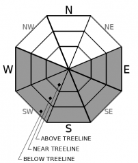
LOW avalanche danger this morning will transition to MODERATE avalanche danger as daytime warming occurs.  A loose wet avalanche problem will be possible at all elevations today. 

2. Moderate

?

Above Treeline
Heightened avalanche conditions on specific terrain features. Evaluate snow and terrain carefully; identify features of concern.

2. Moderate

?

Near Treeline
Heightened avalanche conditions on specific terrain features. Evaluate snow and terrain carefully; identify features of concern.

2. Moderate

?

Below Treeline
Heightened avalanche conditions on specific terrain features. Evaluate snow and terrain carefully; identify features of concern.
    Heightened avalanche conditions on specific terrain features. Evaluate snow and terrain carefully; identify features of concern.
Avalanche Problem 1: Loose Wet
  • Type ?
  • Aspect/Elevation ?
  • Likelihood ?
    Certain
    Very Likely
    Likely
    Possible
    Unlikely
  • Size ?
    Historic
    Very Large
    Large
    Small

A loose wet avalanche problem will develop today as daytime warming occurs.  Most of this loose wet activity is expected on E-SE-S-SW-W aspects but could also develop on NW-N-NE aspects.  Increasing cloud cover along with moderate E winds could delay snow surface warming during the morning hours.  With some overnight cloud cover and above freezing air temperatures, many areas may have received little to no snow surface refreeze.  Any light rain that falls this afternoon would further soften and weaken the snow surface. 

Wet surface snow on top of unsupportable soft snow may mean that your area didn't refreeze last night or sufficient warming has occurred for loose wet avalanche activity to become possible.  Roller balls and pinwheels will be indicators that the snow surface has lost strength and that larger loose wet avalanches could occur. 

recent observations

*  Continued reports come in with loose wet avalanches from around the forecast area.  Yesterday, a skier triggered size D2 loose wet avalanche was reported from Slide Mountain (Mt. Rose area) that ran 1200' with several feet of debris in the runout zone.

*  Transitional spring type snow exists on many E-SE-S-SW-W aspects and elevations.  Melt freeze crusts in these areas range from 1 to 4'' in thickness with cold snow existing below these crusts in many areas.  Corn snow has not fully transitioned at this point.

*  NW-N-NE aspects hold a mixed bag of snow surface conditions depending on elevation from cold unconsolidated snow, wind scoured, breakable crusts, and wet snow.  These aspects at higher elevations have not been affected by snow surface melt at this point.


Weather and CURRENT CONDITIONS
weather summary

Above average temperatures forecasted for today with increasing clouds and light to moderate E winds.  Light rain is possible this afternoon with snow levels starting around 8000'.  Light snow should start overnight and go into Wednesday and Thursday with a slow cooling trend.  Most snow should fall above 7000' for tonight through Wednesday and favor the Sierra Crest with 4 to 8'' of snow possible.  Unsettled weather continues through the week.


CONDITIONS ALONG THE SIERRA CREST BETWEEN 8200 FT. AND 9200 FT. IN THE LAST 24 HOURS
6am temperature: 29 to 37 deg. F.
Max. temperature: 40 to 48 deg. F.
Average ridgetop wind direction: S shifting to E
Average ridgetop wind speed: 10 to 20 mph
Maximum ridgetop wind gust: 37 mph
New snowfall: 0 inches
Total snow depth: 113 to 156 inches
Two-Day Mountain Weather Forecast Produced in partnership with the Reno NWS
For 7000 ft. to 8000 ft.
Tuesday Tuesday Night Wednesday
Weather: Mostly cloudy. Slight chance of rain and snow in the afternoon. Snow levels below 7000 feet increasing to 7500 feet in the afternoon. Chance of precipitation is 15%. Cloudy. Snow and rain likely. Snow levels 7500 feet decreasing to below 7000 feet after midnight. Chance of precipitation is 75%. Cloudy. Snow likely in the morning, then snow showers likely and slight chance of thunderstorms in the afternoon. Snow levels below 7000 feet. Chance of precipitation is 75%.
Temperatures: 46 to 51. deg. F. 29 to 34. deg. F. 34 to 39. deg. F.
Mid Slope Winds: Light winds. Light winds. Gusts up to 30 mph after midnight. Light winds.
Expected snowfall: No accumulation. | SWE = trace amounts. 70% probability of 1 to 3 inches. 30% probability of 3 to 5 inches. | SWE = 0.15-0.25 inch. 70% probability of 2 to 4 inches. 30% probability up to 2 inches. | SWE = 0.20-0.30 inch.
For 8000 ft. to 9000 ft.
Tuesday Tuesday Night Wednesday
Weather: Mostly cloudy. Slight chance of snow in the afternoon. Snow levels below 8000 feet. Chance of precipitation is 15%. Cloudy. Chance of snow in the evening, then snow after midnight. Snow levels below 8000 feet. Chance of precipitation is 75%. Cloudy. Snow likely in the morning, then snow showers and slight chance of thunderstorms in the afternoon. Snow levels below 7000 feet. Chance of precipitation is 75%.
Temperatures: 40 to 46. deg. F. 25 to 30. deg. F. 29 to 35. deg. F.
Ridge Top Winds: East around 15 mph with gusts to 25 mph. Southeast 15 to 20 mph. Gusts up to 30 mph increasing to 45 mph after midnight. South 15 to 20 mph with gusts to 45 mph.
Expected snowfall: No accumulation. | SWE = trace amounts. 70% probability of 1 to 4 inches. 30% probability of 4 to 6 inches. | SWE = 0.15-0.25 inch. 70% probability of 2 to 5 inches. 30% probability up to 2 inches. | SWE = 0.20-0.30 inch.
Disclaimer

This avalanche forecast is provided through a partnership between the Tahoe National Forest and the Sierra Avalanche Center. This forecast covers the Central Sierra Nevada Mountains between Yuba Pass on the north and Ebbetts Pass on the south. Click here for a map of the forecast area. This forecast applies only to backcountry areas outside established ski area boundaries. This forecast describes general avalanche conditions and local variations always occur. This forecast expires 24 hours after the posted time unless otherwise noted. The information in this forecast is provided by the USDA Forest Service who is solely responsible for its content.

For a recorded version of the avalanche forecast call (530) 587-3558 x258