


For 7000 ft. to 8000 ft.
| Wednesday | Wednesday Night | Thursday | |
|---|---|---|---|
| Weather: | Mostly cloudy. A chance of snow showers in the morning, then widespread snow showers and slight chance of thunderstorms in the afternoon. Snow levels below 7000 feet. Chance of precipitation is 75%. | Cloudy. Widespread snow showers and slight chance of thunderstorms in the evening, then chance of snow showers after midnight. Snow levels below 7000 feet. Chance of precipitation is 65%. | Mostly cloudy. Chance of snow showers. Snow levels below 7000 feet. Chance of precipitation is 45%. |
| Temperatures: | 35 to 40. deg. F. | 22 to 27. deg. F. | 34 to 39. deg. F. |
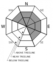
| Mid Slope Winds: | South 15 to 20 mph with gusts to 35 mph. | West to northwest winds around 10 mph. | West to northwest winds around 10 mph. |
| Expected snowfall: | 70% probability up to 1 inch. 30% probability 1 to 2 inches. | SWE = up to 0.15 inch. | up to 1 inch. | SWE = less than 0.10 inch. | up to 1 inch. | SWE = less than 0.10 inch. |
For 8000 ft. to 9000 ft.
| Wednesday | Wednesday Night | Thursday | |
|---|---|---|---|
| Weather: | Mostly cloudy. A chance of snow showers in the morning, then widespread snow showers and slight chance of thunderstorms in the afternoon. Snow levels below 7000 feet. Chance of precipitation is 75%. | Cloudy. Widespread snow showers and slight chance of thunderstorms in the evening, then chance of snow showers after midnight. Snow levels below 7000 feet. Chance of precipitation is 65%. | Mostly cloudy. Chance of snow showers. Snow levels below 7000 feet. Chance of precipitation is 50%. |
| Temperatures: | 30 to 36. deg. F. | 18 to 24. deg. F. | 29 to 35. deg. F. |
| Ridge Top Winds: | South 20 to 40 mph with gusts to 55 mph in the morning decreasing to 15 to 25 mph with gusts to 40 mph in the afternoon. | West to northwest 10 to 20 mph with gusts to 30 mph. | West to northwest around 15 mph with gusts to 25 mph. |
| Expected snowfall: | 70% probability up to 1 inch. 30% probability 1 to 3 inches. | SWE = up to 0.15 inch. | up to 2 inches. | SWE = less than 0.10 inch. | up to 1 inch. | SWE = less than 0.10 inch. |


