THIS AVALANCHE FORECAST EXPIRED ON March 29, 2019 @ 7:15 am
Avalanche Forecast published on March 28, 2019 @ 7:15 am
Issued by Andy Anderson - Tahoe National Forest - Sierra Avalanche Center

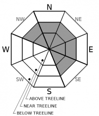
CONSIDERABLE avalanche danger exists in near and above treeline terrain with MODERATE danger in below treeline areas due to likely wind slab and possible storm slab problems. Human-triggered avalanche activity is likely today.

3. Considerable

?

Above Treeline
Dangerous avalanche conditions. Careful snowpack evaluation, cautious route-finding and conservative decision-making essential.

3. Considerable

?

Near Treeline
Dangerous avalanche conditions. Careful snowpack evaluation, cautious route-finding and conservative decision-making essential.

2. Moderate

?

Below Treeline
Heightened avalanche conditions on specific terrain features. Evaluate snow and terrain carefully; identify features of concern.
    Dangerous avalanche conditions. Careful snowpack evaluation, cautious route-finding and conservative decision-making essential.
Avalanche Problem 1: Wind Slab
  • Type ?
  • Aspect/Elevation ?
  • Likelihood ?
    Certain
    Very Likely
    Likely
    Possible
    Unlikely
  • Size ?
    Historic
    Very Large
    Large
    Small

Strong SW winds and significant amounts of new snow allowed yesterday's nascent wind slabs to grow larger and more widespread during the night. These slabs of wind drifted snow will continue to increase in size and extent as winds continue to transport snow onto leeward slopes today. Human triggered wind slabs are likely and some natural ones may remain possible in areas with ongoing wind-loading. Wind slab avalanches could entrain enough snow to bury or injure a person and could be several feet deep.

Make a plan that builds conservative safety margins around wind-loaded terrain. Look for signs of wind-loading like cornices above a slope, blowing snow, drifted snow, and other wind created features to maintain awareness of the terrain and conditions. Avoiding these areas in favor of more sheltered terrain and lower angle slopes should help reduce exposure to avalanche hazards and help find more consistent soft snow for recreation. 

Avalanche Problem 2: Storm Slab
  • Type ?
  • Aspect/Elevation ?
  • Likelihood ?
    Certain
    Very Likely
    Likely
    Possible
    Unlikely
  • Size ?
    Historic
    Very Large
    Large
    Small

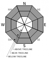
Changing conditions during the storm left softer lighter snow under more dense snow. This upside-down layering may allow human-triggered storm slab avalanches to be possible today especially on steep open slopes with convex rollovers. Storm slab size should remain limited in most places due to the smaller paths that exist in more sheltered terrain. However, some of them may still involve enough snow to bury or injure a person particularly in areas with terrain traps

Identify where storm slabs may exist by looking for clues like recent avalanche activity, cracking around your equipment, or feeling a density change in the storm snow with quick hand pits or while probing. Moving to less steep terrain will provide a great way to manage the potential storm slabs and still take advantage of the soft snow in sheltered areas. 

Forecast discussion

As long as skies remain cloudy today warming instabilities should remain unlikely. If the sun does make an appearance, some loose wet snow instabilities could form and warming could exacerbate existing avalanche problems.

recent observations

* Yesterday observations from Elephants Hump, Powderhouse Peak, Ward Canyon, Mt. Judah, and Incline Lake Peak all found stormy conditions with strong winds and some new snow accumulations during the day. The Carson Pass and Luther Pass areas had the deepest new snow (up to 6 inches).

* Some shooting cracks and small wind slab failures occurred in response to ski cuts on small test slopes on Powderhouse Peak. 

* In the areas north of Emerald Bay, less new snow had accumulated and signs of wind slab instability were harder to find. 

* In all the areas, a layer of softer snow existed under a layer of more dense snow within the new snow. Not enough new snow existed for a storm slab problem yet but the potential storm snow weakness was there.

Weather and CURRENT CONDITIONS
weather summary

Snowfall intensity picked up late yesterday and continued through about midnight. Snow showers tapered off after midnight. New snow amounts totaled 9 to 15 inches with the areas south of Hwy 50 receiving the most snow. The SW winds followed a similar pattern but should still remain strong enough to transport snow today. Snow showers should continue to diminish today and only 1 to 2 inches of new snow is expected during the day. Some of this may fall during convective snow showers that could produce isolated thunder and lightning this afternoon. By tonight skies should start to clear and winds should conintue to decrease as the storm departs the area. Expect sunnier skies and warmer temperatures tomorrow and through the weekend. 

CONDITIONS ALONG THE SIERRA CREST BETWEEN 8200 FT. AND 9200 FT. IN THE LAST 24 HOURS
6am temperature: 18 to 23 deg. F.
Max. temperature: 29 to 33 deg. F.
Average ridgetop wind direction: SW
Average ridgetop wind speed: 45 to 50 mph
Maximum ridgetop wind gust: 102 mph
New snowfall: 9 to 15 inches
Total snow depth: 112 to 167 inches
Two-Day Mountain Weather Forecast Produced in partnership with the Reno NWS
For 7000 ft. to 8000 ft.
Thursday Thursday Night Friday
Weather: Mostly cloudy. Chance of snow showers through the day. An isolated thunderstorm is possible in the afternoon. Snow levels below 7000 feet. Chance of precipitation is 55%. Mostly cloudy. Chance of snow showers. Snow levels below 7000 feet. Chance of precipitation is 35%. Partly cloudy. Snow levels below 7000 feet. Chance of precipitation is 5%.
Temperatures: 33 to 39 deg. F. 17 to 22 deg. F. 37 to 43 deg. F.
Mid Slope Winds: Southwest 15 to 25 mph with gusts to 35 mph. Southwest 15 to 20 mph. Gusts up to 30 mph. West less than 10 mph.
Expected snowfall: 60% probability 1-2 inches. 40% probability no accumulation. | SWE = less than 0.10 inch. 70% probability no accumulation. 30% probability 1-2 inches | SWE = less than 0.10 inch. No accumulation. | SWE = none.
For 8000 ft. to 9000 ft.
Thursday Thursday Night Friday
Weather: Mostly cloudy. Chance of snow showers through the day. An isolated thunderstorm is possible in the afternoon. Snow levels below 7000 feet. Chance of precipitation is 55%. Mostly cloudy then becoming partly cloudy. Chance of snow showers. Snow levels below 7000 feet. Chance of precipitation is 40%. Partly cloudy. Snow levels below 7000 feet. Chance of precipitation is 5%.
Temperatures: 28 to 34 deg. F. 14 to 19 deg. F. 30 to 36 deg. F.
Ridge Top Winds: Southwest 20 to 35 mph with gusts up to 60 mph. Southwest 15 to 30 mph. Gusts up to 50 mph decreasing to 40 mph after midnight. West 10 to 15 mph.
Expected snowfall: 60% probability 1-2 inches. 40% probability no accumulation. | SWE = less than 0.10 inch. 70% probability no accumulation. 30% probability up to 2 inches. | SWE = less than 0.10 inch. No accumulation. | SWE = none.
Disclaimer

This avalanche forecast is provided through a partnership between the Tahoe National Forest and the Sierra Avalanche Center. This forecast covers the Central Sierra Nevada Mountains between Yuba Pass on the north and Ebbetts Pass on the south. Click here for a map of the forecast area. This forecast applies only to backcountry areas outside established ski area boundaries. This forecast describes general avalanche conditions and local variations always occur. This forecast expires 24 hours after the posted time unless otherwise noted. The information in this forecast is provided by the USDA Forest Service who is solely responsible for its content.

For a recorded version of the avalanche forecast call (530) 587-3558 x258