THIS AVALANCHE FORECAST EXPIRED ON March 30, 2019 @ 6:59 am
Avalanche Forecast published on March 29, 2019 @ 6:59 am
Issued by Andy Anderson - Tahoe National Forest - Sierra Avalanche Center

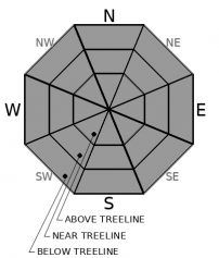
MODERATE avalanche danger will exist at all elevations today. Enough daytime warming should occur for loose wet avalanche problems to form and some lingering wind slab problems still exist. Human triggered avalanches remain possible today.

2. Moderate

?

Above Treeline
Heightened avalanche conditions on specific terrain features. Evaluate snow and terrain carefully; identify features of concern.

2. Moderate

?

Near Treeline
Heightened avalanche conditions on specific terrain features. Evaluate snow and terrain carefully; identify features of concern.

2. Moderate

?

Below Treeline
Heightened avalanche conditions on specific terrain features. Evaluate snow and terrain carefully; identify features of concern.
    Heightened avalanche conditions on specific terrain features. Evaluate snow and terrain carefully; identify features of concern.
Avalanche Problem 1: Loose Wet
  • Type ?
  • Aspect/Elevation ?
  • Likelihood ?
    Certain
    Very Likely
    Likely
    Possible
    Unlikely
  • Size ?
    Historic
    Very Large
    Large
    Small

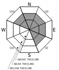
As soon as the sun hits the slopes today the new snow will start to warm. This daytime warming will allow loose wet avalanches involving most of the new snow to become possible. In areas where the loose wet avalanches can run long distances down steep sun-exposed slopes, they could entrain enough snow to have serious consequences for backcountry travelers. Sun-exposed E-SE-S-SW-W aspects will experience the most warming and be most susceptible to loose wet avalanche activity, but some wet snow may form on sun-exposed northerly aspects as well.  

Once the snow starts to feel wet and heavy and/or small pinwheels or roller balls start to occur, it is time to move to a colder more shaded aspect. Moving to these colder aspects will provide better snow and less hazardous conditions. 

Avalanche Problem 2: Wind Slab
  • Type ?
  • Aspect/Elevation ?
  • Likelihood ?
    Certain
    Very Likely
    Likely
    Possible
    Unlikely
  • Size ?
    Historic
    Very Large
    Large
    Small

Slabs of wind drifted snow still linger on leeward aspects in near and above treeline terrain. Human-triggered wind slab avalanches still remain possible today. These could involve enough snow to bury, injure, or kill a person in some areas. The warming that occurs today may make some of the wind slabs that exist on sun-exposed slopes easier to trigger.

Cornices above a slope, drifted snow, and other wind created features can help identify where wind slabs may exist. Evaluate any areas where wind slabs may lurk carefully. Recreating in sheltered and shaded terrain should reduce exposure to avalanche hazards and provide colder more consistent soft snow. 

recent observations

* A few small wind slab avalanches about 1 ft deep were reported on Mt. Lola yesterday. One of them was snowmobile triggered and the reporting party could see tracks going in and out of the avalanche. Two others were naturally triggered possibly by cornice failures.

* Snowmobile cuts on test slopes in the Mt. Lola area produced shooting cracks and smaller wind slab failures.

* Ski cuts on small wind loaded test slopes on Rubicon, Jakes Peak, and Talking Mountain also produced some cracking. On Rubicon and Jakes the cracking propagated a few feet away from the skiers and on Talking the cracking remained limited to just below the skier. Some continued wind transport was reported on the Echo Summit ridgelines. 

* Observations from sheltered areas on Brockway Summit, Rubicon, Jakes, and Talking Mountain did not find lingering signs of storm slab instability.

* Observers did report warming snow on sun-exposed aspects but loose wet instabilities remained small and isolated. One small loose wet sluff occurred on a SE facing slope on Jakes Peak and one on an E facing slope on Hidden Peak. In other areas, the surface snow just got wet and heavy without enough warming for loose wet instabilities to form. 

Weather and CURRENT CONDITIONS
weather summary

Convective snow showers continued into the night allowing some areas to pick up close to 4 inches of new snow while other areas only gained about an inch. These snow showers cleared out after midnight ushering in calmer drier weather. The forecast calls for partly cloudy to mostly sunny skies today with warmer temperatures. This trend of clear, dry, and warmer weather will continue through the weekend with temperatures climbing some each day.

CONDITIONS ALONG THE SIERRA CREST BETWEEN 8200 FT. AND 9200 FT. IN THE LAST 24 HOURS
6am temperature: 19 to 24 deg. F.
Max. temperature: 25 to 32 deg. F.
Average ridgetop wind direction: SW
Average ridgetop wind speed: 30 to 40 mph
Maximum ridgetop wind gust: 73 mph
New snowfall: 1 to 4 inches
Total snow depth: 115 to 167 inches
Two-Day Mountain Weather Forecast Produced in partnership with the Reno NWS
For 7000 ft. to 8000 ft.
Friday Friday Night Saturday
Weather: Partly cloudy to mostly sunny. Snow levels below 7000 feet. Chance of precipitation is 5%. Partly cloudy then becoming clear. Snow levels below 7000 feet. Chance of precipitation is 5%. Sunny. Snow levels below 7000 feet. Chance of precipitation is 0%.
Temperatures: 36 to 42 deg. F. 16 to 21 deg. F. 38 to 43 deg. F.
Mid Slope Winds: Light winds. Light winds. East 5 to 10 mph.
Expected snowfall: No accumulation. | SWE = none. No accumulation. | SWE = none. No accumulation. | SWE = none.
For 8000 ft. to 9000 ft.
Friday Friday Night Saturday
Weather: Partly cloudy to mostly sunny. Snow levels below 7000 feet. Chance of precipitation is 5%. Partly cloudy then becoming clear. Snow levels below 7000 feet. Chance of precipitation is 5%. Sunny. Snow levels below 7000 feet. Chance of precipitation is 0%.
Temperatures: 29 to 37 deg. F. 14 to 19 deg. F. 33 to 39 deg. F.
Ridge Top Winds: West 5 to 10 mph. West around 10 mph shifting to the east after midnight. East around 10 mph.
Expected snowfall: No accumulation. | SWE = none. No accumulation. | SWE = none. No accumulation. | SWE = none.
Disclaimer

This avalanche forecast is provided through a partnership between the Tahoe National Forest and the Sierra Avalanche Center. This forecast covers the Central Sierra Nevada Mountains between Yuba Pass on the north and Ebbetts Pass on the south. Click here for a map of the forecast area. This forecast applies only to backcountry areas outside established ski area boundaries. This forecast describes general avalanche conditions and local variations always occur. This forecast expires 24 hours after the posted time unless otherwise noted. The information in this forecast is provided by the USDA Forest Service who is solely responsible for its content.

For a recorded version of the avalanche forecast call (530) 587-3558 x258