THIS AVALANCHE FORECAST EXPIRED ON November 29, 2019 @ 6:52 am
Avalanche Forecast published on November 27, 2019 @ 6:52 am
Issued by Brandon Schwartz - Tahoe National Forest

Welcome to winter. CONSIDERABLE avalanche danger exists in near treeline and above treeline areas due to wind slabs. MODERATE avalanche danger exists below treeline due to the possibility of storm slabs. Snowcover is thin and there are lots of rocks to hit. Travel with care. This is a 48 hour forecast to cover Wednesday and Thanksgiving day. The next update will occur on Friday by 7 am.

3. Considerable

?

Above Treeline
Dangerous avalanche conditions. Careful snowpack evaluation, cautious route-finding and conservative decision-making essential.

3. Considerable

?

Near Treeline
Dangerous avalanche conditions. Careful snowpack evaluation, cautious route-finding and conservative decision-making essential.

2. Moderate

?

Below Treeline
Heightened avalanche conditions on specific terrain features. Evaluate snow and terrain carefully; identify features of concern.
    Dangerous avalanche conditions. Careful snowpack evaluation, cautious route-finding and conservative decision-making essential.
Avalanche Problem 1: Wind Slab
  • Type ?
  • Aspect/Elevation ?
  • Likelihood ?
    Certain
    Very Likely
    Likely
    Possible
    Unlikely
  • Size ?
    Historic
    Very Large
    Large
    Small

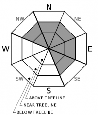
Wind slabs are likely today and Thursday, created by the moderate to gale force SW winds that have drifted snow along the ridgetops and other wind exposed areas. The vast majority of winds slabs will exist in near treeline and above treeline terrain on NW-N-NE-E-SE aspects. Expected avalanche size is up to D2. Use clues such as blowing snow, pillows of drifted snow, signs of cornice formation, and areas of deeper, denser snow to identify where wind slabs exist and route find around them. 

Avalanche Problem 2: Storm Slab
  • Type ?
  • Aspect/Elevation ?
  • Likelihood ?
    Certain
    Very Likely
    Likely
    Possible
    Unlikely
  • Size ?
    Historic
    Very Large
    Large
    Small

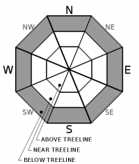
New snow that accumulates today and Thursday will do so under more variable conditions. This will allow for a greater chance of storm slab formation than just new snow on bare ground. The possibility of storm slab avalanches will become more widespread in wind protected areas below treeline on all aspects today and tomorrow. There is also a small chance that locations on the east side of the forecast area where new snow was deposited on top of a thin layer of moderately faceted (sugary) snow leftover from the Nov 19-20 snowfall may be problematic. Signs of snow surface cracking or collapsing in wind protected areas below treeline indicate the presence of unstable storm slabs in the immediate area. Avalanche size is expected at D1 with the isolated possibility of a size D2.

recent observations

Prior to this storm, most locations within the forecast area were bare ground. Some areas of patchy, moderately faceted (sugary) snow 1 to 3 inches deep lingered along the eastern edge of the forecast area on NW-N-NE aspects. Most of this snow was in wind protected areas at and below treeline.

Weather and CURRENT CONDITIONS
weather summary

The cold front associated with the current storm system is exiting the region, leaving plenty of cold air behind it over the forecast area. New snow amounts are in the 10 to 20 inch range. Snowfall will continue today and tomorrow with an additional 5 to 10 inches around Lake Tahoe and a foot or more of accumulation expected along the Sierra Crest by late tomorrow. High intensity snow showers may also occur along the east side of Lake Tahoe due to lake effect enhancement. SW ridgetop winds have decreased from gale force to moderate speed this morning. Winds are forecast to further decrease this afternoon, becoming light in speed tomorrow. Air temperatures are expected to remain below average this week. The next storm system is forecast for the Sat-Mon timeframe with copious moisture and rising snow levels.

CONDITIONS ALONG THE SIERRA CREST BETWEEN 8200 FT. AND 9200 FT. IN THE LAST 24 HOURS
6am temperature: 11 to 17 deg. F.
Max. temperature: 17 to 21 deg. F.
Average ridgetop wind direction: SW
Average ridgetop wind speed: 55 mph
Maximum ridgetop wind gust: 116 mph
New snowfall: 10 to 20 inches
Total snow depth: 10 to 22 inches
Two-Day Mountain Weather Forecast Produced in partnership with the Reno NWS
For 7000 ft. to 8000 ft.
Wednesday Wednesday Night Thursday
Weather: Cloudy skies. Snow in the morning, then snow showers in the afternoon. Snow levels below 7,000'. Chance of precipitation is 90%. Cloudy skies. Snow showers likely. Snow levels below 7,000'. Chance of precipitation is 60%. Cloudy skies with a chance of snow showers. Snow levels below 7,000'. Chance of precipitation is 45%.
Temperatures: 20 to 25 deg. F. 10 to 15 deg. F. 18 to 23 deg. F.
Mid Slope Winds: Southwest 15 to 30 mph. Gusts to 50 mph decreasing to 40 mph in the afternoon. Southwest around 15 mph with gusts to 25 mph in the evening, becoming light. Light winds.
Expected snowfall: 80% probability of 4 to 10 inches, 20% probability of 2 to 4 inches | SWE = 0.25 to 0.5 inch 80% probability of 2 to 6 inches, 20% probability of 6 to 8 inches | SWE = up to 0.3 inch 80% probability of up to 2 inches, 20% probability of 2 to 4 inches | SWE = less than 0.1 inch
For 8000 ft. to 9000 ft.
Wednesday Wednesday Night Thursday
Weather: Cloudy skies. Snow in the morning, then snow showers in the afternoon. Snow levels below 7,000'. Chance of precipitation is 95%. Cloudy skies. Snow showers likely. Snow levels below 7,000'. Chance of precipitation is 65%. Cloudy skies with a chance of snow showers. Snow levels below 7,000'. Chance of precipitation is 45%.
Temperatures: 16 to 21 deg. F. 7 to 12 deg. F. 13 to 19 deg. F.
Ridge Top Winds: Southwest 30 to 40 mph with gusts to 70 mph, decreasing to 20 to 30 mph with gusts to 50 mph in the afternoon. Southwest 15 to 20 mph. Gusts up to 35 mph in the evening. Southeast around 15 mph in the morning, becoming light.
Expected snowfall: 80% probability of 4 to 10 inches, 20% probability of 10 to 12 inches | SWE = 0.25 to 0.5 inch 80% probability of 2 to 6 inches, 20% probability of 6 to 8 inches | SWE = 0.15 to 0.35 inch 80% probability of 1 to 3 inches, 20% probability of 3 to 5 inches | SWE = less than 0.1 inch
Disclaimer

This avalanche forecast is provided through a partnership between the Tahoe National Forest and the Sierra Avalanche Center. This forecast covers the Central Sierra Nevada Mountains between Yuba Pass on the north and Ebbetts Pass on the south. Click here for a map of the forecast area. This forecast applies only to backcountry areas outside established ski area boundaries. This forecast describes general avalanche conditions and local variations always occur. This forecast expires 24 hours after the posted time unless otherwise noted. The information in this forecast is provided by the USDA Forest Service who is solely responsible for its content.

For a recorded version of the avalanche forecast call (530) 587-3558 x258