THIS AVALANCHE FORECAST EXPIRED ON April 12, 2020 @ 7:27 am
Avalanche Forecast published on April 11, 2020 @ 7:27 am
Issued by Andy Anderson - Tahoe National Forest - Sierra Avalanche Center

Warm sunny weather today will cause sluffs of wet snow to become a problem at all elevations as the day warms up. In addition to these loose wet avalanches, lingering slabs of wind drifted snow may still exist in some near and above treeline areas as well as an unlikely but not impossible persistent slab problem in some isolated spot. Human triggered avalanches remain possible today. MODERATE avalanche danger continues at all elevations.

2. Moderate

?

Above Treeline
Heightened avalanche conditions on specific terrain features. Evaluate snow and terrain carefully; identify features of concern.

2. Moderate

?

Near Treeline
Heightened avalanche conditions on specific terrain features. Evaluate snow and terrain carefully; identify features of concern.

2. Moderate

?

Below Treeline
Heightened avalanche conditions on specific terrain features. Evaluate snow and terrain carefully; identify features of concern.
    Heightened avalanche conditions on specific terrain features. Evaluate snow and terrain carefully; identify features of concern.
Avalanche Problem 1: Loose Wet
  • Type ?
  • Aspect/Elevation ?
  • Likelihood ?
    Certain
    Very Likely
    Likely
    Possible
    Unlikely
  • Size ?
    Historic
    Very Large
    Large
    Small

Strong April sunshine and daytime warming will quickly melt through last night's weak refreeze. Enough wet snow will form for loose wet avalanches to occur on steep slopes. This loose wet problem will form first on sunny E-SE-S-SW-W aspects but wet snow may also form on the northerly aspects this afternoon. These loose wet avalanches would entrain enough snow to carry a person downslope. They may involve enough wet snow to bury a person especially on larger slopes or in areas where the loose wet avalanche flows into a terrain trap like a gully. Today's rapid warming will also weaken existing cornices and make it easier for them to fail. 

Getting out early while the snowpack remains supportable and returning before it gets too wet represents one way to manage wet snow instabilities. Avoiding steep slopes and using lower angle terrain is another. Regardless, once the snow starts to get wet and sticky or small roller balls and pinwheels start to occur it is time to move to a different place without wet snow or call it a day. 

Avalanche Problem 2: Wind Slab
  • Type ?
  • Aspect/Elevation ?
  • Likelihood ?
    Certain
    Very Likely
    Likely
    Possible
    Unlikely
  • Size ?
    Historic
    Very Large
    Large
    Small

Fragile slabs of wind drifted snow may still linger on some SE-S-SW-W-NW-N aspects due to wind loading by the recent ENE winds. Human triggered wind slab avalanches may remain possible in near and above treeline areas especially in the southern part of the forecast area where more snow fell on Thursday.

Cornices above a slope, wind drifted snow, scoured areas on a ridge, and other wind created surface textures can help identify where problematic wind slabs may still exist. Sun and rapid warming could make it easier to trigger these wind slabs.


Avalanche Problem 3: Persistent Slab
  • Type ?
  • Aspect/Elevation ?
  • Likelihood ?
    Certain
    Very Likely
    Likely
    Possible
    Unlikely
  • Size ?
    Historic
    Very Large
    Large
    Small

The last known persistent slab avalanche occurred on Wednesday. Data seems to indicate that this problem has become unlikely on a regional scale, but some snowpack tests still show weakness near a crust layer buried 1 to 3 ft below the surface. This problem seems to be lingering in higher elevation terrain. Since some uncertainty still lingers about this problem, persistent slabs still warrant consideration while traveling the backcountry. 

recent observations

Yesterday a small skier triggered wind slab avalanche occurred on a W facing slope on Red Lake Peak. 

Recent skier triggered loose wet avalanches were observed on Silver Peak. Ankle to shin-deep wet snow existed on sun-exposed slopes by 10 am yesterday. 

Snowpit tests on northerly aspects on Red Lake Peak indicated ongoing instability near the recently buried crust layer. On Silver Peak, snowpit tests did not indicate continued instability near the buried crusts. Breakable crusts existed on northerly aspects on Silver Peak.

Weather and CURRENT CONDITIONS
weather summary

A high-pressure ridge over the region will keep the weather sunny and warm today. Some cloud cover and increased winds could develop tonight ahead of a weak cold front expected to arrive over the area tomorrow. The forecast calls for cooler weather and a chance of light precipitation tomorrow.

CONDITIONS ALONG THE SIERRA CREST BETWEEN 8200 FT. AND 9200 FT. IN THE LAST 24 HOURS
6am temperature: 29 to 38 deg. F.
Max. temperature: 41 to 52 deg. F.
Average ridgetop wind direction: ENE
Average ridgetop wind speed: 5 to 15 mph with some areas near Carson Pass reporting 25 to 30 mph
Maximum ridgetop wind gust: 30 mph with one sensor reporting 52 mph
New snowfall: 0 inches
Total snow depth: 65 to 84 inches
Two-Day Mountain Weather Forecast Produced in partnership with the Reno NWS
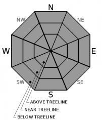
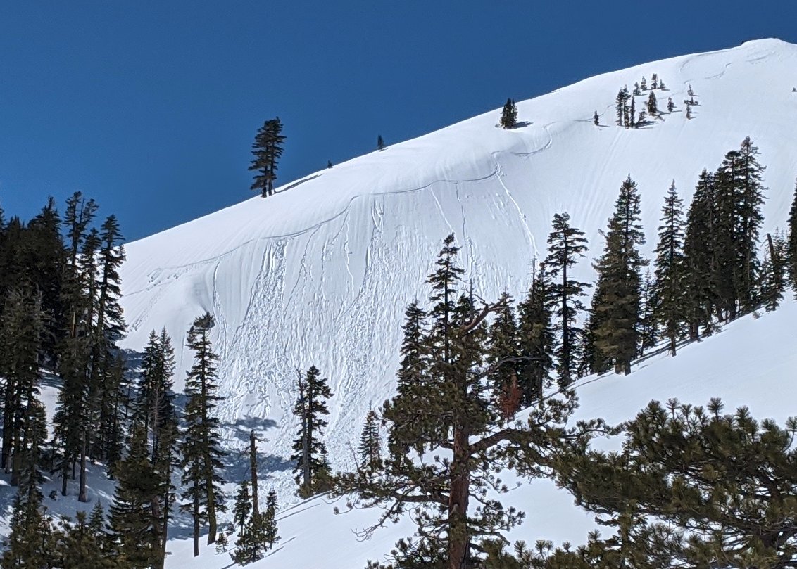
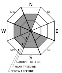
For 7000 ft. to 8000 ft.
Saturday Saturday Night Sunday
Weather: Sunny. Snow levels 8500 feet. Chance of precipitation is 5%. Partly cloudy then becoming mostly cloudy. Snow levels 9000 feet. Chance of precipitation is 5%. Mostly cloudy then becoming partly cloudy. Slight chance of showers in the afternoon. Snow levels below 7000 feet. Chance of precipitation is 15%.
Temperatures: 51 to 57. deg. F. 28 to 33. deg. F. 44 to 50. deg. F.
Mid Slope Winds: Light winds. Gusts up to 25 mph in the afternoon. Light winds. Light winds.
Expected snowfall: No accumulation. | SWE = none. No accumulation. | SWE = none. No accumulation. | SWE = trace amounts.
For 8000 ft. to 9000 ft.
Saturday Saturday Night Sunday
Weather: Sunny. Snow levels 8500 feet. Chance of precipitation is 5%. Partly cloudy then becoming mostly cloudy. Snow levels 9000 feet. Chance of precipitation is 5%. Mostly cloudy. Slight chance of snow showers in the afternoon. Snow levels 7000 feet. Chance of precipitation is 20%.
Temperatures: 45 to 51. deg. F. 25 to 30. deg. F. 38 to 44. deg. F.
Ridge Top Winds: Northwest around 15 mph with gusts to 25 mph. Northwest around 15 mph. Gusts up to 25 mph in the evening. Light winds becoming northeast around 15 mph in the afternoon.
Expected snowfall: No accumulation. | SWE = none. No accumulation. | SWE = none. No accumulation. | SWE = trace amounts.
Disclaimer

This avalanche forecast is provided through a partnership between the Tahoe National Forest and the Sierra Avalanche Center. This forecast covers the Central Sierra Nevada Mountains between Yuba Pass on the north and Ebbetts Pass on the south. Click here for a map of the forecast area. This forecast applies only to backcountry areas outside established ski area boundaries. This forecast describes general avalanche conditions and local variations always occur. This forecast expires 24 hours after the posted time unless otherwise noted. The information in this forecast is provided by the USDA Forest Service who is solely responsible for its content.

For a recorded version of the avalanche forecast call (530) 587-3558 x258