THIS AVALANCHE FORECAST EXPIRED ON April 15, 2020 @ 6:45 am
Avalanche Forecast published on April 14, 2020 @ 6:45 am
Issued by Brandon Schwartz - Tahoe National Forest

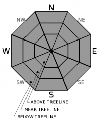
Loose wet avalanche problems will develop quickly today in wind protected areas. Wet slab avalanches also warrant consideration. LOW avalanche danger very early this morning will increase to MODERATE avalanche danger as the morning progresses.

2. Moderate

?

Above Treeline
Heightened avalanche conditions on specific terrain features. Evaluate snow and terrain carefully; identify features of concern.

2. Moderate

?

Near Treeline
Heightened avalanche conditions on specific terrain features. Evaluate snow and terrain carefully; identify features of concern.

2. Moderate

?

Below Treeline
Heightened avalanche conditions on specific terrain features. Evaluate snow and terrain carefully; identify features of concern.
    Heightened avalanche conditions on specific terrain features. Evaluate snow and terrain carefully; identify features of concern.
Avalanche Problem 1: Loose Wet
  • Type ?
  • Aspect/Elevation ?
  • Likelihood ?
    Certain
    Very Likely
    Likely
    Possible
    Unlikely
  • Size ?
    Historic
    Very Large
    Large
    Small

A strong but superficial snow surface refreeze is expected to have occurred last night with clear skies and below freezing air temperatures. Strong mid April sunshine will rapidly melt the firm snow surface as the morning progresses. Once the surface crust melts away, deep wet snow prone to loose wet avalanches will exist. Avalanche size up to D2 is expected.

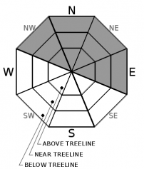
While NE winds will keep the snow surface frozen at and near ridgetops for much of the day, rapid melt will occur just off of the ridgetops and on the slopes below. Don't be fooled by firm frozen surfaces on ridgetops or other wind exposed areas. Anticipate rapid melt rates on the slopes below. Avoid steep terrain in areas where the surface crust is no longer supportable. E-SE-S aspects will melt the quickest, followed by SW-W-NW-N-NE aspects.

Avalanche Problem 2: Wet Slab
  • Type ?
  • Aspect/Elevation ?
  • Size ?
    Historic
    Very Large
    Large
    Small

Forecasting a wet slab avalanche is notoriously difficult. Too much uncertainty exists to assign a likelihood to this avalanche problem. The current snowpack structure may allow for the possibility of a wet slab avalanche to occur when meltwater percolates down to the March 24 buried surface hoar layer. This potential weak layer is located 1 to 2 feet below the snow surface on some open NW-N-NE-E aspects. Avalanche size is expected at D2.

As long as there was a decent to strong overnight refreeze, timing and terrain choices to avoid deep wet snow and/or steep terrain could help avoid wet slab avalanches. Any time a weak to non-existent overnight refreeze occurs or later in the day when deep wet snow exists, all bets are off.

recent observations

* Yesterday, even with a strong snow surface refreeze, snow surface melt occurred rapidly creating concerning amounts of deep wet snow on wind protected E-SE aspects by 9:30 to 11 am.

* Diurnal melt-freeze conditions exist all aspects.

* The March 24 buried surface hoar layer that is located 1-2 feet below the surface on some NW-N-NE-E aspects is being monitored as a potential weak layer for wet slab avalanches.

Weather and CURRENT CONDITIONS
weather summary

A warming trend will occur today and tomorrow under sunny skies. Strong NE ridgetop winds last night and this morning are forecast to gradually decrease as the day progresses. Winds are the strongest today right on the Sierra Crest. Moderate speed NW ridgetop winds are forecast for tomorrow. Chances for showers return on Thursday with a bit of a cool down.

CONDITIONS ALONG THE SIERRA CREST BETWEEN 8200 FT. AND 9200 FT. IN THE LAST 24 HOURS
6am temperature: 19 to 25 deg. F.
Max. temperature: 37 to 43 deg. F.
Average ridgetop wind direction: NE
Average ridgetop wind speed: 20 mph
Maximum ridgetop wind gust: 65 mph
New snowfall: 0 inches
Total snow depth: 59 to 80 inches
Two-Day Mountain Weather Forecast Produced in partnership with the Reno NWS
For 7000 ft. to 8000 ft.
Tuesday Tuesday Night Wednesday
Weather: Sunny. Snow levels below 7000 feet. Chance of precipitation is 0%. Clear. Snow levels below 7000 feet. Chance of precipitation is 0%. Sunny. Snow levels 7000 feet increasing to 8500 feet in the afternoon. Chance of precipitation is 0%.
Temperatures: 46 to 52. deg. F. 28 to 34. deg. F. 52 to 58. deg. F.
Mid Slope Winds: East winds 10 to 15 mph becoming light. Light winds. Light winds.
Expected snowfall: No accumulation. | SWE = none. No accumulation. | SWE = none. No accumulation. | SWE = none.
For 8000 ft. to 9000 ft.
Tuesday Tuesday Night Wednesday
Weather: Sunny. Snow levels below 7000 feet. Chance of precipitation is 0%. Clear. Snow levels below 7000 feet. Chance of precipitation is 0%. Sunny. Snow levels 7000 feet increasing to 8500 feet in the afternoon. Chance of precipitation is 0%.
Temperatures: 39 to 45. deg. F. 25 to 30. deg. F. 46 to 52. deg. F.
Ridge Top Winds: East 15 to 25 mph with gusts to 40 mph in the morning becoming northeast 10 to 15 mph with gusts to 25 mph in the afternoon. North 15 to 20 mph with gusts to 40 mph. Northwest 15 to 20 mph with gusts to 35 mph.
Expected snowfall: No accumulation. | SWE = none. No accumulation. | SWE = none. No accumulation. | SWE = none.
Disclaimer

This avalanche forecast is provided through a partnership between the Tahoe National Forest and the Sierra Avalanche Center. This forecast covers the Central Sierra Nevada Mountains between Yuba Pass on the north and Ebbetts Pass on the south. Click here for a map of the forecast area. This forecast applies only to backcountry areas outside established ski area boundaries. This forecast describes general avalanche conditions and local variations always occur. This forecast expires 24 hours after the posted time unless otherwise noted. The information in this forecast is provided by the USDA Forest Service who is solely responsible for its content.

For a recorded version of the avalanche forecast call (530) 587-3558 x258