THIS AVALANCHE FORECAST EXPIRED ON April 19, 2020 @ 7:00 am
Avalanche Forecast published on April 18, 2020 @ 7:00 am
Issued by Andy Anderson - Tahoe National Forest - Sierra Avalanche Center

Little to no refreeze combined with warm weather and the potential for rain on snow means loose wet avalanches will be likely today. Some fresh slabs of wind drifted snow may also exist along the Sierra Crest above 8000 ft. Wet slabs also still warrant concern in some areas. The avalanche danger is CONSIDERABLE today. 

3. Considerable

?

Above Treeline
Dangerous avalanche conditions. Careful snowpack evaluation, cautious route-finding and conservative decision-making essential.

3. Considerable

?

Near Treeline
Dangerous avalanche conditions. Careful snowpack evaluation, cautious route-finding and conservative decision-making essential.

3. Considerable

?

Below Treeline
Dangerous avalanche conditions. Careful snowpack evaluation, cautious route-finding and conservative decision-making essential.
    Dangerous avalanche conditions. Careful snowpack evaluation, cautious route-finding and conservative decision-making essential.
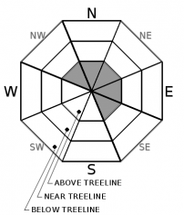
Avalanche Problem 1: Loose Wet
  • Type ?
  • Aspect/Elevation ?
  • Likelihood ?
    Certain
    Very Likely
    Likely
    Possible
    Unlikely
  • Size ?
    Historic
    Very Large
    Large
    Small

Yesterday's rain and warm temperatures should have allowed a thick layer of wet snow to form in most areas. This wet snow likely did not refreeze in most places due to warm overnight temperatures, some continued rain, and consistent cloud cover. Areas above 8000 ft where temperatures dropped below freezing and some of the precipitation fell as snow may have experienced a thin surficial refreeze. Periods of sun this morning combined with daytime warming and continued chances for afternoon showers will quickly melt through any refreeze allowing loose wet avalanches to occur on steep slopes again today. Some of these could entrain enough snow to bury a person. 

Finding supportable snow will mean getting a very early start and heading to higher elevations. Even then the snow may not remain supportable for very long. As soon as the snow starts to get wet and lose its ability to support a person it is time to move to lower angle terrain or get off the wet snow. 

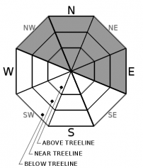
Avalanche Problem 2: Wind Slab
  • Type ?
  • Aspect/Elevation ?
  • Likelihood ?
    Certain
    Very Likely
    Likely
    Possible
    Unlikely
  • Size ?
    Historic
    Very Large
    Large
    Small

Some sensors above 8000 ft along the Sierra Crest showed up to 5 inches of new snow accumulation since yesterday afternoon. SW winds also picked up during the night and may have grown strong enough to transport snow. This combination of wind and new snow could have allowed fresh slabs of wind drifted snow to form on upper elevation leeward aspects. Most of these wind slabs should remain small and inconsequential but a few of them could have grown large enough to pose a problem for backcountry travelers in the most heavily wind-loaded areas.

Identify where wind slabs may exist using clues like cornices above a slope, drifts of new snow, or wind created surface textures. Use this information to adjust your travel plans to account for potentially problematic wind slabs

Avalanche Problem 3: Wet Slab
  • Type ?
  • Aspect/Elevation ?
  • Size ?
    Historic
    Very Large
    Large
    Small

Data indicates that the buried surface hoar layer is starting to assimilate into the snowpack and it is gaining strength. Still, with all of the uncertainty associated with forecasting wet slab avalanches, this problem will remain a concern for a little while longer. If a wet slab avalanche does occur it could involve enough snow to bury or injure a person.

Using timing and terrain to avoid wet snow and/or steep terrain can help avoid wet slabs.

recent observations

Observers on Jakes Peak and Mt. Tallac reported deep wet snow at all elevations before 10 am. The snowpack became unsupportable between 10 and 11 am.

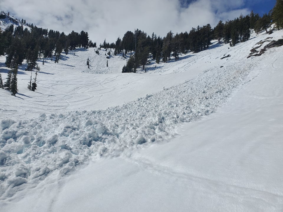
On Mt. Tallac numerous recent loose wet avalanches had occurred and some of them involved enough wet snow to bury a person (D2).

Weather and CURRENT CONDITIONS
weather summary

Yesterday afternoon rain and snow showers across the area yielded .1 to .3 inches of precipitation with sensors near Echo Summit reporting up to .5 inches of water. Below 7500 this precipitation fell as rain. Between 7500 and 8500 areas received a mix of rain and snow with places reporting 1 to 3 inches of snow. Above 8500 ft. most of it fell as snow with some upper elevation sensors reporting up to 5 inches of new snow. The clouds lingered through the night and temperatures above 8000 ft. did manage to dip below freezing in most places. The forecast calls for partly cloudy skies with the potential for periods of sun this morning and increasing clouds with a chance of more showers this afternoon. Snow levels should rise to around 8000 ft. A weak system passing north of the area tonight and tomorrow should bring slightly cooler temperatures and some clouds tonight and tomorrow morning.

CONDITIONS ALONG THE SIERRA CREST BETWEEN 8200 FT. AND 9200 FT. IN THE LAST 24 HOURS
6am temperature: 27 to 33 deg. F.
Max. temperature: 41 to 46 deg. F.
Average ridgetop wind direction: Variable between NE and SW yesterday. WSW since midnight
Average ridgetop wind speed: 10 mph
Maximum ridgetop wind gust: 29 mph
New snowfall: below 8000 ft: rain .2 to .3 inches | Above 8000 ft: snow 2 to 5 inches
Total snow depth: 54 to 77 inches
Two-Day Mountain Weather Forecast Produced in partnership with the Reno NWS
For 7000 ft. to 8000 ft.
Saturday Saturday Night Sunday
Weather: Partly cloudy. Isolated showers in the afternoon. Snow levels 7000 feet increasing to 8000 feet in the afternoon. Chance of precipitation is 15%. Mostly cloudy then becoming partly cloudy. Snow levels 8000 feet decreasing to 7000 feet after midnight. Chance of precipitation is 5%. Partly cloudy then becoming sunny. Snow levels 7000 feet. Chance of precipitation is 10%.
Temperatures: 44 to 50 deg. F. 26 to 31 deg. F. 43 to 49 deg. F.
Mid Slope Winds: West 5 to 15 mph. Gusts to 25 mph in the afternoon. Southwest around 15 mph with gusts to 25 mph. Southwest around 15 mph with gusts up to 25 mph.
Expected snowfall: No accumulation. | SWE = trace amounts. No accumulation. | SWE = none. No accumulation. | SWE = none.
For 8000 ft. to 9000 ft.
Saturday Saturday Night Sunday
Weather: Partly cloudy. Isolated showers in the afternoon. Snow levels 7000 feet increasing to 8000 feet in the afternoon. Chance of precipitation is 15%. Mostly cloudy then becoming partly cloudy. Snow levels 8000 feet decreasing to 7000 feet after midnight. Chance of precipitation is 5%. Partly cloudy then becoming sunny. Snow levels 7000 feet. Chance of precipitation is 10%.
Temperatures: 38 to 44 deg. F. 22 to 27 deg. F. 37 to 43 deg. F.
Ridge Top Winds: West 15 to 25 mph. Southwest 15 to 20 mph with gusts to 30 mph. Southwest 15 to 20 mph with gusts to 30 mph.
Expected snowfall: No accumulation. | SWE = trace amounts. No accumulation. | SWE = none. No accumulation. | SWE = none.
Disclaimer

This avalanche forecast is provided through a partnership between the Tahoe National Forest and the Sierra Avalanche Center. This forecast covers the Central Sierra Nevada Mountains between Yuba Pass on the north and Ebbetts Pass on the south. Click here for a map of the forecast area. This forecast applies only to backcountry areas outside established ski area boundaries. This forecast describes general avalanche conditions and local variations always occur. This forecast expires 24 hours after the posted time unless otherwise noted. The information in this forecast is provided by the USDA Forest Service who is solely responsible for its content.

For a recorded version of the avalanche forecast call (530) 587-3558 x258