THIS AVALANCHE FORECAST EXPIRED ON April 29, 2020 @ 6:47 am
Avalanche Forecast published on April 28, 2020 @ 6:47 am
Issued by Brandon Schwartz - Tahoe National Forest

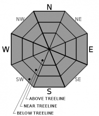
Once the surface crust from last night's refreeze melts away, a loose wet avalanche problem will be present. Cornice failures remain an additional hazard. MODERATE avalanche danger will exist today at all elevations.

2. Moderate

?

Above Treeline
Heightened avalanche conditions on specific terrain features. Evaluate snow and terrain carefully; identify features of concern.

2. Moderate

?

Near Treeline
Heightened avalanche conditions on specific terrain features. Evaluate snow and terrain carefully; identify features of concern.

2. Moderate

?

Below Treeline
Heightened avalanche conditions on specific terrain features. Evaluate snow and terrain carefully; identify features of concern.
    Heightened avalanche conditions on specific terrain features. Evaluate snow and terrain carefully; identify features of concern.
Avalanche Problem 1: Loose Wet
  • Type ?
  • Aspect/Elevation ?
  • Likelihood ?
    Certain
    Very Likely
    Likely
    Possible
    Unlikely
  • Size ?
    Historic
    Very Large
    Large
    Small

Air temperatures were really warm and well above freezing last night. A weak snow surface refreeze driven from radiational cooling of the snowpack is expected to have occurred under mostly clear skies. The relatively thin and superficial melt-freeze crust is expected to be thickest on open slopes and thinner to possibly nonexistent under forest canopy. Once this surface crust melts away the residual deep wet snow below it will be exposed. This exposed deep wet snow will be prone to loose wet avalanches on all aspects and at all elevations. Avalanche size is expected at D1 to D2, depending on what the terrain is capable of producing.

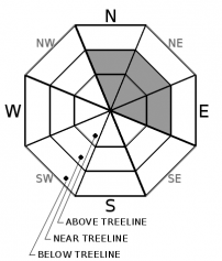
Avalanche problems will develop quickest on E-SE-S aspects, followed by a relatively slower onset on the other aspects. This avalanche problem can be avoided by choosing not to travel in or below avalanche terrain once the surface crust has melted to the point that it is no longer supportable. Use aspect and slope angle to your advantage.

Avalanche Problem 2: Cornice
  • Type ?
  • Aspect/Elevation ?
  • Likelihood ?
    Certain
    Very Likely
    Likely
    Possible
    Unlikely
  • Size ?
    Historic
    Very Large
    Large
    Small

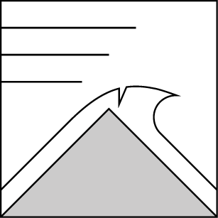
Cornices that exist along many ridgelines will continue to collapse today. Large falling blocks of snow could injure a person on their own and may entrain more wet snow or trigger a loose wet avalanche when they impact the slope below.

Cornices frequently break farther back from their edges than expected. Cornices can also fail at unexpected times. Stay far back from the edges of cornices while on ridgetops and avoid travel underneath cornices.

recent observations

* Spring melt-freeze conditions exist on all aspects across the forecast area.

* Observations made yesterday on Mt. Houghton (Mount Rose area) and near Forestdale Divide (Carson Pass area) reported a decent snow surface refreeze from the night before. Snow surface conditions remained supportable during the morning hours with a thin layer of melted wet snow over melt-freeze crust on all aspects.

* Large chunks of cornice fall continue to occur from the locations where large cornices exist.

Weather and CURRENT CONDITIONS
weather summary

It's going to be a warm one out there today with sunny skies as high pressure moves overhead. Well above average air temperatures for today will last into tomorrow. A weather system passing by to the north tomorrow will affect wind and cloud cover. Light to moderate speed SW ridgetop winds for today will be on the increase tonight, tomorrow, and Thursday. Cloud cover is expected to increase tomorrow afternoon.

CONDITIONS ALONG THE SIERRA CREST BETWEEN 8200 FT. AND 9200 FT. IN THE LAST 24 HOURS
6am temperature: 39 to 49 deg. F.
Max. temperature: 50 to 60 deg. F.
Average ridgetop wind direction: SW
Average ridgetop wind speed: 16 mph
Maximum ridgetop wind gust: 36 mph
New snowfall: 0 inches
Total snow depth: 39 to 67 inches
Two-Day Mountain Weather Forecast Produced in partnership with the Reno NWS
For 7000 ft. to 8000 ft.
Tuesday Tuesday Night Wednesday
Weather: Sunny. Snow levels 11500 feet. Chance of precipitation is 5%. Clear. Snow levels 12000 feet. Chance of precipitation is 5%. Partly cloudy then becoming mostly cloudy. Snow levels 11500 feet. Chance of precipitation is 5%.
Temperatures: 66 to 72. deg. F. 40 to 46. deg. F. 65 to 70. deg. F.
Mid Slope Winds: Light winds. Light winds becoming southwest around 15 mph with gusts to 25 mph after midnight. Southwest 15 to 20 mph. Gusts up to 25 mph increasing to 35 mph in the afternoon.
Expected snowfall: No accumulation. | SWE = none. No accumulation. | SWE = none. No accumulation. | SWE = none.
For 8000 ft. to 9000 ft.
Tuesday Tuesday Night Wednesday
Weather: Sunny. Snow levels 11500 feet. Chance of precipitation is 5%. Clear. Snow levels 12000 feet. Chance of precipitation is 5%. Partly cloudy then becoming mostly cloudy. Snow levels 11500 feet. Chance of precipitation is 5%.
Temperatures: 60 to 66. deg. F. 38 to 43. deg. F. 60 to 66. deg. F.
Ridge Top Winds: Light winds becoming southwest around 15 mph with gusts to 25 mph in the afternoon. Southwest 15 to 20 mph. Gusts up to 25 mph increasing to 40 mph after midnight. Southwest 15 to 30 mph with gusts to 50 mph.
Expected snowfall: No accumulation. | SWE = none. No accumulation. | SWE = none. No accumulation. | SWE = none.
Disclaimer

This avalanche forecast is provided through a partnership between the Tahoe National Forest and the Sierra Avalanche Center. This forecast covers the Central Sierra Nevada Mountains between Yuba Pass on the north and Ebbetts Pass on the south. Click here for a map of the forecast area. This forecast applies only to backcountry areas outside established ski area boundaries. This forecast describes general avalanche conditions and local variations always occur. This forecast expires 24 hours after the posted time unless otherwise noted. The information in this forecast is provided by the USDA Forest Service who is solely responsible for its content.

For a recorded version of the avalanche forecast call (530) 587-3558 x258