THIS AVALANCHE FORECAST EXPIRED ON April 7, 2020 @ 6:59 am
Avalanche Forecast published on April 6, 2020 @ 6:59 am
Issued by Andy Anderson - Tahoe National Forest - Sierra Avalanche Center

The storm has left unstable slabs of wind drifted snow and softer slabs of storm snow on steep slopes in both exposed and sheltered terrain. Recreating on slopes where these problems exist could trigger avalanches. Give the snowpack time to adjust to the new load before heading onto steep slopes. Plenty of nice snow exists on lower angle sheltered terrain. Expect CONSIDERABLE avalanche danger near and above treeline with MODERATE danger below treeline.

3. Considerable

?

Above Treeline
Dangerous avalanche conditions. Careful snowpack evaluation, cautious route-finding and conservative decision-making essential.

3. Considerable

?

Near Treeline
Dangerous avalanche conditions. Careful snowpack evaluation, cautious route-finding and conservative decision-making essential.

2. Moderate

?

Below Treeline
Heightened avalanche conditions on specific terrain features. Evaluate snow and terrain carefully; identify features of concern.
    Dangerous avalanche conditions. Careful snowpack evaluation, cautious route-finding and conservative decision-making essential.
Avalanche Problem 1: Wind Slab
  • Type ?
  • Aspect/Elevation ?
  • Likelihood ?
    Certain
    Very Likely
    Likely
    Possible
    Unlikely
  • Size ?
    Historic
    Very Large
    Large
    Small

Fresh slabs of wind drifted snow exist on wind-loaded and cross-loaded NW-N-NE-E-SE aspects. These wind slabs will remain fragile today. If people venture onto steep wind-loaded slopes, they will likely trigger wind slab avalanches. Wind slab avalanches could break several feet deep and could entrain enough snow to bury a person or maybe even a car. In some isolated areas, it is not impossible for these avalanches to break below the old snow surface on older weak snow. Sun on wind-loaded slopes could make wind slabs easier to trigger. Large fragile cornices also lurk above many wind-loaded slopes.

Look out for cornices above a slope, convex pillows of wind-drifted snow, scoured ridgetops, and wind created surface textures. Use this information to plan a route to avoid areas where dangerous wind slabs may lurk. Soft cold snow will exist in abundance on lower angle slopes in areas sheltered from the wind.

Avalanche Problem 2: Storm Slab
  • Type ?
  • Aspect/Elevation ?
  • Likelihood ?
    Certain
    Very Likely
    Likely
    Possible
    Unlikely
  • Size ?
    Historic
    Very Large
    Large
    Small

People recreating on steep slopes in sheltered terrain could still trigger avalanches that involve slabs of storm snow 1 to 2 ft deep. These storm slab avalanches could entrain enough snow to bury a person. They could break on weaknesses within the storm snow or may fail on the old snow surfaces. In some isolated areas, they may overload weak layers below the old snow surface. Similar to the wind slabs above, sun on slopes could make storm slabs easier to trigger.

Since the new snow may look soft and smooth, storm slabs can be hard to identify. Recent avalanche activity, shooting cracks, and test slope failures can all help identify which slopes may hold unstable storm slabs. Storm slabs tend to gain strength relatively quickly so being patient and waiting a couple of days to travel on steeper slopes can also help avoid the storm slab problem. 


recent observations

Yesterday morning skiers triggered storm slab avalanches in Munchkins that measured about 6 inches in depth. Later in the day, skier-triggered storm slabs on test slopes on Silver Peak (mid-day) and Trestle Peak (afternoon) measured 12 to 18 inches in depth. On Silver Peak, the storm slabs failed just above the old snow surface and on Trestle Peak they failed just below the old snow surface. Observers also reported upside-down layering and skier triggered shooting cracks in the storm snow on Pickett Peak. Small storm slab activity that occurred Saturday evening was also reported from near Frog Lake Cliffs (near Castle Peak).

A small wind loaded test slope on Silver Peak released as a skier approached the slope yesterday. Observers also reported widespread cracking on wind drifted test slopes on Powderhouse Peak. Small wind slab avalanches that occurred on Saturday evening were also reported on Andesite Peak. 

Skier triggered loose dry sluffs occurred before 10 am yesterday in Deep Creek.  

Weather and CURRENT CONDITIONS
weather summary

The storm deposited another 18 to 24 inches of new snow along the Sierra Crest in the last 24 hrs. East of Lake Tahoe sensors reported about 10 to 12 inches. Snowfall started to taper off early this morning and the winds decreased overnight. A mix of sun and clouds this morning should give way to snow showers this afternoon. Showery weather should continue through tomorrow. Light snow accumulations are possible today, tonight, and tomorrow. 

CONDITIONS ALONG THE SIERRA CREST BETWEEN 8200 FT. AND 9200 FT. IN THE LAST 24 HOURS
6am temperature: 15 to 23 deg. F.
Max. temperature: 24 to 29 deg. F.
Average ridgetop wind direction: SW
Average ridgetop wind speed: 20 to 30 mph
Maximum ridgetop wind gust: 101 mph
New snowfall: 18 to 24 inches
Total snow depth: 75 to 98 inches
Two-Day Mountain Weather Forecast Produced in partnership with the Reno NWS
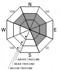
For 7000 ft. to 8000 ft.
Monday Monday Night Tuesday
Weather: Mostly cloudy. Snow likely in the morning, then snow showers in the afternoon. Snow levels below 7000 feet. Chance of precipitation is 75%. Mostly cloudy. Chance of snow showers in the evening, then chance of snow after midnight. Snow levels below 7000 feet. Chance of precipitation is 50%. Mostly cloudy. Chance of snow in the morning, then chance of snow showers in the afternoon. Snow levels below 7000 feet. Chance of precipitation is 40%.
Temperatures: 31 to 36 deg. F. 18 to 24 deg. F. 35 to 41 deg. F.
Mid Slope Winds: Light winds. Light winds. Light winds.
Expected snowfall: 80% probability of 1 to 3 inches. 20% probability of 3 to 5 inches. | SWE = up to 0.20 inch. 80% probability of 1 to 3 inches. 20% probability of 3 to 5 inches. | SWE = up to 0.20 inch. 80% probability up to 1 inch. 20% probability of 1 to 3 inches. | SWE = less than 0.10 inch.
For 8000 ft. to 9000 ft.
Monday Monday Night Tuesday
Weather: Mostly cloudy. Snow likely in the morning, then snow showers in the afternoon. Snow levels below 7000 feet. Chance of precipitation is 80%. Mostly cloudy. Chance of snow showers in the evening, then chance of snow after midnight. Snow levels below 7000 feet. Chance of precipitation is 50%. Mostly cloudy. Chance of snow in the morning, then chance of snow showers in the afternoon. Snow levels below 7000 feet. Chance of precipitation is 45%.
Temperatures: 25 to 31 deg. F. 15 to 20 deg. F. 29 to 35 deg. F.
Ridge Top Winds: Southwest around 15 mph in the morning becoming light. Light winds. Light winds becoming east around 15 mph in the afternoon.
Expected snowfall: 80% probability of 1 to 3 inches. 20% probability of 3 to 5 inches. | SWE = up to 0.20 inch. 80% probability of 1 to 3 inches. 20% probability of 3 to 5 inches. | SWE = up to 0.20 inch. 80% probability up to 1 inch. 20% probability of 1 to 3 inches. | SWE = less than 0.10 inch.
Disclaimer

This avalanche forecast is provided through a partnership between the Tahoe National Forest and the Sierra Avalanche Center. This forecast covers the Central Sierra Nevada Mountains between Yuba Pass on the north and Ebbetts Pass on the south. Click here for a map of the forecast area. This forecast applies only to backcountry areas outside established ski area boundaries. This forecast describes general avalanche conditions and local variations always occur. This forecast expires 24 hours after the posted time unless otherwise noted. The information in this forecast is provided by the USDA Forest Service who is solely responsible for its content.

For a recorded version of the avalanche forecast call (530) 587-3558 x258