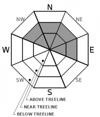
THIS AVALANCHE FORECAST EXPIRED ON December 15, 2020 @ 6:50 am
Avalanche Forecast published on December 14, 2020 @ 6:50 am
Issued by Brandon Schwartz - Tahoe National Forest

The current avalanche situation is both dangerous and complex. Slabs of wind drifted snow and a significant new snow load overlying old weak snow means the possibility of encountering an avalanche in lots of different areas today both above and below treeline. Today is not a day to go big. Scale back terrain choices and slope angles. CONSIDERABLE avalanche danger exists at all elevations.

3. Considerable

?

Above Treeline
Dangerous avalanche conditions. Careful snowpack evaluation, cautious route-finding and conservative decision-making essential.

3. Considerable

?

Near Treeline
Dangerous avalanche conditions. Careful snowpack evaluation, cautious route-finding and conservative decision-making essential.

3. Considerable

?

Below Treeline
Dangerous avalanche conditions. Careful snowpack evaluation, cautious route-finding and conservative decision-making essential.
    Dangerous avalanche conditions. Careful snowpack evaluation, cautious route-finding and conservative decision-making essential.
Avalanche Problem 1: Wind Slab
  • Type ?
  • Aspect/Elevation ?
  • Likelihood ?
    Certain
    Very Likely
    Likely
    Possible
    Unlikely
  • Size ?
    Historic
    Very Large
    Large
    Small

New snow and gale force SW winds over the past 24 hours increased the existing wind slab problem. Unstable wind slabs were reported yesterday from numerous areas. A small skier triggered wind slab avalanche was intentionally triggered yesterday near Yuba Pass near treeline on a NE aspect at around 7,700'. In many areas, especially near treeline, slabs of wind drifted snow were deposited on top of weak faceted (sugary) snow. These wind slabs are expected to continue to be reactive today. Problematic wind slabs are widespread near treeline and above treeline on NW-N-NE-E aspects across the forecast area.

Any slopes near ridgetops where blowing and drifting snow have deposited are suspect. Any slopes with newly formed cornices or drifted pillows of snow along the upper portion of the slope are likely to hold unstable wind slabs. Snow surface cracking is a sign of unstable snow in the immediate area. Use low angle or wind protected terrain to avoid the areas where wind drifted snow is depositing as a wind slab. Take care not to venture onto slopes with a persistent slab problem while trying to avoid the wind slab problem.

 Small wind slab avalanche intentionally triggered yesterday near Yuba Pass, CA.

Avalanche Problem 2: Persistent Slab
  • Type ?
  • Aspect/Elevation ?
  • Likelihood ?
    Certain
    Very Likely
    Likely
    Possible
    Unlikely
  • Size ?
    Historic
    Very Large
    Large
    Small

Evidence of the expected persistent slab avalanche problem began to show yesterday afternoon. The long dry spell from Nov 18 to Dec 11 caused the existing snowpack to weaken and turn sugary from the faceting process. This weak snow is widespread below treeline and near treeline on W-NW-N-NE-E aspects. It has been noted in isolated areas above treeline as well. The snowfall from the past 24 hours is expected to have brought this weak snow very close to the point of failure. The added weight of a person may be all that is needed to trigger an avalanche. Persistent slab avalanches will break in the snowpack below the old/new snow interface and could have wide propagation, wrapping around corners and other terrain features that often confine wind slabs and storm slabs. Persistent slab avalanches can be triggered in low angle terrain from a distance to the side, above, or from below (remote triggering). In some cases with this type of avalanche problem, an avalanche may occur on a slope that already has tracks on it.

Staying on wind protected slopes in the trees is not a tactic for avoiding persistent slabs. It is a tactic for avoiding wind slabs. You have to route plan to manage both today. The situation is now complex with travel in avalanche terrain difficult to manage. The easy answer is to pull back into low angle, conservative terrain that is less than 30 degrees in slope angle and without steeper slopes adjacent or above.

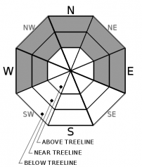
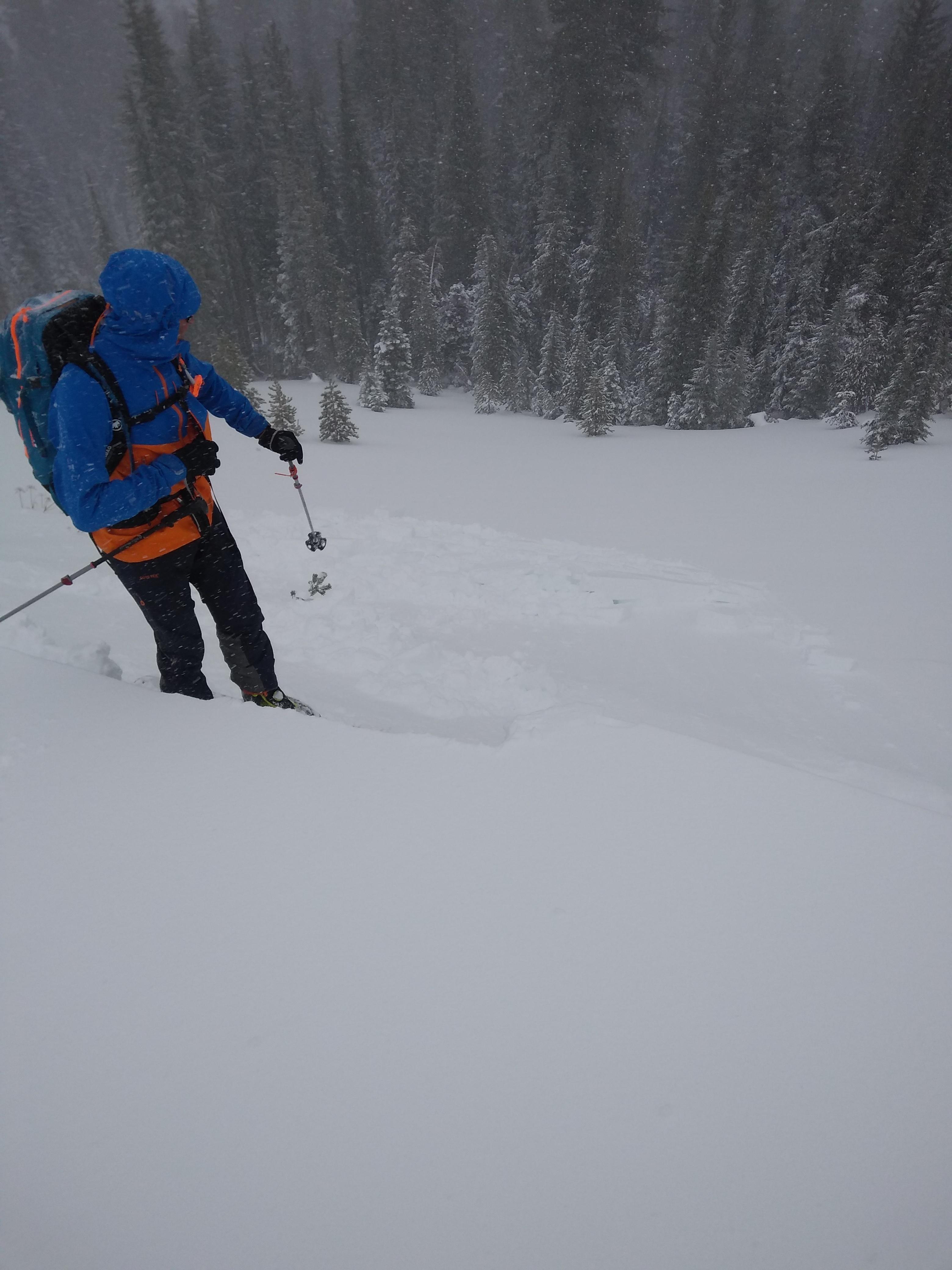
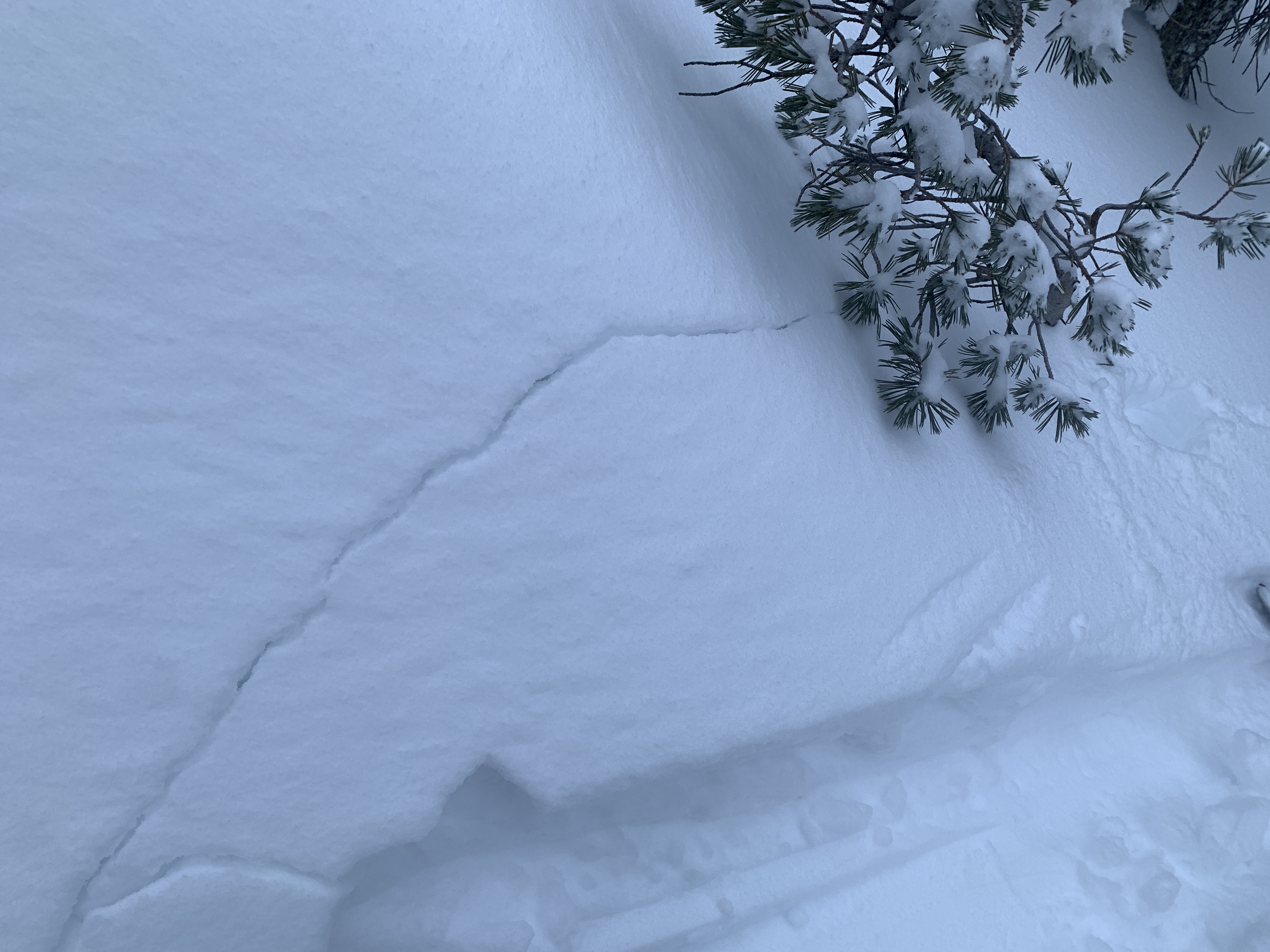
 Shooting crack failing on old faceted snow below 8 inches of new snow load in the Mt Rose zone, NV.

recent observations

* Small wind slab avalanches were reported yesterday from Yuba Pass and on Saturday from the Carson Pass area. Significant amounts of drifting snow and signs of wind slab development were reported yesterday from numerous other areas.

* Weak faceted (sugary) snow in the mid and upper snowpack is widespread below treeline, at treeline, and in some areas above treeline on W-NW-N-NE-E aspects. This weak snow is in poor condition to handle new snow loading. This weak faceted snow is now named the Dec 11 persistent weak layer. Snow surface cracking and unstable snowpit test results were reported yesterday on this weak layer.

Weather and CURRENT CONDITIONS
weather summary

Snowfall tapered off early this morning with yesterday's storm system exiting the area. Snowfall amounts range from 6 to 14 inches across the forecast area. Most upper elevation areas received 8 to 12 inches with some standouts to 14 inches. Partial clearing is expected today for a mix of sun and cloud cover. Ridgetop winds are shifting from SW to NE as of 5 am. Winds speeds have decreased and are expected to remain light to moderate in speed today. A period of clear skies is forecast for tonight. Cloud cover is forecast to increase tomorrow and Wednesday. The next storm system is expected Wednesday night.

CONDITIONS ALONG THE SIERRA CREST BETWEEN 8200 FT. AND 9200 FT. IN THE LAST 24 HOURS
6am temperature: 18 to 22 deg. F.
Max. temperature: 28 to 33 deg. F.
Average ridgetop wind direction: SW
Average ridgetop wind speed: 48 mph
Maximum ridgetop wind gust: 108 mph
New snowfall: 8 to 14 inches
Total snow depth: 23 to 30 inches
Two-Day Mountain Weather Forecast Produced in partnership with the Reno NWS
For 7000 ft. to 8000 ft.
Monday Monday Night Tuesday
Weather: Mostly cloudy then becoming partly cloudy. Snow levels below 7000 feet. Chance of precipitation is 5%. Partly cloudy then becoming clear. Snow levels below 7000 feet. Chance of precipitation is 0%. Sunny then becoming partly cloudy. Snow levels below 7000 feet. Chance of precipitation is 5%.
Temperatures: 26 to 31. deg. F. 14 to 20. deg. F. 37 to 42. deg. F.
Mid Slope Winds: West up to 10 mph in the morning becoming northeast. Gusts to 20 mph in the morning. East up to 10 mph. Light becoming west up to 10 mph in the afternoon.
Expected snowfall: No accumulation. | SWE = none. No accumulation. | SWE = none. No accumulation. | SWE = none.
For 8000 ft. to 9000 ft.
Monday Monday Night Tuesday
Weather: Mostly cloudy then becoming partly cloudy. Snow levels below 7000 feet. Chance of precipitation is 5%. Partly cloudy then becoming clear. Snow levels below 7000 feet. Chance of precipitation is 0%. Sunny then becoming partly cloudy. Snow levels below 7000 feet. Chance of precipitation is 5%.
Temperatures: 22 to 28. deg. F. 14 to 19. deg. F. 33 to 39. deg. F.
Ridge Top Winds: West 10 to 20 mph in the morning becoming northeast. East 10 to 20 mph with gusts to 35 mph. Southeast 10 to 15 mph becoming southwest with gusts to 25 mph in the afternoon.
Expected snowfall: No accumulation. | SWE = none. No accumulation. | SWE = none. No accumulation. | SWE = none.
Disclaimer

This avalanche forecast is provided through a partnership between the Tahoe National Forest and the Sierra Avalanche Center. This forecast covers the Central Sierra Nevada Mountains between Yuba Pass on the north and Ebbetts Pass on the south. Click here for a map of the forecast area. This forecast applies only to backcountry areas outside established ski area boundaries. This forecast describes general avalanche conditions and local variations always occur. This forecast expires 24 hours after the posted time unless otherwise noted. The information in this forecast is provided by the USDA Forest Service who is solely responsible for its content.

For a recorded version of the avalanche forecast call (530) 587-3558 x258