


For 7000 ft. to 8000 ft.
| Tuesday | Tuesday Night | Wednesday | |
|---|---|---|---|
| Weather: | Sunny then becoming partly cloudy. Snow levels below 7000 feet. Chance of precipitation is 0%. | Partly cloudy. Snow levels 7000 feet. Chance of precipitation is 0%. | Partly cloudy then becoming mostly cloudy. Snow levels below 7000 feet. Chance of precipitation is 5%. |
| Temperatures: | 37 to 42. deg. F. | 21 to 27. deg. F. | 39 to 44. deg. F. |
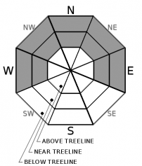
| Mid Slope Winds: | North 10 to 15 mph in the morning becoming west. Gusts to 25 mph. | West around 10 mph. | Light winds becoming west 10 to 20 mph with gusts up to 30 mph in the afternoon. |
| Expected snowfall: | No accumulation. | SWE = none. | No accumulation. | SWE = none. | No accumulation. | SWE = none. |
For 8000 ft. to 9000 ft.
| Tuesday | Tuesday Night | Wednesday | |
|---|---|---|---|
| Weather: | Sunny then becoming partly cloudy. Snow levels below 7000 feet. Chance of precipitation is 0%. | Partly cloudy. Snow levels 7000 feet. Chance of precipitation is 0%. | Partly cloudy then becoming mostly cloudy. Snow levels below 7000 feet. Chance of precipitation is 5%. |
| Temperatures: | 33 to 39. deg. F. | 20 to 26. deg. F. | 35 to 41. deg. F. |
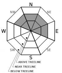
| Ridge Top Winds: | Northeast 15 to 30 mph becoming west in the afternoon. Gusts to 50 mph in the morning. | West 15 to 25 mph with gusts up to 40 mph. | Southwest 15 to 25 mph. Gusts up to 40 mph increasing to 60 mph in the afternoon. |
| Expected snowfall: | No accumulation. | SWE = none. | No accumulation. | SWE = none. | No accumulation. | SWE = none. |


