THIS AVALANCHE FORECAST EXPIRED ON December 3, 2020 @ 6:49 am
Avalanche Forecast published on December 2, 2020 @ 6:49 am
Issued by Steve Reynaud - Tahoe National Forest

If your heading into the backcountry, be prepared for early season conditions with a thin and variable snowpack.  LOW avalanche danger exists with avalanche activity unlikely.  Normal caution is advised.  

1. Low

?

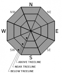
Above Treeline
Generally safe avalanche conditions. Watch for unstable snow on isolated terrain features.

1. Low

?

Near Treeline
Generally safe avalanche conditions. Watch for unstable snow on isolated terrain features.

1. Low

?

Below Treeline
Generally safe avalanche conditions. Watch for unstable snow on isolated terrain features.
    Generally safe avalanche conditions. Watch for unstable snow on isolated terrain features.
Avalanche Problem 1: Normal Caution
  • Type ?
  • Aspect/Elevation ?
  • Likelihood ?
    Certain
    Very Likely
    Likely
    Possible
    Unlikely
  • Size ?
    Historic
    Very Large
    Large
    Small

We have 1-2 feet of a useable and mostly supportable snowpack.  Lots of obstacles are present with early season conditions throughout the forecast region.  Variable snow conditions exist with recent strong winds scouring most exposed areas creating wind crusts.  Soft unconsolidated snow can still be found in wind protected northerly terrain.  Now is still a great time to prepare for the winter.  Get all your gear together, make sure everything is in working order, and get out and practice with your partners.  Normal caution is advised if traveling in the backcountry. 

recent observations

1-2 feet of a supportable snowpack exists on northerly aspects above 8600' in the Mt. Rose area, above 7000' along the northern Sierra Crest, and above 8000' along the southern Sierra Crest.  Southerly aspects have seen snow melt and loss with many areas back down to dirt.  Variable snow conditions are found with recent E wind scouring in open near and above treeline areas.  The faceting process continues with clear skies, cold nights, and low sun angles.  This is most apparent near the surface of the snowpack with near surface facets existing on wind protected northerly aspects.  These near surface facets along with some slightly buried surface hoar will have to be monitored and could present future problems when we get our next storm cycle.

Weather and CURRENT CONDITIONS
weather summary

Sunny skies continue with light winds at upper elevations and calm conditions near lake level.  High pressure is firmly in place with temperature inversions setting up with colder air in the valleys and warmer air at higher elevations.  Truckee and South Lake Tahoe airports have temperatures this morning in the high teens with the Sierra Crest (8200-9200') in the mid 30's to low 40's.  The main level storm track will remain well north of our area at least into the weekend.  Some high clouds could develop on Thursday and again over the weekend as storms pass by north of CA.  

CONDITIONS ALONG THE SIERRA CREST BETWEEN 8200 FT. AND 9200 FT. IN THE LAST 24 HOURS
6am temperature: 35 to 44 deg. F.
Max. temperature: 41 to 47 deg. F.
Average ridgetop wind direction: NE
Average ridgetop wind speed: 15 to 25 mph
Maximum ridgetop wind gust: 41 mph
New snowfall: 0 inches
Total snow depth: 14 to 18 inches
Two-Day Mountain Weather Forecast Produced in partnership with the Reno NWS
For 7000 ft. to 8000 ft.
Wednesday Wednesday Night Thursday
Weather: Sunny. Snow levels below 7000 feet increasing to 7000 feet in the afternoon. Chance of precipitation is 0%. Clear. Snow levels below 7000 feet. Chance of precipitation is 0%. Partly cloudy then becoming sunny. Snow levels below 7000 feet. Chance of precipitation is 0%.
Temperatures: 40 to 46. deg. F. 21 to 27. deg. F. 38 to 44. deg. F.
Mid Slope Winds: Light winds. Light winds. Light winds.
Expected snowfall: No accumulation. | SWE = none. No accumulation. | SWE = none. No accumulation. | SWE = none.
For 8000 ft. to 9000 ft.
Wednesday Wednesday Night Thursday
Weather: Sunny. Snow levels below 7000 feet increasing to 7500 feet in the afternoon. Chance of precipitation is 0%. Clear. Snow levels below 7000 feet. Chance of precipitation is 0%. Partly cloudy then becoming sunny. Snow levels below 7000 feet. Chance of precipitation is 0%.
Temperatures: 38 to 44. deg. F. 21 to 26. deg. F. 34 to 40. deg. F.
Ridge Top Winds: East to southeast winds 10 to 20 mph. Southeast around 15 mph. Gusts up to 25 mph in the evening. Southeast winds to 10 mph.
Expected snowfall: No accumulation. | SWE = none. No accumulation. | SWE = none. No accumulation. | SWE = none.
Disclaimer

This avalanche forecast is provided through a partnership between the Tahoe National Forest and the Sierra Avalanche Center. This forecast covers the Central Sierra Nevada Mountains between Yuba Pass on the north and Ebbetts Pass on the south. Click here for a map of the forecast area. This forecast applies only to backcountry areas outside established ski area boundaries. This forecast describes general avalanche conditions and local variations always occur. This forecast expires 24 hours after the posted time unless otherwise noted. The information in this forecast is provided by the USDA Forest Service who is solely responsible for its content.

For a recorded version of the avalanche forecast call (530) 587-3558 x258