THIS AVALANCHE FORECAST EXPIRED ON December 22, 2020 @ 6:55 am
Avalanche Forecast published on December 21, 2020 @ 6:55 am
Issued by Brandon Schwartz - Tahoe National Forest

Spatial variability for the persistent slab avalanche problem is increasing. This makes it more difficult to observe evidence of instability prior to triggering a persistent slab avalanche. Triggering a large avalanche remains possible, especially near treeline and below treeline. Additionally, small unstable slabs of wind drifted snow (wind slabs) exist above treeline and near treeline. MODERATE avalanche danger continues at all elevations.

2. Moderate

?

Above Treeline
Heightened avalanche conditions on specific terrain features. Evaluate snow and terrain carefully; identify features of concern.

2. Moderate

?

Near Treeline
Heightened avalanche conditions on specific terrain features. Evaluate snow and terrain carefully; identify features of concern.

2. Moderate

?

Below Treeline
Heightened avalanche conditions on specific terrain features. Evaluate snow and terrain carefully; identify features of concern.
    Heightened avalanche conditions on specific terrain features. Evaluate snow and terrain carefully; identify features of concern.
Avalanche Problem 1: Persistent Slab
  • Type ?
  • Aspect/Elevation ?
  • Likelihood ?
    Certain
    Very Likely
    Likely
    Possible
    Unlikely
  • Size ?
    Historic
    Very Large
    Large
    Small

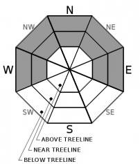
This avalanche problem is found near treeline and below treeline and in isolated areas above treeline on W-NW-N-NE-E aspects. A slab of around 1 foot+ of recent new snow sits on top of a weak layer of sugary, faceted snow. This sugary snow is the Dec 11 persistent weak layer (PWL). Given the current setup, any persistent slab avalanches will likely be large.

Spatial variability is increasing for this avalanche problem. The challenge this presents is finding evidence of instability for the slope(s) of interest prior to triggering an avalanche. While collectively snowpack data from around the forecast area suggests that instability associated with this problem is decreasing on a regional scale, data comes in daily from specific locations where instability is still very much present. Please continue to exercise caution. Cracking, whumpfing (audible snowpack collapse), or snowpit tests provide clues to the presence of instability. Since spatial variability is increasing, do not underestimate the significance of any signs of instability, even if they seem isolated. Limiting exposure to avalanche terrain by using only sub 30 degree angle slopes without steeper connected slopes above or to the side is the easy way to manage this avalanche problem.

Avalanche Problem 2: Wind Slab
  • Type ?
  • Aspect/Elevation ?
  • Likelihood ?
    Certain
    Very Likely
    Likely
    Possible
    Unlikely
  • Size ?
    Historic
    Very Large
    Large
    Small

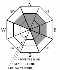
Recent and ongoing SW to W ridgetop wind has drifted small amounts of snow above treeline and near treeline. Small unstable wind slabs exist in these areas on NW-N-NE-E-SE aspects. Slopes below or adjacent to cornice features and/or pillows of wind drifted snow are the most suspect. Move around these areas with caution.

recent observations

* The faceted Dec 11 persistent weak layer (PWL) continues to produce snowpack collapse with audible whumpfing and increasingly variable unstable vs. non-propagating snowpit test results. Spatial variability is increasing for this PWL.

* Small reactive wind slabs were reported yesterday from a variety of near treeline and above treeline locations.

* Surface hoar exists in many areas. Any surface hoar that survives warm air temperatures today and strong winds this afternoon/evening could be buried under light snowfall tonight.

* Snow surface melt is occurring on southerly aspects. Shaded northerly aspects remain unaffected by melt.

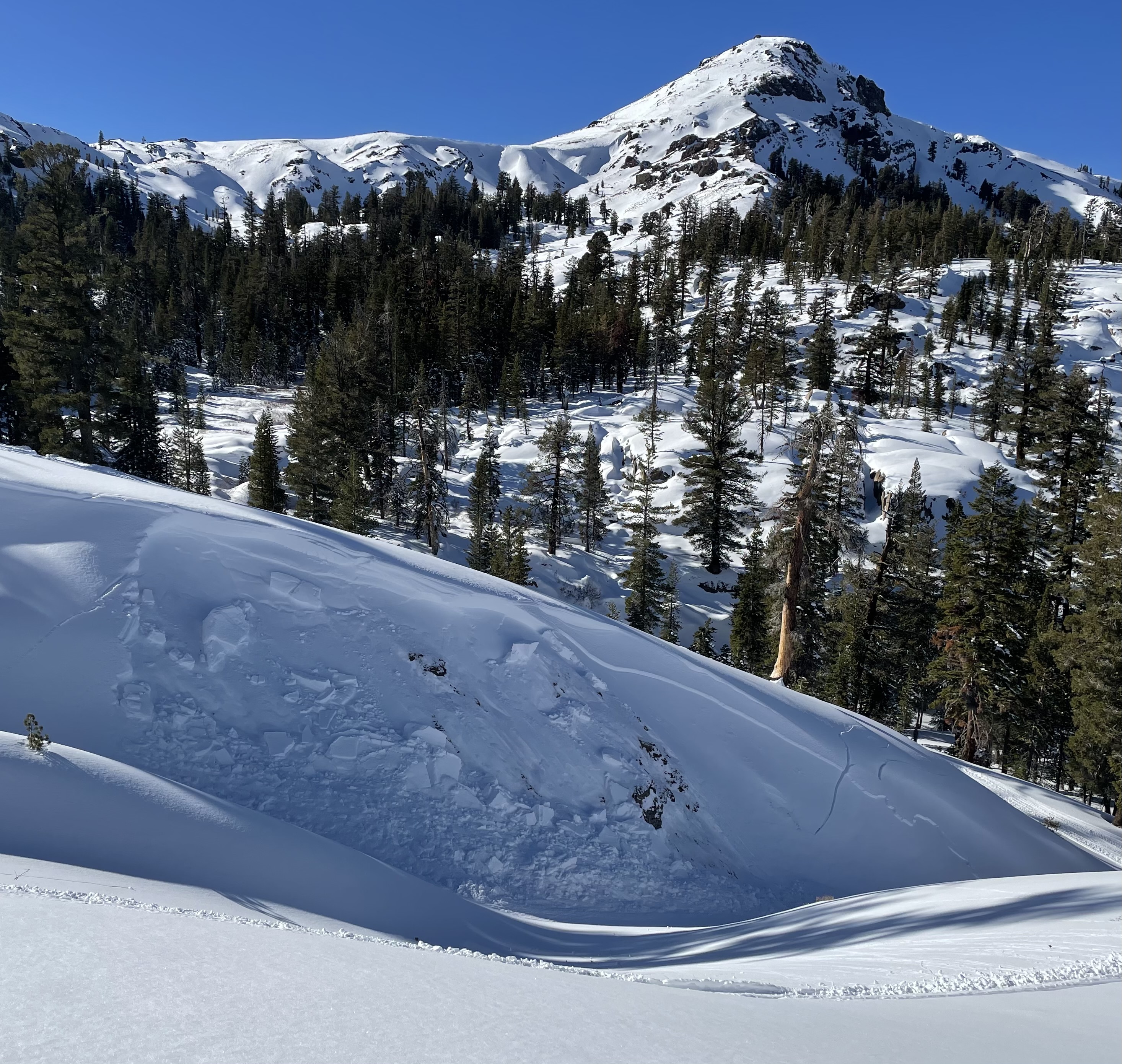
 Reported Saturday from south of Carson Pass, exact occurrence day/time unknown. Small terrain somewhere between The Nipple and Blue Lakes Rd on an N to NE aspect at around 8,200'. Unverified weak layer but this has the signature of a persistent slab avalanche. Shallow wind slab crown on looker's right half likely stepped down to deeper faceted snow on the left side. Long fractures in the snow on the far right side likely go down to faceted snow (Dec 11 PWL).

Weather and CURRENT CONDITIONS
weather summary

Air temperature inversion conditions are in place again this morning with well above freezing air temperatures overnight on the peaks and below freezing air temperatures on the mountain valley floors. Another warm day is forecast at the mid and upper elevations. Winds will increase out of the SW today, becoming strong this afternoon and tonight ahead of an approaching cold front. Very light snowfall is forecast for late tonight/early tomorrow morning, mainly north of Lake Tahoe. A substantial cool down is expected for tomorrow. Ridgetop winds will gradually decrease tomorrow from strong to moderate speed, remaining out of the SW to W. A pair of storms are expected to arrive Dec 25-28.

CONDITIONS ALONG THE SIERRA CREST BETWEEN 8200 FT. AND 9200 FT. IN THE LAST 24 HOURS
6am temperature: 37 to 43 deg. F.
Max. temperature: 45 to 49 deg. F.
Average ridgetop wind direction: Variable
Average ridgetop wind speed: 11 mph
Maximum ridgetop wind gust: 27 mph
New snowfall: 0 inches
Total snow depth: 24 to 31 inches
Two-Day Mountain Weather Forecast Produced in partnership with the Reno NWS
For 7000 ft. to 8000 ft.
Monday Monday Night Tuesday
Weather: Sunny. Snow levels below 7000 feet. Chance of precipitation is 0%. Clear. Snow levels below 7000 feet. Chance of precipitation is 10%. Mostly sunny. Slight chance of snow in the morning. Snow levels below 7000 feet. Chance of precipitation is 20%.
Temperatures: 44 to 49. deg. F. 24 to 30. deg. F. 33 to 38. deg. F.
Mid Slope Winds: Light winds becoming southwest around 15 mph with gusts to 35 mph in the afternoon. Southwest around 15 mph with gusts to 40 mph. Southwest around 15 mph with gusts to 35 mph in the morning becoming light.
Expected snowfall: No accumulation. | SWE = none. Up to 0.5" possible. | SWE = less than 0.10 inch. No accumulation. | SWE = trace amounts.
For 8000 ft. to 9000 ft.
Monday Monday Night Tuesday
Weather: Sunny. Snow levels below 7000 feet. Chance of precipitation is 0%. Clear. Snow levels below 7000 feet. Chance of precipitation is 10%. Mostly sunny. Slight chance of snow in the morning. Snow levels below 7000 feet. Chance of precipitation is 20%.
Temperatures: 41 to 46. deg. F. 23 to 28. deg. F. 30 to 35. deg. F.
Ridge Top Winds: Southwest 15 to 25 mph. Gusts up to 55 mph in the afternoon. Southwest 15 to 30 mph with gusts to 65 mph increasing to 30 to 45 mph with gusts to 85 mph after midnight. Southwest 25 to 35 mph with gusts to 80 mph becoming west 15 to 25 mph with gusts to 50 mph in the afternoon.
Expected snowfall: No accumulation. | SWE = none. Up to 0.5" possible. | SWE = less than 0.10 inch. No accumulation. | SWE = trace amounts.
Disclaimer

This avalanche forecast is provided through a partnership between the Tahoe National Forest and the Sierra Avalanche Center. This forecast covers the Central Sierra Nevada Mountains between Yuba Pass on the north and Ebbetts Pass on the south. Click here for a map of the forecast area. This forecast applies only to backcountry areas outside established ski area boundaries. This forecast describes general avalanche conditions and local variations always occur. This forecast expires 24 hours after the posted time unless otherwise noted. The information in this forecast is provided by the USDA Forest Service who is solely responsible for its content.

For a recorded version of the avalanche forecast call (530) 587-3558 x258