THIS AVALANCHE FORECAST EXPIRED ON December 24, 2020 @ 6:58 am
Avalanche Forecast published on December 23, 2020 @ 6:58 am
Issued by Steve Reynaud - Tahoe National Forest

A shallow and generally weak snowpack structure continues across the forecast region.  The persistent slab and wind slab avalanche problems have become unlikely on a regional scale.  LOW avalanche danger exists at all elevations.

1. Low

?

Above Treeline
Generally safe avalanche conditions. Watch for unstable snow on isolated terrain features.

1. Low

?

Near Treeline
Generally safe avalanche conditions. Watch for unstable snow on isolated terrain features.

1. Low

?

Below Treeline
Generally safe avalanche conditions. Watch for unstable snow on isolated terrain features.
    Generally safe avalanche conditions. Watch for unstable snow on isolated terrain features.
Avalanche Problem 1: Persistent Slab
  • Type ?
  • Aspect/Elevation ?
  • Likelihood ?
    Certain
    Very Likely
    Likely
    Possible
    Unlikely
  • Size ?
    Historic
    Very Large
    Large
    Small

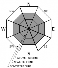
The forecast area has a generally shallow, weak, and highly variable snowpack.  The Dec. 11 persistent weak layer has been gaining strength over time and adjusting to the recent storm snow load on top of it.  Overall, there has been a lack of avalanche activity associated with the Dec 11 weak layer with no reported avalanches in over 5 days.  Signs of instability and unstable snowpack test results have been on the decline for multiple days as well.  All of our data points to this avalanche problem becoming unlikely on a regional scale.  The process of this weak layer gaining strength and rounding will take time and may not occur at the same pace at all locations.   

Whumpfing sounds, cracking, and/or unstable snowpack test results could indicate that this weak layer is still active in your specific area.  Limit exposure to avalanche terrain by having a trip plan, traveling 1 at a time through avalanche terrain, and regrouping well out of run out zones and avalanche terrain.     

Avalanche Problem 2: Wind Slab
  • Type ?
  • Aspect/Elevation ?
  • Likelihood ?
    Certain
    Very Likely
    Likely
    Possible
    Unlikely
  • Size ?
    Historic
    Very Large
    Large
    Small

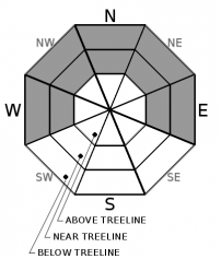
Monday nights strong to gale force SW winds moved snow on to NW-N-NE-E-SE aspects creating small stiff wind slabs in near and above treeline areas.  Reports of minor cracking and a small natural wind slab avalanche were reported yesterday.  Winds shifted to the NE last night and increased into the strong to gale force range.  This will further scour exposed terrain and potentially transport some snow over to SE-S-SW-W aspects.  Limited available snow for transport exists in most areas with many firm and scoured areas potentially causing travel concerns and fall hazards.  Wind slabs are expected to continue to gain strength today with any avalanches expected to be small, D1 in size.  However, in complex terrain, even small avalanches could have increased consequences with secondary exposure and thin snowpack conditions. 

recent observations

*  A small wind slab avalanche was reported from Stevens Peak, in the Carson Pass area.  3 to 4'' thick wind slabs were found in this area with some minor cracking.  Firm wind scoured  snow surfaces were found in near and above treeline areas.

*  Small stiff wind slabs 3 to 4'' thick were also found on Lincoln Ridge at Yuba Pass.  These wind slabs showed minor cracking but were not reactive with dropping cornice chunks on top.  

*  Signs of instability and unstable snowpack test results have been on the decrease for several days on the Dec 11 persistent weak layer.  Spatial variability continues throughout the forecast area with some areas still reporting unstable snowpack test results.   

Weather and CURRENT CONDITIONS
weather summary

Cold and clear conditions will continue into Thursday.  NE winds will be gusty through today before shifting back around to the SW ahead of our next storm for Friday afternoon  Clouds and winds will start to increase on Thursday ahead of the first of two storms forecasted for our area.  Neither of these storms are large by Sierra standards, but the first could bring up to a foot of snow along the Sierra Crest by Saturday morning.

CONDITIONS ALONG THE SIERRA CREST BETWEEN 8200 FT. AND 9200 FT. IN THE LAST 24 HOURS
6am temperature: 17 to 22 deg. F.
Max. temperature: 36 to 39 deg. F.
Average ridgetop wind direction: SW shifting to NE
Average ridgetop wind speed: 20 to 40 mph
Maximum ridgetop wind gust: 60 mph
New snowfall: 0 inches
Total snow depth: 22 to 29 inches
Two-Day Mountain Weather Forecast Produced in partnership with the Reno NWS
For 7000 ft. to 8000 ft.
Wednesday Wednesday Night Thursday
Weather: Sunny. Snow levels below 7000 feet. Chance of precipitation is 0%. Clear. Snow levels below 7000 feet. Chance of precipitation is 0%. Mostly cloudy. Snow levels below 7000 feet. Chance of precipitation is 0%.
Temperatures: 32 to 37. deg. F. 18 to 24. deg. F. 36 to 41. deg. F.
Mid Slope Winds: East around 15 mph with gusts to 35 mph. Light winds. Light winds.
Expected snowfall: No accumulation. | SWE = none. No accumulation. | SWE = none. No accumulation. | SWE = none.
For 8000 ft. to 9000 ft.
Wednesday Wednesday Night Thursday
Weather: Sunny. Snow levels below 7000 feet. Chance of precipitation is 0%. Clear. Snow levels below 7000 feet. Chance of precipitation is 0%. Mostly cloudy. Snow levels below 7000 feet. Chance of precipitation is 0%.
Temperatures: 33 to 39. deg. F. 20 to 26. deg. F. 32 to 38. deg. F.
Ridge Top Winds: East 20 to 30 mph with gusts to 50 mph decreasing to 15 to 20 mph with gusts to 40 mph in the afternoon. South around 15 mph. Gusts up to 35 mph decreasing to 25 mph after midnight. West around 15 mph with gusts to 30 mph.
Expected snowfall: No accumulation. | SWE = none. No accumulation. | SWE = none. No accumulation. | SWE = none.
Disclaimer

This avalanche forecast is provided through a partnership between the Tahoe National Forest and the Sierra Avalanche Center. This forecast covers the Central Sierra Nevada Mountains between Yuba Pass on the north and Ebbetts Pass on the south. Click here for a map of the forecast area. This forecast applies only to backcountry areas outside established ski area boundaries. This forecast describes general avalanche conditions and local variations always occur. This forecast expires 24 hours after the posted time unless otherwise noted. The information in this forecast is provided by the USDA Forest Service who is solely responsible for its content.

For a recorded version of the avalanche forecast call (530) 587-3558 x258