THIS AVALANCHE FORECAST EXPIRED ON December 26, 2020 @ 7:00 am
Avalanche Forecast published on December 24, 2020 @ 7:00 am
Issued by Andy Anderson - Tahoe National Forest - Sierra Avalanche Center

While a small slab of wind drifted snow or a soft slab above old weak snow may still lurk on an isolated piece of terrain, avalanches are unlikely overall. Icy scoured surfaces and variable uneven snow could make travel challenging. The avalanche danger will remain LOW for today and tomorrow. Expect an increase in avalanche danger Friday night and Saturday as new snow and wind impact the forecast area. This forecast will be updated at 7am on Saturday.

1. Low

?

Above Treeline
Generally safe avalanche conditions. Watch for unstable snow on isolated terrain features.

1. Low

?

Near Treeline
Generally safe avalanche conditions. Watch for unstable snow on isolated terrain features.

1. Low

?

Below Treeline
Generally safe avalanche conditions. Watch for unstable snow on isolated terrain features.
    Generally safe avalanche conditions. Watch for unstable snow on isolated terrain features.
Avalanche Problem 1: Persistent Slab
  • Type ?
  • Aspect/Elevation ?
  • Likelihood ?
    Certain
    Very Likely
    Likely
    Possible
    Unlikely
  • Size ?
    Historic
    Very Large
    Large
    Small

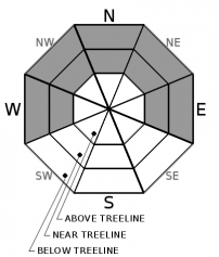
The Dec 11 facets still exist in the snowpack. Data and observations indicate that avalanches on this layer have become unlikely on a regional scale for a variety of reasons. First, this persistent weak layer seems to have gained enough strength to support the snow above it, and second, the snow above it has gotten less slab-like in some areas. This respite from persistent slab avalanche problems may be short-lived. Observations also show that new snow loading could reactivate this layer. With snow forecast for Friday night and Saturday, this persistent slab problem will be back.

While unlikely, it is not impossible that this weak layer may still remain active on some isolated terrain feature due to variability associated with this layer. Keep an eye out for whumpfing sounds, cracking, and/or unstable snowpack test results. Limit exposure to avalanche terrain by having a trip plan, traveling one at a time through avalanche terrain, and regrouping well out of runout zones and avalanche terrain.  

Avalanche Problem 2: Wind Slab
  • Type ?
  • Aspect/Elevation ?
  • Likelihood ?
    Certain
    Very Likely
    Likely
    Possible
    Unlikely
  • Size ?
    Historic
    Very Large
    Large
    Small

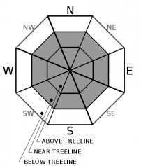
Shifting winds have blown snow back and forth across ridgelines a few times this week. In many areas, the winds have left icy scoured surfaces or even dirt on exposed slopes creating treacherous travel conditions and the potential for long sliding falls. The slabs of wind drifted snow remaining are firm and difficult to break. Since very little snow remains available for transport, new wind slabs should have a hard time forming today and tomorrow. Wind slab avalanches should remain unlikely on a regional scale. Some small wind slabs may not be impossible in complex terrain where a small avalanche could have serious consequences. Once new snow and wind start to impact the area on Friday night into Saturday new wind slabs will start to form and wind slab avalanche will become problematic again.

recent observations

* Small stiff wind slabs 3 to 4'' thick existed on some slopes on Silver Peak (North of Olympic Valley) and near Woods Lake (Carson Pass). Ski kicks did produce some minor cracking in these wind slabs. Firm, icy, scoured slopes and variable wind affected surfaces were reported in near and above treeline terrain on Incline Lake Peak, Silver Peak, Mt. Judah, and Carson Pass. Strong winds have also left firm wind scoured snow surfaces and wind-affected surfaces on many slopes at lower elevations.

* Signs of instability and unstable snowpack test results on the Dec 11 persistent weak layer continued to decrease. Spatial variability continues throughout the forecast area with some areas still reporting unstable snowpack test results. Data also indicates that additional snow load expected on Friday night into Saturday could reactivate this weak layer.

* Some areas of soft cold snow still exist on sheltered northerly facing slopes in near and below treeline terrain. 

Weather and CURRENT CONDITIONS
weather summary

Cold air pooling in the valleys allowed lower elevation temperatures to dip into the teens and low 20's. The upper elevations remained warm with many sensors above 8000 ft. reporting above freezing temperatures overnight. Expect another temperature inversion tomorrow morning. The forecast calls for the winds to shift back to SW today and to increase tomorrow ahead of a winter storm. This storm should bring snow and strong SW winds to the region starting tomorrow evening. Snowfall and wind should continue through Saturday morning with 8 to 12 inches of accumulation possible during that time along the Sierra Crest. Check-in with the Reno NWS for more details.

CONDITIONS ALONG THE SIERRA CREST BETWEEN 8200 FT. AND 9200 FT. IN THE LAST 24 HOURS
6am temperature: 33 to 36 deg. F.
Max. temperature: 39 to 43 deg. F.
Average ridgetop wind direction: E and NE shifting to the SW this morning
Average ridgetop wind speed: 24 to 34 mph
Maximum ridgetop wind gust: 83 mph
New snowfall: 0 inches
Total snow depth: 22 to 28 inches
Two-Day Mountain Weather Forecast Produced in partnership with the Reno NWS
For 7000 ft. to 8000 ft.
Thursday Thursday Night Friday
Weather: Mostly cloudy. Snow levels below 7000 ft. Chance of precipitation is 0%. Mostly cloudy becoming partly cloudy. Snow levels below 7000 ft. Chance of precipitation is 0%. Mostly cloudy. Slight chance of snow in the afternoon. Snow levels below 7000 ft. Chance of precipitation is 20%.
Temperatures: 36 to 41 deg. F. 19 to 25 deg. F. 35 to 40 deg. F.
Mid Slope Winds: Light winds Light winds Light winds becoming southwest around 15 mph with gusts to 40 mph in the afternoon.
Expected snowfall: No accumulation. | SWE = None. No accumulation. | SWE = None. No accumulation. | SWE = Trace amounts.
For 8000 ft. to 9000 ft.
Thursday Thursday Night Friday
Weather: Mostly cloudy. Snow levels below 7000 ft. Chance of precipitation is 0%. Mostly cloudy becoming partly cloudy. Snow levels below 7000 ft. Chance of precipitation is 0%. Mostly cloudy. Slight chance of snow in the afternoon. Snow levels below 7000 ft. Chance of precipitation is 20%.
Temperatures: 33 to 38 deg. F. 18 to 24 deg. F. 31 to 36 deg. F.
Ridge Top Winds: East winds 15-25 mph becoming southwest around 15 mph. Light winds becoming southwest around 15 mph with gusts to 25 mph after midnight. Southwest around 15 mph with gusts to 30 mph increasing to 20 to 30 mph with gusts to 80 mph in the afternoon.
Expected snowfall: No accumulation. | SWE = None. No accumulation. | SWE = None. No accumulation. | SWE = Trace amounts.
Disclaimer

This avalanche forecast is provided through a partnership between the Tahoe National Forest and the Sierra Avalanche Center. This forecast covers the Central Sierra Nevada Mountains between Yuba Pass on the north and Ebbetts Pass on the south. Click here for a map of the forecast area. This forecast applies only to backcountry areas outside established ski area boundaries. This forecast describes general avalanche conditions and local variations always occur. This forecast expires 24 hours after the posted time unless otherwise noted. The information in this forecast is provided by the USDA Forest Service who is solely responsible for its content.

For a recorded version of the avalanche forecast call (530) 587-3558 x258