THIS AVALANCHE FORECAST EXPIRED ON December 30, 2020 @ 6:58 am
Avalanche Forecast published on December 29, 2020 @ 6:58 am
Issued by Steve Reynaud - Tahoe National Forest

Dangerous avalanche conditions continue with persistent slab and wind slab avalanche problems.  Multiple human triggered avalanches have occurred since our last storm 3 days ago.  CONSIDERABLE avalanche danger exists at all elevations.  Advanced terrain management skills are required to avoid these avalanche problems today.

3. Considerable

?

Above Treeline
Dangerous avalanche conditions. Careful snowpack evaluation, cautious route-finding and conservative decision-making essential.

3. Considerable

?

Near Treeline
Dangerous avalanche conditions. Careful snowpack evaluation, cautious route-finding and conservative decision-making essential.

3. Considerable

?

Below Treeline
Dangerous avalanche conditions. Careful snowpack evaluation, cautious route-finding and conservative decision-making essential.
    Dangerous avalanche conditions. Careful snowpack evaluation, cautious route-finding and conservative decision-making essential.
Avalanche Problem 1: Persistent Slab
  • Type ?
  • Aspect/Elevation ?
  • Likelihood ?
    Certain
    Very Likely
    Likely
    Possible
    Unlikely
  • Size ?
    Historic
    Very Large
    Large
    Small

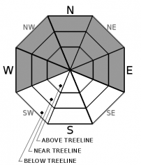
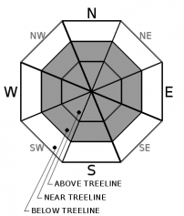
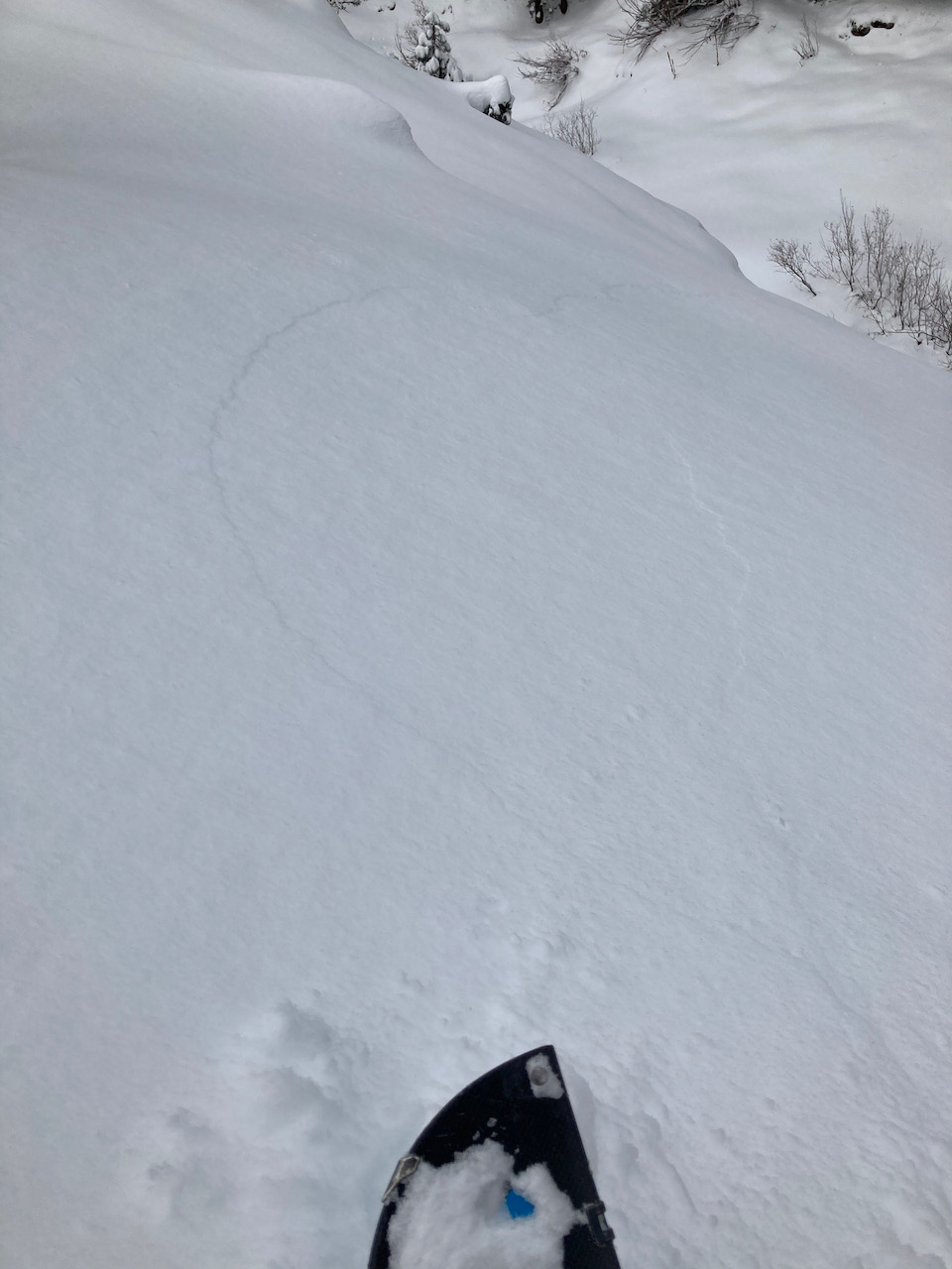
The Dec. 11 persistent weak layer is widespread throughout the forecast region on W-NW-N-NE-E aspects in below and near treeline terrain and more isolated on these aspects in above treeline areas.  Multiple human triggered avalanches have occurred on this weak layer since our last storm 3 days ago.  Several observations from yesterday continue to show whumpfing sounds, cracking, and unstable snowpack test results that point to this weak layer still being reactive and capable of producing large avalanches.  As this weak layer becomes more deeply buried, signs of instability may be harder to find.  Any whumpfing, shooting cracks, or recent avalanche activity would be huge indications of unstable snow, but the first sign could also be you or your group triggering a large slab avalanche.  

Persistent slab avalanche problems are one of the most challenging problems for backcountry users to deal with.  Managing terrain is the easiest way to set yourself up for long term success until this weak layer goes away.  Avoid any avalanche terrain over 30 degrees and any steep connected or overhead terrain.  Remote triggering has occurred on this weak layer and remains possible.  Wide propagation with large avalanches, mid slope avalanches, and avalanches on slopes that already have tracks could also occur.    

Avalanche Problem 2: Wind Slab
  • Type ?
  • Aspect/Elevation ?
  • Likelihood ?
    Certain
    Very Likely
    Likely
    Possible
    Unlikely
  • Size ?
    Historic
    Very Large
    Large
    Small

Strong to gale force NE winds overnight have scoured many exposed slopes and created new wind slabs on SE-S-SW-W-NW aspects.  Previous wind slabs on NW-N-NE-E-SE aspects have been wind scoured in many areas from these winds.  In areas with NE wind protection or in locations where these wind slabs exist over the Dec 11 persistent weak layer, unstable snow with human triggered avalanches remain possible.  Winds will shift to the W tonight and into tomorrow ahead of our next storm.  Wind slab avalanches could be possible on all aspects in near and above treeline areas.

Look for blowing snow, new cornice development, and fresh wind pillows.  Many slopes will have been wind loaded previously during the storm to be wind scoured recently.  Avoid areas under large cornices and steep wind loaded slopes.

recent observations

* Whumpfing, cracking, and unstable snowpack test results were reported from several locations yesterday.  Other mixed results or no unstable results from snowpack tests were reported from other locations. 

*  Slightly buried surface hoar under a dusting to 1-2'' of new snow was reported from the Silver Peak area and Scott Peak (Five Lakes area).


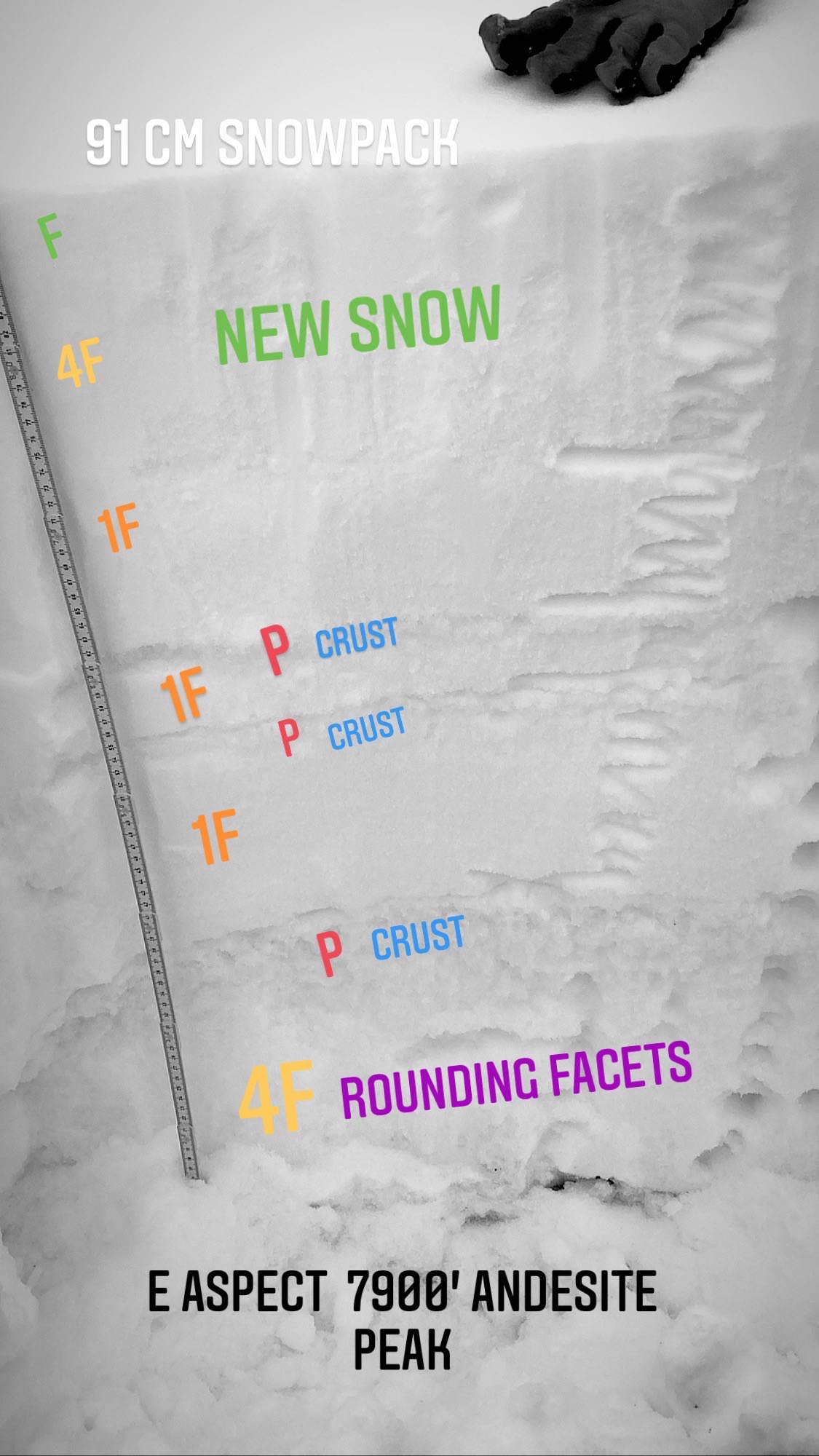
Photo: Whumpfing and shooting cracks on the Dec 11 pwl on Red Lake Peak (Carson Pass).  Andesite Peak(Donner Summit Area) snowpack layers.

Weather and CURRENT CONDITIONS
weather summary

A sunny and cold day is forecasted for today with strong to gale force NE winds in the higher terrain.  Tomorrow has increasing clouds and wind before a cold and fast moving storm approaches our area.  3 to 6'' of snow is possible for Wednesday night into Thursday.  The beginning of 2021 has to potential to start off with a bang and the possibility of a string of wet Sierra storms for the first week of January.

CONDITIONS ALONG THE SIERRA CREST BETWEEN 8200 FT. AND 9200 FT. IN THE LAST 24 HOURS
6am temperature: 12 to 16 deg. F.
Max. temperature: 18 to 29 deg. F.
Average ridgetop wind direction: NE
Average ridgetop wind speed: 30 to 50 mph
Maximum ridgetop wind gust: 73 mph
New snowfall: 0 to trace inches
Total snow depth: 29 to 36 inches
Two-Day Mountain Weather Forecast Produced in partnership with the Reno NWS
For 7000 ft. to 8000 ft.
Tuesday Tuesday Night Wednesday
Weather: Sunny. Snow levels below 7000 feet. Chance of precipitation is 0%. Clear then becoming partly cloudy. Snow levels below 7000 feet. Chance of precipitation is 0%. Mostly cloudy. Snow levels below 7000 feet. Chance of precipitation is 0%.
Temperatures: 30 to 35. deg. F. 14 to 22. deg. F. 34 to 39. deg. F.
Mid Slope Winds: East winds 10 to 15 mph with gusts up to 35 mph in the morning then becoming east 5 to 10 mph. Light winds. Light winds.
Expected snowfall: No accumulation. | SWE = none. No accumulation. | SWE = none. No accumulation. | SWE = none.
For 8000 ft. to 9000 ft.
Tuesday Tuesday Night Wednesday
Weather: Partly cloudy then becoming sunny. Snow levels below 7000 feet. Chance of precipitation is 0%. Clear then becoming partly cloudy. Snow levels below 7000 feet. Chance of precipitation is 0%. Mostly cloudy. Snow levels below 7000 feet. Chance of precipitation is 0%.
Temperatures: 26 to 32. deg. F. 13 to 19. deg. F. 31 to 36. deg. F.
Ridge Top Winds: Northeast 25 to 40 mph decreasing to 20 to 30 mph in the afternoon. Gusts up to 80 mph in the morning decreasing to 60 mph in the afternoon. Northeast 15 to 30 mph with gusts to 55 mph shifting to the west around 15 mph with gusts to 30 mph after midnight. West 15 to 20 mph. Gusts up to 30 mph increasing to 40 mph in the afternoon.
Expected snowfall: No accumulation. | SWE = none. No accumulation. | SWE = none. No accumulation. | SWE = none.
Disclaimer

This avalanche forecast is provided through a partnership between the Tahoe National Forest and the Sierra Avalanche Center. This forecast covers the Central Sierra Nevada Mountains between Yuba Pass on the north and Ebbetts Pass on the south. Click here for a map of the forecast area. This forecast applies only to backcountry areas outside established ski area boundaries. This forecast describes general avalanche conditions and local variations always occur. This forecast expires 24 hours after the posted time unless otherwise noted. The information in this forecast is provided by the USDA Forest Service who is solely responsible for its content.

For a recorded version of the avalanche forecast call (530) 587-3558 x258