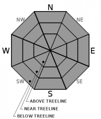
THIS AVALANCHE FORECAST EXPIRED ON December 9, 2020 @ 6:50 am
Avalanche Forecast published on December 8, 2020 @ 6:50 am
Issued by Steve Reynaud - Tahoe National Forest

LOW avalanche danger continues throughout the forecast region.  Caution is advised when traveling in the backcountry due to the early season conditions and thin snowpack.

1. Low

?

Above Treeline
Generally safe avalanche conditions. Watch for unstable snow on isolated terrain features.

1. Low

?

Near Treeline
Generally safe avalanche conditions. Watch for unstable snow on isolated terrain features.

1. Low

?

Below Treeline
Generally safe avalanche conditions. Watch for unstable snow on isolated terrain features.
    Generally safe avalanche conditions. Watch for unstable snow on isolated terrain features.
Avalanche Problem 1: Normal Caution
  • Type ?
  • Aspect/Elevation ?
  • Likelihood ?
    Certain
    Very Likely
    Likely
    Possible
    Unlikely
  • Size ?
    Historic
    Very Large
    Large
    Small

Early season conditions continue throughout the forecast area.  Hazards such as rocks, bushes, stumps, and logs are exposed or barely covered with our current thin snowpack.  Caution is needed to travel slowly and avoid these obstacles.  

Light snow transport was observed yesterday from the strong to gale force NE/E winds.  Most of this blowing snow was along the higher exposed ridges, with any wind slab development expected to be small and isolated due to the lack of available snow for transport.  Gully or couloir features in near and above treeline areas would be the most likely areas for any accumulating wind blown snow.  Winds have decreased from yesterday and will continue to decrease through today.

recent observations

* A mostly usable and supportable snowpack exists above 8600' in the Mt. Rose area, above 7000' along the northern Sierra Crest, and above 8000' along the southern Sierra Crest.

*  Variable snow surface conditions exist from wind scoured surfaces, soft unconsolidated snow, to a variety of crusts.  Northerly aspects in below treeline areas hold the most snow with exposed areas being wind scoured and southerly aspects having limited to no snow coverage.

*  The faceting process continues with clear skies, long nights, and low sun angles.  Near surface facets have developed on NW-N-NE aspects and also observed on W and E aspects in wind protected areas.  These weak loose grains are becoming a greater concern as storms are now in the forecast with the potential for these near surface facets to become a future buried weak layer.  

Weather and CURRENT CONDITIONS
weather summary

High pressure will build back into our area with warming temperatures, sunny skies, and decreasing winds.  The gale force E winds yesterday will continue to decrease through today.  Temperature inversions will build with warmer temperatures at higher elevations and cooler temperatures in the valleys.  A couple storms passing by to the north this week will increase our winds, but will keep us south of the storm track.  A chance of snow with some small storms becomes possible this weekend.  This could be the start of a more progressive weather pattern that opens up more storms for our area next week. 

CONDITIONS ALONG THE SIERRA CREST BETWEEN 8200 FT. AND 9200 FT. IN THE LAST 24 HOURS
6am temperature: 33 to 37 deg. F.
Max. temperature: 35 to 42 deg. F.
Average ridgetop wind direction: NE/E
Average ridgetop wind speed: 30 to 40 mph
Maximum ridgetop wind gust: 110 mph
New snowfall: 0 inches
Total snow depth: 14 to 17 inches
Two-Day Mountain Weather Forecast Produced in partnership with the Reno NWS
For 7000 ft. to 8000 ft.
Tuesday Tuesday Night Wednesday
Weather: Sunny. Snow levels below 7000 feet increasing to 7000 feet in the afternoon. Chance of precipitation is 0%. Clear. Snow levels below 7000 feet. Chance of precipitation is 0%. Sunny then becoming partly cloudy. Snow levels below 7000 feet. Chance of precipitation is 0%.
Temperatures: 48 to 53. deg. F. 25 to 33. deg. F. 45 to 50. deg. F.
Mid Slope Winds: Light winds. Light winds. Light winds.
Expected snowfall: No accumulation. | SWE = none. No accumulation. | SWE = none. No accumulation. | SWE = none.
For 8000 ft. to 9000 ft.
Tuesday Tuesday Night Wednesday
Weather: Sunny. Snow levels below 7000 feet increasing to 7000 feet in the afternoon. Chance of precipitation is 0%. Clear. Snow levels 7000 feet. Chance of precipitation is 0%. Sunny then becoming partly cloudy. Snow levels below 7000 feet. Chance of precipitation is 0%.
Temperatures: 46 to 51. deg. F. 25 to 31. deg. F. 41 to 46. deg. F.
Ridge Top Winds: Southeast around 15 mph with gusts to 35 mph. Light winds. West around 15 mph in the morning becoming light.
Expected snowfall: No accumulation. | SWE = none. No accumulation. | SWE = none. No accumulation. | SWE = none.
Disclaimer

This avalanche forecast is provided through a partnership between the Tahoe National Forest and the Sierra Avalanche Center. This forecast covers the Central Sierra Nevada Mountains between Yuba Pass on the north and Ebbetts Pass on the south. Click here for a map of the forecast area. This forecast applies only to backcountry areas outside established ski area boundaries. This forecast describes general avalanche conditions and local variations always occur. This forecast expires 24 hours after the posted time unless otherwise noted. The information in this forecast is provided by the USDA Forest Service who is solely responsible for its content.

For a recorded version of the avalanche forecast call (530) 587-3558 x258