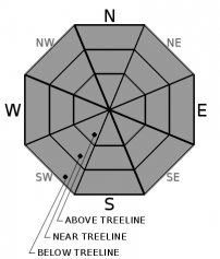
THIS AVALANCHE FORECAST EXPIRED ON February 13, 2020 @ 6:52 am
Avalanche Forecast published on February 12, 2020 @ 6:52 am
Issued by Steve Reynaud - Tahoe National Forest

Warming temperatures with decreasing winds could allow for small loose wet instabilities to form during the midday hours.  Areas of firm snow continue with potential falling hazards.  LOW avalanche danger exists with normal caution advised.

1. Low

?

Above Treeline
Generally safe avalanche conditions. Watch for unstable snow on isolated terrain features.

1. Low

?

Near Treeline
Generally safe avalanche conditions. Watch for unstable snow on isolated terrain features.

1. Low

?

Below Treeline
Generally safe avalanche conditions. Watch for unstable snow on isolated terrain features.
    Generally safe avalanche conditions. Watch for unstable snow on isolated terrain features.
Avalanche Problem 1: Normal Caution
  • Type ?
  • Aspect/Elevation ?
  • Likelihood ?
    Certain
    Very Likely
    Likely
    Possible
    Unlikely
  • Size ?
    Historic
    Very Large
    Large
    Small

Warmer overnight temperatures with decreasing winds should allow the snow surface to soften on more aspects and elevations today.  The snowpack on southerly aspects is coming off of multiple days of below freezing temperatures which has left a strong and well consolidated snowpack.  Soft corn snow developed on wind protected lower to mid elevations yesterday with favorable conditions today to see more widespread softening.  Small loose wet instabilities could develop on E-SE-S-SW-W aspects at all elevations as warming occurs throughout the day.  These instabilities are expected to be small in size and in the form of roller balls and pinwheels.

Large areas of firm snow continue to exist throughout the backcountry, especially in heavily wind scoured locations.  Exposed terrain on NW-N-NE aspects is not expected to soften today and will remain rock hard in many locations.  Sliding falls remain a concern.

Make a travel plan with your group that is appropriate for the current conditions.  Utilize terrain options to avoid any areas of concern.                           

recent observations

Soft corn snow developed on wind protected southerly aspects on Silver Peak (Pole Creek area) by early afternoon.  Firm snow conditions were present in the morning and softened on SE/S aspects below 8000' with other areas remaining firm.  In wind protected northerly areas, decomposing surface crusts with near surface facets provided consistent travel conditions.

Observations from Blue Lakes (Carson Pass area), showed a very firm snowpack in the morning that softened slightly into the afternoon.  Some areas of soft unconsolidated snow existed in wind protected gullies and drainages.  

Weather and CURRENT CONDITIONS
weather summary

Dry northerly flow will continue into Thursday with decreasing winds and slightly warmer temperatures.  Inversions developed overnight with warmer air at upper elevations and cool air settling into the lower valleys.  Temperatures along the Sierra Crest above 8000' were at 26 to 37 degrees for the overnight low, with areas below 7000' in the mid to low 20's.  Some high clouds could develop throughout the area today.  There remains a chance of light precipitation with increasing winds on late Saturday into Sunday.   

CONDITIONS ALONG THE SIERRA CREST BETWEEN 8200 FT. AND 9200 FT. IN THE LAST 24 HOURS
6am temperature: 26 to 37 deg. F.
Max. temperature: 34 to 42 deg. F.
Average ridgetop wind direction: NE shifting to NW
Average ridgetop wind speed: 20 to 40 decreasing to 10 to 15 mph
Maximum ridgetop wind gust: 102 mph
New snowfall: 0 inches
Total snow depth: 41 to 51 inches
Two-Day Mountain Weather Forecast Produced in partnership with the Reno NWS
For 7000 ft. to 8000 ft.
Wednesday Wednesday Night Thursday
Weather: Mostly sunny. Snow levels below 7000 feet. Chance of precipitation is 0%. Clear. Snow levels below 7000 feet. Chance of precipitation is 0%. Sunny. Snow levels below 7000 feet. Chance of precipitation is 0%.
Temperatures: 41 to 47. deg. F. 19 to 24. deg. F. 43 to 48. deg. F.
Mid Slope Winds: Light winds. Light winds. Light winds becoming southwest around 10 mph in the afternoon.
Expected snowfall: No accumulation. | SWE = none. No accumulation. | SWE = none. No accumulation. | SWE = none.
For 8000 ft. to 9000 ft.
Wednesday Wednesday Night Thursday
Weather: Mostly sunny. Snow levels below 7000 feet. Chance of precipitation is 0%. Clear. Snow levels below 7000 feet. Chance of precipitation is 0%. Sunny. Snow levels below 7000 feet. Chance of precipitation is 0%.
Temperatures: 35 to 40. deg. F. 21 to 26. deg. F. 38 to 43. deg. F.
Ridge Top Winds: North around 15 mph with gusts to 30 mph. East around 15 mph in the evening becoming light. Light winds becoming southwest around 15 mph with gusts to 30 mph in the afternoon.
Expected snowfall: No accumulation. | SWE = none. No accumulation. | SWE = none. No accumulation. | SWE = none.
Disclaimer

This avalanche forecast is provided through a partnership between the Tahoe National Forest and the Sierra Avalanche Center. This forecast covers the Central Sierra Nevada Mountains between Yuba Pass on the north and Ebbetts Pass on the south. Click here for a map of the forecast area. This forecast applies only to backcountry areas outside established ski area boundaries. This forecast describes general avalanche conditions and local variations always occur. This forecast expires 24 hours after the posted time unless otherwise noted. The information in this forecast is provided by the USDA Forest Service who is solely responsible for its content.

For a recorded version of the avalanche forecast call (530) 587-3558 x258