THIS AVALANCHE FORECAST EXPIRED ON February 17, 2020 @ 6:59 am
Avalanche Forecast published on February 16, 2020 @ 6:59 am
Issued by Andy Anderson - Tahoe National Forest - Sierra Avalanche Center

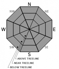
Some soft wet snow may form on wind-protected slopes today, but significant loose wet instabilities are unlikely due to increased cloud cover and wind. Widespread firm snow surfaces mean long sliding falls or collisions with exposed obstacles pose a greater threat to backcountry travelers than avalanche activity today. The avalanche danger will remain LOW

1. Low

?

Above Treeline
Generally safe avalanche conditions. Watch for unstable snow on isolated terrain features.

1. Low

?

Near Treeline
Generally safe avalanche conditions. Watch for unstable snow on isolated terrain features.

1. Low

?

Below Treeline
Generally safe avalanche conditions. Watch for unstable snow on isolated terrain features.
    Generally safe avalanche conditions. Watch for unstable snow on isolated terrain features.
Avalanche Problem 1: Normal Caution
  • Type ?
  • Aspect/Elevation ?
  • Likelihood ?
    Certain
    Very Likely
    Likely
    Possible
    Unlikely
  • Size ?
    Historic
    Very Large
    Large
    Small

A weaker refreeze may have occurred last night due to warmer overnight temperatures and cloud cover. Despite this weaker refreeze, increased cloud cover and wind today should limit the amount of wet surface snow that forms. In some places, especially lower elevation wind-protected E-SE-S-SW-W aspects, enough warming may occur for the snow surface to soften by midday. However, many of the more exposed and upper elevation slopes may remain mostly firm today. Sizable loose wet instabilities are unlikely. 

Even though the avalanche danger is low, other hazards like long sliding falls on firm snow surfaces exist in the backcountry. Talk with your group and make a plan that addresses the variable and challenging snow conditions by using appropriate terrain selection and timing. If you encounter conditions don't match your group's equipment and abilities, be flexible and move to a different slope or even a different activity. 

recent observations

* Spring-like melt-freeze conditions exist on sun-exposed E-SE-S-SW-W aspects.

* NW-N-NE aspects hold variable conditions with mostly firm surfaces on near and above treeline slopes and breakable crust with isolated pockets of softer snow on wind-protected below treeline slopes.

* No reports of new loose wet avalanches have been received this week.

Weather and CURRENT CONDITIONS
weather summary

Yesterday's cloud cover continued to increase during the night. An approaching cold front should keep skies mostly cloudy even though temperatures should stay slightly above average today. The weak cold front will also bring increased SW winds, especially along the ridgetops. As the front passes through the area tonight temperatures should decrease and the winds should shift to the NE for tomorrow. Expect tomorrow's highs to be a few degrees cooler than today. 

CONDITIONS ALONG THE SIERRA CREST BETWEEN 8200 FT. AND 9200 FT. IN THE LAST 24 HOURS
6am temperature: 27 to 35 deg. F.
Max. temperature: 34 to 46 deg. F.
Average ridgetop wind direction: SW
Average ridgetop wind speed: 25 to 35 mph
Maximum ridgetop wind gust: 65 mph
New snowfall: 0 inches
Total snow depth: 40 to 49 inches
Two-Day Mountain Weather Forecast Produced in partnership with the Reno NWS
For 7000 ft. to 8000 ft.
Sunday Sunday Night Monday
Weather: Mostly cloudy. Chance of precipitation is 5%. Mostly cloudy. Chance of precipitation is 0%. Partly cloudy becoming sunny. Chance of precipitation is 0%
Temperatures: 42 to 48 deg. F. 22 to 27 deg. F. 40 to 46 deg. F.
Mid Slope Winds: Southwest 15 to 25 mph with gusts to 45 mph. West 15 to 20 mph with gusts to 40 mph in the evening becoming light. Light winds becoming northeast around 15 mph in the afternoon. Gusts up to 35 mph.
Expected snowfall: No accumulation | SWE = None No accumulation | SWE = None No accumulation | SWE = None
For 8000 ft. to 9000 ft.
Sunday Sunday Night Monday
Weather: Mostly cloudy. Chance of precipitation is 5%. Mostly cloudy. Chance of precipitation is 0%. Partly cloudy becoming sunny. Chance of precipitation is 0%
Temperatures: 37 to 43 deg. F. 20 to 25 deg. F. 35 to 41 deg. F.
Ridge Top Winds: West 35 to 45 mph with gusts to 90 mph. West 15 to 30 mph. Gusts up to 70 mph decreasing to 40 mph after midnight. Northeast 15 to 25 mph with gusts to 40 mph.
Expected snowfall: No accumulation | SWE = None No accumulation | SWE = None No accumulation | SWE = None
Disclaimer

This avalanche forecast is provided through a partnership between the Tahoe National Forest and the Sierra Avalanche Center. This forecast covers the Central Sierra Nevada Mountains between Yuba Pass on the north and Ebbetts Pass on the south. Click here for a map of the forecast area. This forecast applies only to backcountry areas outside established ski area boundaries. This forecast describes general avalanche conditions and local variations always occur. This forecast expires 24 hours after the posted time unless otherwise noted. The information in this forecast is provided by the USDA Forest Service who is solely responsible for its content.

For a recorded version of the avalanche forecast call (530) 587-3558 x258