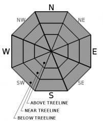
THIS AVALANCHE FORECAST EXPIRED ON February 18, 2020 @ 6:59 am
Avalanche Forecast published on February 17, 2020 @ 6:59 am
Issued by Andy Anderson - Tahoe National Forest - Sierra Avalanche Center

Refrozen surfaces may take longer to soften today because of cooler temperatures and NE winds. Significant loose wet instabilities should remain unlikely. Careful timing and terrain selection can help find softer snow and avoid firm snow surfaces where long sliding falls could occur. The avalanche danger will remain LOW

1. Low

?

Above Treeline
Generally safe avalanche conditions. Watch for unstable snow on isolated terrain features.

1. Low

?

Near Treeline
Generally safe avalanche conditions. Watch for unstable snow on isolated terrain features.

1. Low

?

Below Treeline
Generally safe avalanche conditions. Watch for unstable snow on isolated terrain features.
    Generally safe avalanche conditions. Watch for unstable snow on isolated terrain features.
Avalanche Problem 1: Normal Caution
  • Type ?
  • Aspect/Elevation ?
  • Likelihood ?
    Certain
    Very Likely
    Likely
    Possible
    Unlikely
  • Size ?
    Historic
    Very Large
    Large
    Small

Lows in the 20's and less cloud cover during the night should have allowed for a solid overnight refreeze. Today, widespread sunshine will work to melt the refreeze while slightly cooler temperatures and NE winds will work to keep the snow surfaces cool. On lower elevation, wind-protected E-SE-S-SW-W aspects, the warming side should have the advantage and the snow surface could soften by midday. On more wind-exposed upper elevation slopes, the balance may remain tipped toward cooling and surfaces could remain mostly firm today. Sizable loose wet instabilities remain unlikely. 

Firm and variable conditions with many exposed obstacles present hazards like long sliding falls and collisions with immovable objects. Terrain selection and careful timing can lead your group to softer more enjoyable snow. If conditions don't match your group's skills and equipment, wait for the snow to soften, move to a different slope, or even retreat to a different activity. 

recent observations

* Spring-like melt-freeze conditions exist on sun-exposed E-SE-S-SW-W aspects.

* NW-N-NE aspects hold variable conditions with mostly firm surfaces on near and above treeline slopes and breakable crust with isolated pockets of softer snow on wind-protected below treeline slopes. Yesterday observers also reported wet sticky snow on some lower elevation northerly aspects.

* No reports of new loose wet avalanches have been received this week.

Weather and CURRENT CONDITIONS
weather summary

After a warm day with a mix of sun and some clouds yesterday, the weather turned cooler last night and temperatures fell into the 20's above 7000 ft. Cloud cover started to clear during the night and the wind shifted to the NE and decreased. Expect cooler temperatures, mostly clear skies, and continued NE wind today. Some cloud cover may return tomorrow as another weak cold front moves past the region.

CONDITIONS ALONG THE SIERRA CREST BETWEEN 8200 FT. AND 9200 FT. IN THE LAST 24 HOURS
6am temperature: 22 to 28 deg. F.
Max. temperature: 33 to 44 deg. F.
Average ridgetop wind direction: SW shifting to NE after 6 pm yesterday
Average ridgetop wind speed: SW: 30-40 mph | NE: 15-20 mph
Maximum ridgetop wind gust: SW: 75 mph | NE: 38 mph
New snowfall: 0 inches
Total snow depth: 40 to 49 inches
Two-Day Mountain Weather Forecast Produced in partnership with the Reno NWS
For 7000 ft. to 8000 ft.
Monday Monday Night Tuesday
Weather: Partly cloudy then becoming sunny. Chance of precipitation is 0%. Clear. Chance of precipitation is 0%. Sunny then becoming partly cloudy. Chance of precipitation is 0%.
Temperatures: 40 to 46 deg. F. 17 to 22 deg. F. 39 to 45 deg. F.
Mid Slope Winds: North around 10 mph. Northeast around 10 mph. Light winds becoming southwest around 15 mph
Expected snowfall: No accumulation. | SWE = none. No accumulation. | SWE = none. No accumulation. | SWE = none.
For 8000 ft. to 9000 ft.
Monday Monday Night Tuesday
Weather: Partly cloudy then becoming sunny. Chance of precipitation is 0%. Clear. Chance of precipitation is 0%. Sunny then becoming partly cloudy. Chance of precipitation is 0%.
Temperatures: 35 to 41 deg. F. 15 to 20 deg. F. 33 to 41 deg. F.
Ridge Top Winds: Northeast around 15 mph with gusts to 35 mph. Northeast 15 to 20 mph with gusts to 35 mph. Southwest 15 to 20 mph with gusts to 35 mph.
Expected snowfall: No accumulation. | SWE = none. No accumulation. | SWE = none. No accumulation. | SWE = none.
Disclaimer

This avalanche forecast is provided through a partnership between the Tahoe National Forest and the Sierra Avalanche Center. This forecast covers the Central Sierra Nevada Mountains between Yuba Pass on the north and Ebbetts Pass on the south. Click here for a map of the forecast area. This forecast applies only to backcountry areas outside established ski area boundaries. This forecast describes general avalanche conditions and local variations always occur. This forecast expires 24 hours after the posted time unless otherwise noted. The information in this forecast is provided by the USDA Forest Service who is solely responsible for its content.

For a recorded version of the avalanche forecast call (530) 587-3558 x258