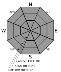
THIS AVALANCHE FORECAST EXPIRED ON February 19, 2020 @ 6:52 am
Avalanche Forecast published on February 18, 2020 @ 6:52 am
Issued by Steve Reynaud - Tahoe National Forest

Firm snow conditions are expected in many areas with some locations softening throughout the day.  Sliding falls on firm snow remain a hazard.  LOW avalanche danger continues with normal caution advised.

1. Low

?

Above Treeline
Generally safe avalanche conditions. Watch for unstable snow on isolated terrain features.

1. Low

?

Near Treeline
Generally safe avalanche conditions. Watch for unstable snow on isolated terrain features.

1. Low

?

Below Treeline
Generally safe avalanche conditions. Watch for unstable snow on isolated terrain features.
    Generally safe avalanche conditions. Watch for unstable snow on isolated terrain features.
Avalanche Problem 1: Normal Caution
  • Type ?
  • Aspect/Elevation ?
  • Likelihood ?
    Certain
    Very Likely
    Likely
    Possible
    Unlikely
  • Size ?
    Historic
    Very Large
    Large
    Small

Below freezing temperatures with mostly clear overnight skies should have allowed for another solid refreeze of the snow surface.  Cool temperatures with light to moderate SW winds today should limit snow surface melt in many areas.  Firm and variable snow conditions will be present on many aspects and elevations.  Wet snow instabilities are expected to be minor and not pose a concern for backcountry users today.  The best chances to find soft snow will be at mid to lower elevations on southerly aspects.  Wind protected areas around rocks and gully features may help to encourage additional snow surface softening.

Sliding falls in steep and exposed terrain on firm snow continue to be a major hazard.  Make sure your group comes up with a tour plan and chooses appropriate terrain for the current conditions. 

recent observations

A strong refreeze of the snow surface was reported from Relay Peak (Mt. Rose area) yesterday.  Challenging firm snow conditions were reported with ski crampons used to gain access to upper ridgetops.  Some corn snow was found in below treeline wind protected terrain on south aspects by midday. 

Observations from Mt. Judah (Donner Summit area) saw mostly firm and variable snow surface conditions throughout the day.  By 2pm, some soft snow existed below the ridgeline in more wind protected terrain.

No loose wet avalanches have been reported for the past week.

Weather and CURRENT CONDITIONS
weather summary

Dry and cool conditions will prevail for most of this week.  A couple weak systems will brush by our area towards the weekend.  Both systems look to have limited to no precipitation for us, with the potential for below average temperatures with increasing winds.  Skies were mostly clear overnight with some thin cloud cover at some locations with near to below freezing temperatures.  Yesterday’s NE winds shifted to the SW last night and will increase to moderate wind speeds today.   

CONDITIONS ALONG THE SIERRA CREST BETWEEN 8200 FT. AND 9200 FT. IN THE LAST 24 HOURS
6am temperature: 25 to 34 deg. F.
Max. temperature: 32 to 45 deg. F.
Average ridgetop wind direction: NE shifting to SW
Average ridgetop wind speed: 15 to 35 mph
Maximum ridgetop wind gust: 58 mph
New snowfall: 0 inches
Total snow depth: 39 to 49 inches
Two-Day Mountain Weather Forecast Produced in partnership with the Reno NWS
For 7000 ft. to 8000 ft.
Tuesday Tuesday Night Wednesday
Weather: Partly cloudy then becoming sunny. Snow levels below 7000 feet. Chance of precipitation is 0%. Partly cloudy. Snow levels below 7000 feet. Chance of precipitation is 0%. Partly cloudy then becoming sunny. Snow levels below 7000 feet. Chance of precipitation is 0%.
Temperatures: 38 to 44. deg. F. 17 to 22. deg. F. 36 to 42. deg. F.
Mid Slope Winds: Light winds becoming southwest around 15 mph in the afternoon. Gusts up to 30 mph. Southwest around 15 mph with gusts to 25 mph in the evening becoming light. Light winds.
Expected snowfall: No accumulation. | SWE = none. No accumulation. | SWE = none. No accumulation. | SWE = none.
For 8000 ft. to 9000 ft.
Tuesday Tuesday Night Wednesday
Weather: Partly cloudy then becoming sunny. Snow levels below 7000 feet. Chance of precipitation is 0%. Partly cloudy. Snow levels below 7000 feet. Chance of precipitation is 0%. Partly cloudy then becoming sunny. Snow levels below 7000 feet. Chance of precipitation is 0%.
Temperatures: 33 to 39. deg. F. 14 to 19. deg. F. 30 to 36. deg. F.
Ridge Top Winds: Southwest 15 to 20 mph with gusts to 30 mph. Southwest around 15 mph with gusts to 30 mph. East around 15 mph. Gusts up to 25 mph in the morning.
Expected snowfall: No accumulation. | SWE = none. No accumulation. | SWE = none. No accumulation. | SWE = none.
Disclaimer

This avalanche forecast is provided through a partnership between the Tahoe National Forest and the Sierra Avalanche Center. This forecast covers the Central Sierra Nevada Mountains between Yuba Pass on the north and Ebbetts Pass on the south. Click here for a map of the forecast area. This forecast applies only to backcountry areas outside established ski area boundaries. This forecast describes general avalanche conditions and local variations always occur. This forecast expires 24 hours after the posted time unless otherwise noted. The information in this forecast is provided by the USDA Forest Service who is solely responsible for its content.

For a recorded version of the avalanche forecast call (530) 587-3558 x258