THIS AVALANCHE FORECAST EXPIRED ON February 21, 2020 @ 6:56 am
Avalanche Forecast published on February 20, 2020 @ 6:56 am
Issued by Brandon Schwartz - Tahoe National Forest

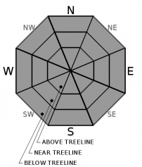
Snow surface melt could allow for small areas of loose wet instabilities to form during the afternoon hours on slopes with direct sun exposure, wind protection, and minimal cloud cover. Areas of very firm snow surfaces exist with a potential sliding fall hazard. LOW avalanche danger exists with normal caution advised.

1. Low

?

Above Treeline
Generally safe avalanche conditions. Watch for unstable snow on isolated terrain features.

1. Low

?

Near Treeline
Generally safe avalanche conditions. Watch for unstable snow on isolated terrain features.

1. Low

?

Below Treeline
Generally safe avalanche conditions. Watch for unstable snow on isolated terrain features.
    Generally safe avalanche conditions. Watch for unstable snow on isolated terrain features.
Avalanche Problem 1: Normal Caution
  • Type ?
  • Aspect/Elevation ?
  • Likelihood ?
    Certain
    Very Likely
    Likely
    Possible
    Unlikely
  • Size ?
    Historic
    Very Large
    Large
    Small

Air temperatures well below freezing last night are expected to have created a strong snow surface refreeze. Daytime warming will lead to snow surface melt today during the late morning and afternoon hours. How much melt occurs will vary slope by slope and be dependent on cloud cover and wind exposure. In areas with direct sun exposure, wind protection, and minimal cloud cover, minor loose wet instabilities may form this afternoon.

There are lots of areas with firm snow surfaces out there and sliding falls leading to impacts with rocks or trees remain a concern. Plan accordingly in terms of terrain, route selection, group ability, and equipment.

recent observations

* Diurnal melt-freeze conditions continue on sun exposed E-SE-S-SW-W aspects.

* Highly variable snow surface conditions exist on NW-N-NE aspects. Mostly firm conditions exist near and above treeline. A mix of breakable to supportable crust with pockets of softer faceted surface snow exist in below treeline areas with NE wind protection.

Weather and CURRENT CONDITIONS
weather summary

Air temperatures will warm above freezing again today for nearly all locations within the forecast area. Some cloud cover moved into the region last night and will remain overhead at times today and tomorrow. Light to moderate speed ridgetop wind is expected today from the S to SE, decreasing in speed for tomorrow. A weather system is forecast to pass by to the south of the forecast area on Saturday. This system may bring some very light precipitation to the far southern end of the forecast area.

CONDITIONS ALONG THE SIERRA CREST BETWEEN 8200 FT. AND 9200 FT. IN THE LAST 24 HOURS
6am temperature: 23 to 28 deg. F.
Max. temperature: 35 to 41 deg. F.
Average ridgetop wind direction: NE
Average ridgetop wind speed: 12 mph
Maximum ridgetop wind gust: 30 mph
New snowfall: 0 inches
Total snow depth: 40 to 49 inches
Two-Day Mountain Weather Forecast Produced in partnership with the Reno NWS
For 7000 ft. to 8000 ft.
Thursday Thursday Night Friday
Weather: Mostly cloudy then becoming partly cloudy. Chance of precipitation is 0%. Partly cloudy. Chance of precipitation is 0%. Partly cloudy. Snow level 8000 feet. Chance of precipitation is 10%.
Temperatures: 41 to 47. deg. F. 23 to 28. deg. F. 41 to 47. deg. F.
Mid Slope Winds: Light winds becoming southeast around 15 mph in the afternoon. Gusts up to 30 mph. Light winds. Gusts up to 25 mph in the evening. Light winds.
Expected snowfall: No accumulation. | SWE = none. No accumulation. | SWE = none. No accumulation. | SWE = none.
For 8000 ft. to 9000 ft.
Thursday Thursday Night Friday
Weather: Mostly cloudy then becoming partly cloudy. Chance of precipitation is 0%. Partly cloudy. Chance of precipitation is 0%. Partly cloudy. Snow level 8000 feet. Chance of precipitation is 10%.
Temperatures: 35 to 41. deg. F. 21 to 26. deg. F. 36 to 42. deg. F.
Ridge Top Winds: South 15 to 20 mph. Gusts up to 40 mph decreasing to 30 mph in the afternoon. Southeast around 15 mph with gusts to 25 mph. Light winds becoming east around 15 mph with gusts to 25 mph in the afternoon.
Expected snowfall: No accumulation. | SWE = none. No accumulation. | SWE = none. No accumulation. | SWE = none.
Disclaimer

This avalanche forecast is provided through a partnership between the Tahoe National Forest and the Sierra Avalanche Center. This forecast covers the Central Sierra Nevada Mountains between Yuba Pass on the north and Ebbetts Pass on the south. Click here for a map of the forecast area. This forecast applies only to backcountry areas outside established ski area boundaries. This forecast describes general avalanche conditions and local variations always occur. This forecast expires 24 hours after the posted time unless otherwise noted. The information in this forecast is provided by the USDA Forest Service who is solely responsible for its content.

For a recorded version of the avalanche forecast call (530) 587-3558 x258