THIS AVALANCHE FORECAST EXPIRED ON February 22, 2020 @ 6:57 am
Avalanche Forecast published on February 21, 2020 @ 6:57 am
Issued by Brandon Schwartz - Tahoe National Forest

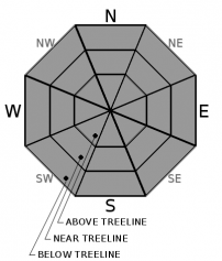
Snow surface melt leading to small areas of loose wet instabilities during the afternoon hours is unlikely but not impossible on slopes with direct sun exposure, wind protection, and minimal cloud cover. Areas of very firm snow surfaces exist with a potential sliding fall hazard. LOW avalanche danger exists with normal caution advised.

1. Low

?

Above Treeline
Generally safe avalanche conditions. Watch for unstable snow on isolated terrain features.

1. Low

?

Near Treeline
Generally safe avalanche conditions. Watch for unstable snow on isolated terrain features.

1. Low

?

Below Treeline
Generally safe avalanche conditions. Watch for unstable snow on isolated terrain features.
    Generally safe avalanche conditions. Watch for unstable snow on isolated terrain features.
Avalanche Problem 1: Normal Caution
  • Type ?
  • Aspect/Elevation ?
  • Likelihood ?
    Certain
    Very Likely
    Likely
    Possible
    Unlikely
  • Size ?
    Historic
    Very Large
    Large
    Small

A decent snow surface refreeze is expected to have occurred last night despite some cloud cover and a few weather stations in the 7,800' to 8,200' elevation range reporting above freezing air temperatures due to weak air temperature inversion. Daytime warming will lead to snow surface melt today during the late morning and afternoon hours, mainly on mid to lower elevation slopes. How much melt occurs today will vary slope by slope and be dependent on cloud cover and wind exposure. Minor loose wet instabilities are unlikely but not impossible this afternoon in areas of direct sun exposure, wind protection, and minimal cloud cover. Some slopes, especially at the upper elevations may stay frozen and firm all day.

There are lots of areas with firm snow surfaces out there and sliding falls leading to impacts with rocks or trees remain a concern. Plan accordingly in terms of terrain, route selection, group ability, and equipment.

recent observations

* Diurnal melt-freeze conditions continue on sun exposed E-SE-S-SW-W aspects.

* Highly variable snow surface conditions exist on NW-N-NE aspects. Mostly firm conditions exist near and above treeline. A mix of breakable to supportable crust with pockets of softer faceted surface snow exist in below treeline areas with NE wind protection.

Weather and CURRENT CONDITIONS
weather summary

A bit more mid and high level cloud cover moved into the forecast area last night. Afternoon cumulus buildups may occur today with showers unlikely to reach the ground (virga) due to a very dry lower atmosphere. Cloud cover will stick around through tomorrow as a weather system passes to the south of the forecast area. There is a slight chance that light precipitation will provide a dusting of new snow over the far southern end of the forecast area on Saturday. Light to moderate speed ridgetop winds out of the S to E are forecast to continue through tonight and become light tomorrow.

CONDITIONS ALONG THE SIERRA CREST BETWEEN 8200 FT. AND 9200 FT. IN THE LAST 24 HOURS
6am temperature: 26 to 33 deg. F.
Max. temperature: 35 to 45 deg. F.
Average ridgetop wind direction: S with a brief period of E
Average ridgetop wind speed: 16 mph
Maximum ridgetop wind gust: 38 mph
New snowfall: 0 inches
Total snow depth: 40 to 49 inches
Two-Day Mountain Weather Forecast Produced in partnership with the Reno NWS
For 7000 ft. to 8000 ft.
Friday Friday Night Saturday
Weather: Partly cloudy. Snow levels below 7000 feet. Chance of precipitation is 5%. Mostly cloudy. Snow levels below 7000 feet. Chance of precipitation is 5%. Mostly cloudy then becoming partly cloudy. Slight chance of snow. Snow levels below 7000 feet. Chance of precipitation is 15%.
Temperatures: 41 to 47. deg. F. 24 to 29. deg. F. 42 to 48. deg. F.
Mid Slope Winds: Light winds. Light winds. Light winds.
Expected snowfall: No accumulation. | SWE = none. No accumulation. | SWE = none. 10% probability up to 1 inch. 90% probability no accumulation. | SWE = trace amounts.
For 8000 ft. to 9000 ft.
Friday Friday Night Saturday
Weather: Partly cloudy. Snow levels below 7000 feet. Chance of precipitation is 5%. Mostly cloudy. Snow levels below 7000 feet. Chance of precipitation is 10%. Mostly cloudy then becoming partly cloudy. Slight chance of snow. Snow levels below 7000 feet. Chance of precipitation is 15%.
Temperatures: 36 to 42. deg. F. 22 to 27. deg. F. 36 to 42. deg. F.
Ridge Top Winds: Light winds becoming south around 15 mph with gusts to 25 mph in the afternoon. East around 15 mph with gusts to 25 mph. East around 15 mph in the morning becoming light.
Expected snowfall: No accumulation. | SWE = none. No accumulation. | SWE = none. 10% probability up to 1 inch. 90% probability no accumulation. | SWE = trace amounts.
Disclaimer

This avalanche forecast is provided through a partnership between the Tahoe National Forest and the Sierra Avalanche Center. This forecast covers the Central Sierra Nevada Mountains between Yuba Pass on the north and Ebbetts Pass on the south. Click here for a map of the forecast area. This forecast applies only to backcountry areas outside established ski area boundaries. This forecast describes general avalanche conditions and local variations always occur. This forecast expires 24 hours after the posted time unless otherwise noted. The information in this forecast is provided by the USDA Forest Service who is solely responsible for its content.

For a recorded version of the avalanche forecast call (530) 587-3558 x258