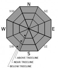
THIS AVALANCHE FORECAST EXPIRED ON February 24, 2020 @ 6:59 am
Avalanche Forecast published on February 23, 2020 @ 6:59 am
Issued by Andy Anderson - Tahoe National Forest - Sierra Avalanche Center

Enough warming should occur for many sun-exposed slopes to soften today, but it should not get warm enough for significant wet loose instabilities to form. Some slopes may remain firm and challenging to recreate on. LOW avalanche danger exists with normal caution advised.

1. Low

?

Above Treeline
Generally safe avalanche conditions. Watch for unstable snow on isolated terrain features.

1. Low

?

Near Treeline
Generally safe avalanche conditions. Watch for unstable snow on isolated terrain features.

1. Low

?

Below Treeline
Generally safe avalanche conditions. Watch for unstable snow on isolated terrain features.
    Generally safe avalanche conditions. Watch for unstable snow on isolated terrain features.
Avalanche Problem 1: Normal Caution
  • Type ?
  • Aspect/Elevation ?
  • Likelihood ?
    Certain
    Very Likely
    Likely
    Possible
    Unlikely
  • Size ?
    Historic
    Very Large
    Large
    Small

Clear skies and cool overnight temperatures should have allowed the snowpack to refreeze. As the day warms up, the firm refrozen surfaces should soften starting with the sun-exposed E-SE aspects and progressing to the S-SW-W aspects throughout the day. Wind-sheltered mid to lower elevations slopes should experience the most warming while more exposed upper elevation slopes will take longer to soften. In some places, these upper elevation areas may remain firm for most of the day.  A strong overnight refreeze, moderately warm daytime highs, and some light winds today should help limit the amount of wet snow that forms. Significant loose wet avalanche activity should remain unlikely today.

Widespread firm surfaces and breakable crusts have resulted in variable and challenging backcountry conditions with the potential for long sliding falls and/or collisions with exposed obstacles. Careful timing that allows soft corn snow to form on sun-exposed slopes and terrain selection that matches your group's skills and equipment can make backcountry travel more fun and safer.

recent observations

* Spring melt-freeze conditions exist on sun-exposed E-SE-S-SW-W aspects. These slopes are firm in the morning and have been softening during the day in response to sun and warming.

* On colder NW-N-NE aspects mostly firm surfaces exist in exposed near and above treeline areas. In more sheltered areas a mix of breakable crusts, firm surfaces, and a few isolated areas of softer faceted surface snow exists.

Weather and CURRENT CONDITIONS
weather summary

Clear skies should continue over the region with another few degrees of warming for today. A system moving through the Pacific Northwest should cause the winds to shift back to the SW this afternoon. After this small disturbance, a high-pressure ridge should build over the area bringing continued clear skies and much warmer than normal temperatures by Tuesday.

CONDITIONS ALONG THE SIERRA CREST BETWEEN 8200 FT. AND 9200 FT. IN THE LAST 24 HOURS
6am temperature: 29 to 31 deg. F.
Max. temperature: 32 to 47 deg. F.
Average ridgetop wind direction: NE
Average ridgetop wind speed: 10 to 20 mph
Maximum ridgetop wind gust: 65 mph
New snowfall: 0 inches
Total snow depth: 39 to 48 inches
Two-Day Mountain Weather Forecast Produced in partnership with the Reno NWS
For 7000 ft. to 8000 ft.
Sunday Sunday Night Monday
Weather: Sunny. Chance of precipitation is 0%. Clear. Chance of precipitation is 0%. Sunny. Chance of precipitation is 0%.
Temperatures: 43 to 49 deg. F. 23 to 28 deg. F. 44 to 50 deg. F.
Mid Slope Winds: Light winds becoming west around 15 mph with gusts to 35 mph in the afternoon. West around 15 mph in the evening becoming light. Gusts up to 35 mph. Light winds.
Expected snowfall: No accumulation. | SWE = none. No accumulation. | SWE = none. No accumulation. | SWE = none.
For 8000 ft. to 9000 ft.
Sunday Sunday Night Monday
Weather: Sunny. Chance of precipitation is 0%. Clear. Chance of precipitation is 0%. Sunny. Chance of precipitation is 0%.
Temperatures: 37 to 43 deg. F. 21 to 26 deg. F. 37 to 45 deg. F.
Ridge Top Winds: West 15 to 20 mph. Gusts up to 25 mph increasing to 35 mph in the afternoon. Northwest 15 to 25 mph with gusts to 35 mph. North 15 to 25 mph with gusts to 35 mph.
Expected snowfall: No accumulation. | SWE = none. No accumulation. | SWE = none. No accumulation. | SWE = none.
Disclaimer

This avalanche forecast is provided through a partnership between the Tahoe National Forest and the Sierra Avalanche Center. This forecast covers the Central Sierra Nevada Mountains between Yuba Pass on the north and Ebbetts Pass on the south. Click here for a map of the forecast area. This forecast applies only to backcountry areas outside established ski area boundaries. This forecast describes general avalanche conditions and local variations always occur. This forecast expires 24 hours after the posted time unless otherwise noted. The information in this forecast is provided by the USDA Forest Service who is solely responsible for its content.

For a recorded version of the avalanche forecast call (530) 587-3558 x258