THIS AVALANCHE FORECAST EXPIRED ON February 26, 2020 @ 6:51 am
Avalanche Forecast published on February 25, 2020 @ 6:51 am
Issued by Steve Reynaud - Tahoe National Forest

Well above average temperatures will allow for loose wet instabilities to form as daytime warming occurs today.  Firm snow conditions continue with potential fall hazards possible.  LOW avalanche danger exists.

1. Low

?

Above Treeline
Generally safe avalanche conditions. Watch for unstable snow on isolated terrain features.

1. Low

?

Near Treeline
Generally safe avalanche conditions. Watch for unstable snow on isolated terrain features.

1. Low

?

Below Treeline
Generally safe avalanche conditions. Watch for unstable snow on isolated terrain features.
    Generally safe avalanche conditions. Watch for unstable snow on isolated terrain features.
Avalanche Problem 1: Loose Wet
  • Type ?
  • Aspect/Elevation ?
  • Likelihood ?
    Certain
    Very Likely
    Likely
    Possible
    Unlikely
  • Size ?
    Historic
    Very Large
    Large
    Small

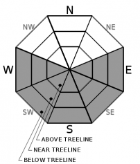
Clear overnight skies along with below freezing temperatures has provided a good refreeze to the snow surface.  On SE-S-SW aspects, strong and thick melt freeze crusts exist that should allow for good corn snow conditions through the late morning hours.  As rapid warming occurs with well above average temperatures, loose wet instabilities will become possible on E-SE-S-SW-W aspects at all elevations.  Most loose wet instabilities should be in the form of roller balls and pinwheels.  Where transitional snow exists that has not seen repeated melt freeze cycles, especially on E and W aspects, these areas could allow for more snow to be entrained with larger loose wet avalanches possible.

NW-N-NE aspects are expected to remain firm and variable today with limited amounts of softening expected.  Firm surfaces with potential fall hazards continue to exist throughout the backcountry.  NE winds may delay some snow surface softening in wind exposed locations, but in general, softening is expected to occur sooner than what has been experienced over the past couple weeks.  Small loose wet avalanches could have increased consequences where low snow conditions exist with obstacles and hazards.  Make sure your group comes up with a plan that is appropriate for the current conditions.       

recent observations

Observations were received from Round Top in the Carson Pass area, and Rose Knob in the Mt. Rose area.  About an inch of new snow fell in the southern part of the Carson Pass area on Saturday which gave a little refresh to the current conditions on northerly aspects.  Southerly aspects provided good consolidated corn snow with waning snow coverage.  On Rose Knob, corn snow existed on SE/S aspects around mid-day.  Punchy transitional snow was found on E aspects, with firm and variable snow still on northerly aspects.  Snow coverage is deteriorating quickly in this area with many obstacles and hazards below 8000'.

Weather and CURRENT CONDITIONS
weather summary

Dry conditions, sunny skies, with well above average temperatures are expected this week through Friday.  High temperatures during the day above 8000' are expected to be 40 to 50 degrees with continued below freezing overnight temperatures in the mid to high 20's.  Increasing winds with much colder temperatures are expected as a cold front moves into our area on Saturday and Sunday with the chance of a few inches of snow over the Sierra Crest.   

CONDITIONS ALONG THE SIERRA CREST BETWEEN 8200 FT. AND 9200 FT. IN THE LAST 24 HOURS
6am temperature: 24 to 30 deg. F.
Max. temperature: 35 to 46 deg. F.
Average ridgetop wind direction: NE
Average ridgetop wind speed: 25 to 45 mph
Maximum ridgetop wind gust: 64 mph
New snowfall: 0 inches
Total snow depth: 38 to 47 inches
Two-Day Mountain Weather Forecast Produced in partnership with the Reno NWS
For 7000 ft. to 8000 ft.
Tuesday Tuesday Night Wednesday
Weather: Sunny. Snow levels below 7000 feet. Chance of precipitation is 0%. Clear. Snow levels below 7000 feet. Chance of precipitation is 0%. Sunny. Snow levels below 7000 feet increasing to 7500 feet in the afternoon. Chance of precipitation is 0%.
Temperatures: 45 to 51. deg. F. 25 to 31. deg. F. 49 to 55. deg. F.
Mid Slope Winds: Light winds. Light winds. Light winds.
Expected snowfall: No accumulation. | SWE = none. No accumulation. | SWE = none. No accumulation. | SWE = none.
For 8000 ft. to 9000 ft.
Tuesday Tuesday Night Wednesday
Weather: Sunny. Snow levels below 7000 feet. Chance of precipitation is 0%. Clear. Snow levels below 7000 feet. Chance of precipitation is 0%. Sunny. Snow levels below 7000 feet increasing to 7500 feet in the afternoon. Chance of precipitation is 0%.
Temperatures: 40 to 46. deg. F. 24 to 29. deg. F. 44 to 50. deg. F.
Ridge Top Winds: East 15 to 25 mph with gusts to 50 mph. Southeast 15 to 20 mph with gusts to 35 mph. West around 15 mph with gusts to 35 mph.
Expected snowfall: No accumulation. | SWE = none. No accumulation. | SWE = none. No accumulation. | SWE = none.
Disclaimer

This avalanche forecast is provided through a partnership between the Tahoe National Forest and the Sierra Avalanche Center. This forecast covers the Central Sierra Nevada Mountains between Yuba Pass on the north and Ebbetts Pass on the south. Click here for a map of the forecast area. This forecast applies only to backcountry areas outside established ski area boundaries. This forecast describes general avalanche conditions and local variations always occur. This forecast expires 24 hours after the posted time unless otherwise noted. The information in this forecast is provided by the USDA Forest Service who is solely responsible for its content.

For a recorded version of the avalanche forecast call (530) 587-3558 x258