THIS AVALANCHE FORECAST EXPIRED ON February 27, 2020 @ 6:52 am
Avalanche Forecast published on February 26, 2020 @ 6:52 am
Issued by Steve Reynaud - Tahoe National Forest

Increasing temperatures with decreasing winds will make loose wet avalanches possible today at all elevations.  Avalanche danger will increase to MODERATE as daytime warming occurs into the mid-day and afternoon hours.

2. Moderate

?

Above Treeline
Heightened avalanche conditions on specific terrain features. Evaluate snow and terrain carefully; identify features of concern.

2. Moderate

?

Near Treeline
Heightened avalanche conditions on specific terrain features. Evaluate snow and terrain carefully; identify features of concern.

2. Moderate

?

Below Treeline
Heightened avalanche conditions on specific terrain features. Evaluate snow and terrain carefully; identify features of concern.
    Heightened avalanche conditions on specific terrain features. Evaluate snow and terrain carefully; identify features of concern.
Avalanche Problem 1: Loose Wet
  • Type ?
  • Aspect/Elevation ?
  • Likelihood ?
    Certain
    Very Likely
    Likely
    Possible
    Unlikely
  • Size ?
    Historic
    Very Large
    Large
    Small

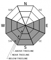
Loose wet avalanche activity is expected to increase today as daytime warming accelerates into the mid-day and afternoon hours.  A combination of near to above freezing temperatures overnight, warmer forecasted daytime high temperatures, and lighter W winds, will all lead to the snow surface softening and loosing strength throughout the day.  Thick melt freeze crusts on SE-S-SW aspects with clear overnight skies should still provide good supportable conditions throughout the morning hours.  Loose wet instabilities are expected to be mostly small, though transitional surface snow areas that do not have an established melt freeze crust may have more snow available for larger loose wet avalanches.  NW-N-NE aspects are expected to remain firm and variable in most areas with limited softening.

Monitor the snow surface softening throughout the day.  If the surface snow is becoming wet and punchy, it’s time to move to a different aspect or call it a day.  Small loose wet avalanches could still have consequences with our low snow conditions with plenty of obstacles and hazards to hit. 

recent observations

Observations came from Stevens Peak in the Carson Pass area yesterday.  Warm conditions were at the low to mid elevations with moderate NE winds keeping it cold at the upper elevations.  Snow surface softening was limited above 9500', with corn snow below 9200' on SE-S aspects.  Transitional snow existed at higher elevations and on E aspects without an established melt freeze crust.  Snow coverage is decreasing quickly on southerly aspects at all elevations.  No wet snow instabilities were observed.

Weather and CURRENT CONDITIONS
weather summary

Sunny skies with light winds will prevail into the weekend.  Well above average daytime temperatures with highs into the 60's are expected at lake level today.  Light overnight winds have allowed temperature inversions to set up with colder air in the valleys and warmer air aloft.  Remote sensors on peak tops report mostly above freezing overnight temperatures for the first time in weeks.  A cold front is expected for this weekend with increasing clouds, winds, and the chance of snow. 

CONDITIONS ALONG THE SIERRA CREST BETWEEN 8200 FT. AND 9200 FT. IN THE LAST 24 HOURS
6am temperature: 30 to 43 deg. F.
Max. temperature: 40 to 47 deg. F.
Average ridgetop wind direction: NE shifting to W
Average ridgetop wind speed: 20 to 40mph decreasing to 10 to 15 mph
Maximum ridgetop wind gust: 58 mph
New snowfall: 0 inches
Total snow depth: 38 to 47 inches
Two-Day Mountain Weather Forecast Produced in partnership with the Reno NWS
For 7000 ft. to 8000 ft.
Wednesday Wednesday Night Thursday
Weather: Sunny. Snow levels below 7000 feet increasing to 7500 feet in the afternoon. Chance of precipitation is 0%. Clear. Snow levels 8000 feet decreasing to 7000 feet after midnight. Chance of precipitation is 0%. Sunny. Snow levels below 7000 feet increasing to 7000 feet in the afternoon. Chance of precipitation is 0%.
Temperatures: 48 to 54. deg. F. 26 to 32. deg. F. 48 to 54. deg. F.
Mid Slope Winds: Light winds. Light winds. Light winds.
Expected snowfall: No accumulation. | SWE = none. No accumulation. | SWE = none. No accumulation. | SWE = none.
For 8000 ft. to 9000 ft.
Wednesday Wednesday Night Thursday
Weather: Sunny. Snow levels below 7000 feet increasing to 7500 feet in the afternoon. Chance of precipitation is 0%. Clear. Snow levels 8000 feet decreasing to 7000 feet after midnight. Chance of precipitation is 0%. Sunny. Snow levels below 7000 feet increasing to 7000 feet in the afternoon. Chance of precipitation is 0%.
Temperatures: 43 to 49. deg. F. 23 to 28. deg. F. 42 to 48. deg. F.
Ridge Top Winds: West around 15 mph with gusts to 30 mph. West around 15 mph with gusts to 25 mph in the evening becoming light. Light winds.
Expected snowfall: No accumulation. | SWE = none. No accumulation. | SWE = none. No accumulation. | SWE = none.
Disclaimer

This avalanche forecast is provided through a partnership between the Tahoe National Forest and the Sierra Avalanche Center. This forecast covers the Central Sierra Nevada Mountains between Yuba Pass on the north and Ebbetts Pass on the south. Click here for a map of the forecast area. This forecast applies only to backcountry areas outside established ski area boundaries. This forecast describes general avalanche conditions and local variations always occur. This forecast expires 24 hours after the posted time unless otherwise noted. The information in this forecast is provided by the USDA Forest Service who is solely responsible for its content.

For a recorded version of the avalanche forecast call (530) 587-3558 x258