THIS AVALANCHE FORECAST EXPIRED ON February 8, 2020 @ 6:46 am
Avalanche Forecast published on February 7, 2020 @ 6:46 am
Issued by Brandon Schwartz - Tahoe National Forest

Snow surface melt in areas of direct sun exposure will create a loose wet avalanche problem as the day progresses. MODERATE avalanche danger will develop today at all elevations.

2. Moderate

?

Above Treeline
Heightened avalanche conditions on specific terrain features. Evaluate snow and terrain carefully; identify features of concern.

2. Moderate

?

Near Treeline
Heightened avalanche conditions on specific terrain features. Evaluate snow and terrain carefully; identify features of concern.

2. Moderate

?

Below Treeline
Heightened avalanche conditions on specific terrain features. Evaluate snow and terrain carefully; identify features of concern.
    Heightened avalanche conditions on specific terrain features. Evaluate snow and terrain carefully; identify features of concern.
Avalanche Problem 1: Loose Wet
  • Type ?
  • Aspect/Elevation ?
  • Likelihood ?
    Certain
    Very Likely
    Likely
    Possible
    Unlikely
  • Size ?
    Historic
    Very Large
    Large
    Small

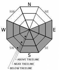
Snow surface melt as the day progresses will create a loose wet avalanche problem at all elevations mainly on E-SE-S-SW-W aspects. Avalanche size is expected mainly at D1 with an isolated D2 not impossible. When more than a couple of inches of surface wet snow is present, anticipate loose wet avalanches. Avoidance of this avalanche problem can be accomplished by the use of timing travel prior to excessive snow surface melt, utilizing lower angle slopes without steeper slopes above, and/or selecting aspects without direct sun exposure when necessary.

A good snow surface refreeze is expected to have occurred last night due to radiational cooling under clear skies despite above freezing air temperatures at the upper elevations. However, these above freezing air temperatures at sunrise will accelerate snow surface melt over the upper elevations today so factor that into your travel plans. While loose wet avalanches today are expected to be fairly small, consequences can be greatly increased by downslope hazards such as rocks, trees, cliffs, or terrain traps. Factor that into your travel plans as well.

recent observations

* Spring like snow surface conditions were observed yesterday on the south side of Slide Mtn (Mount Rose area). Breakable crusts were widespread in shaded areas. Snow surface melt was observed in areas of direct sun exposure. Some areas of transitional wet snow over drier snow yet to have undergone a melt cycle remained, but likely became increasingly assimilated with the melt-freeze surface snow by the end of the day.

* Northerly aspects remain more variable with a patchy mix of wind drifted snow and crust near or at the snow surface. Faceted snow has been noted below these near surface to surface crusts in a variety of locations on northerly aspects. This weak snow is without a problematic overlying slab for the time being.

* Little to no snow is available for wind drifting in ridgetop areas.

Weather and CURRENT CONDITIONS
weather summary

High pressure is in place over the forecast area for sunny and warm conditions today and tomorrow. Air temperature inversion conditions set up last night with below freezing temperatures on the mountain valley floors and above freezing air temperatures at the upper elevations. Ridgetop winds are expected to shift from the N and NE today to SW and remain light to moderate speed. SW ridgetop winds are forecast to increase in speed tomorrow ahead of an approaching cold front. Frontal passage is expected to occur late Saturday night into early Sunday morning bringing abrupt cooling and 1 to 2 inches of snowfall. Winds will then shift back to the NE and increase to gale force for Sunday into Monday with a forecast for 100 mph ridgetop gusts.

CONDITIONS ALONG THE SIERRA CREST BETWEEN 8200 FT. AND 9200 FT. IN THE LAST 24 HOURS
6am temperature: 33 to 36 deg. F.
Max. temperature: 38 to 46 deg. F.
Average ridgetop wind direction: NE
Average ridgetop wind speed: 30 mph
Maximum ridgetop wind gust: 57 mph
New snowfall: 0 inches
Total snow depth: 42 to 52 inches
Two-Day Mountain Weather Forecast Produced in partnership with the Reno NWS
For 7000 ft. to 8000 ft.
Friday Friday Night Saturday
Weather: Sunny skies. Chance of precipitation is 0%. Clear skies. Chance of precipitation is 0%. Sunny skies. Chance of precipitation is 0%.
Temperatures: 44 to 52. deg. F. 24 to 29. deg. F. 44 to 49. deg. F.
Mid Slope Winds: Light winds. Gusts up to 25 mph in the morning. Light winds becoming southwest around 15 mph with gusts to 45 mph after midnight. Southwest 15 to 25 mph with gusts to 60 mph.
Expected snowfall: No accumulation. | SWE = none. No accumulation. | SWE = none. No accumulation. | SWE = none.
For 8000 ft. to 9000 ft.
Friday Friday Night Saturday
Weather: Sunny skies. Chance of precipitation is 0%. Clear skies. Chance of precipitation is 0%. Sunny skies. Chance of precipitation is 0%.
Temperatures: 39 to 47. deg. F. 22 to 27. deg. F. 39 to 45. deg. F.
Ridge Top Winds: West around 15 mph with gusts to 30 mph in the morning becoming light. Southwest 15 to 20 mph. Gusts up to 25 mph increasing to 45 mph after midnight. Southwest 15 to 25 mph increasing to 20 to 35 mph in the afternoon. Gusts up to 60 mph.
Expected snowfall: No accumulation. | SWE = none. No accumulation. | SWE = none. No accumulation. | SWE = none.
Disclaimer

This avalanche forecast is provided through a partnership between the Tahoe National Forest and the Sierra Avalanche Center. This forecast covers the Central Sierra Nevada Mountains between Yuba Pass on the north and Ebbetts Pass on the south. Click here for a map of the forecast area. This forecast applies only to backcountry areas outside established ski area boundaries. This forecast describes general avalanche conditions and local variations always occur. This forecast expires 24 hours after the posted time unless otherwise noted. The information in this forecast is provided by the USDA Forest Service who is solely responsible for its content.

For a recorded version of the avalanche forecast call (530) 587-3558 x258