THIS AVALANCHE FORECAST EXPIRED ON January 13, 2020 @ 6:59 am
Avalanche Forecast published on January 12, 2020 @ 6:59 am
Issued by Andy Anderson - Tahoe National Forest - Sierra Avalanche Center

Unstable slabs of wind drifted snow may still exist on leeward facing slopes in near and above treeline terrain. Human triggered wind slab avalanches remain possible today. MODERATE avalanche danger exists near and above treeline with LOW avalanche danger below treeline.

2. Moderate

?

Above Treeline
Heightened avalanche conditions on specific terrain features. Evaluate snow and terrain carefully; identify features of concern.

2. Moderate

?

Near Treeline
Heightened avalanche conditions on specific terrain features. Evaluate snow and terrain carefully; identify features of concern.

1. Low

?

Below Treeline
Generally safe avalanche conditions. Watch for unstable snow on isolated terrain features.
    Heightened avalanche conditions on specific terrain features. Evaluate snow and terrain carefully; identify features of concern.
Avalanche Problem 1: Wind Slab
  • Type ?
  • Aspect/Elevation ?
  • Likelihood ?
    Certain
    Very Likely
    Likely
    Possible
    Unlikely
  • Size ?
    Historic
    Very Large
    Large
    Small

Stong SW winds have drifted the recent snow onto wind-exposed NW-N-NE-E-SE aspects. Adding a person's weight to these slabs of wind drifted snow could still result in a wind slab avalanche. In most areas, these wind slabs should remain small and may only knock a person off balance (D1). In the areas that received the most snow in recent days, human triggered wind slab avalanches could involve enough snow to bury or injure a person (D2).  

Stay alert for areas where possibly unstable wind slabs may exist by looking for clues like cornices above a slope, drifted snow, scoured ridges with smooth snow on one side, and wind-created surface textures. Use this information to plan travel routes with safety margins that appropriately manage this potential hazard. 

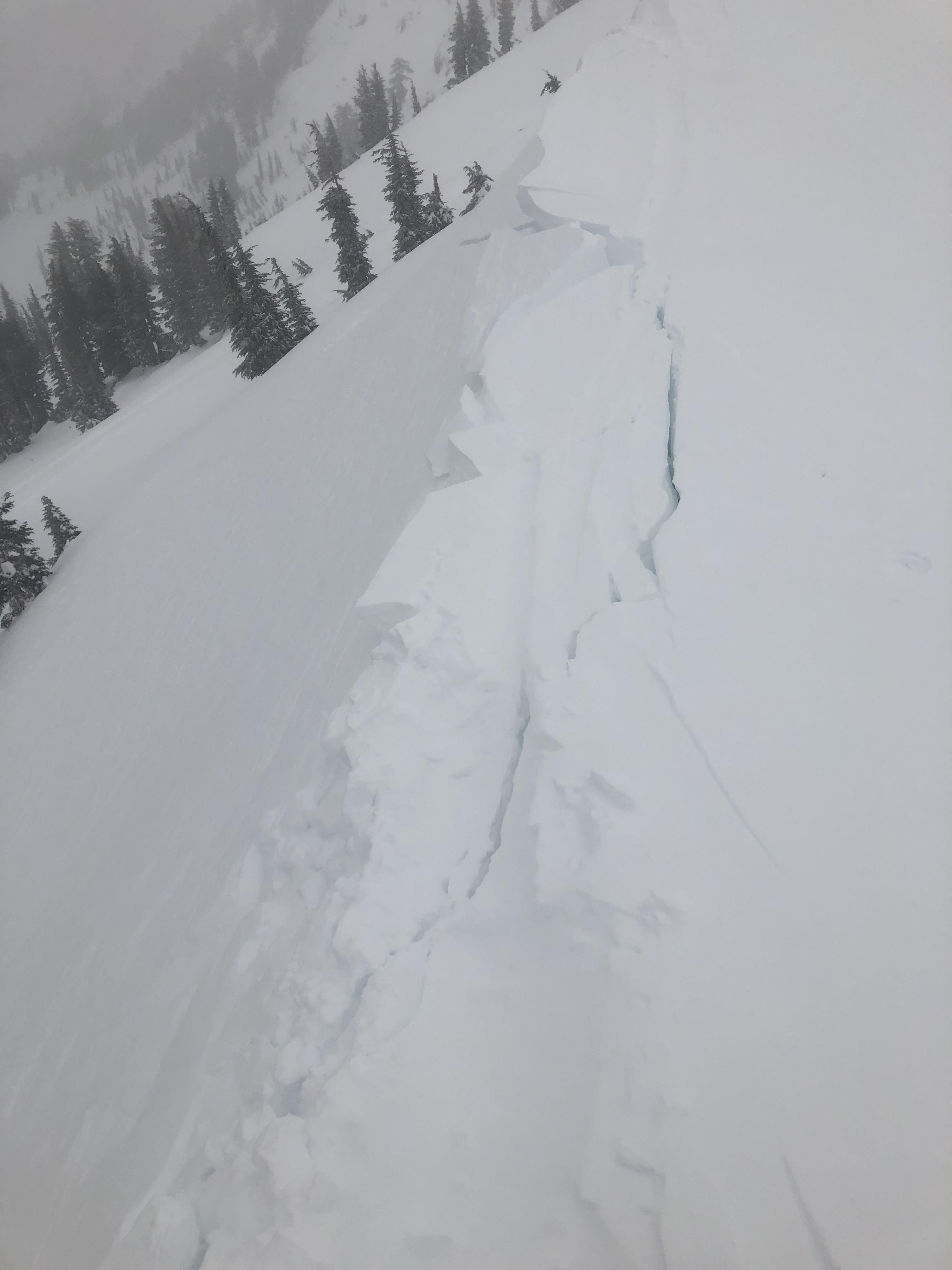
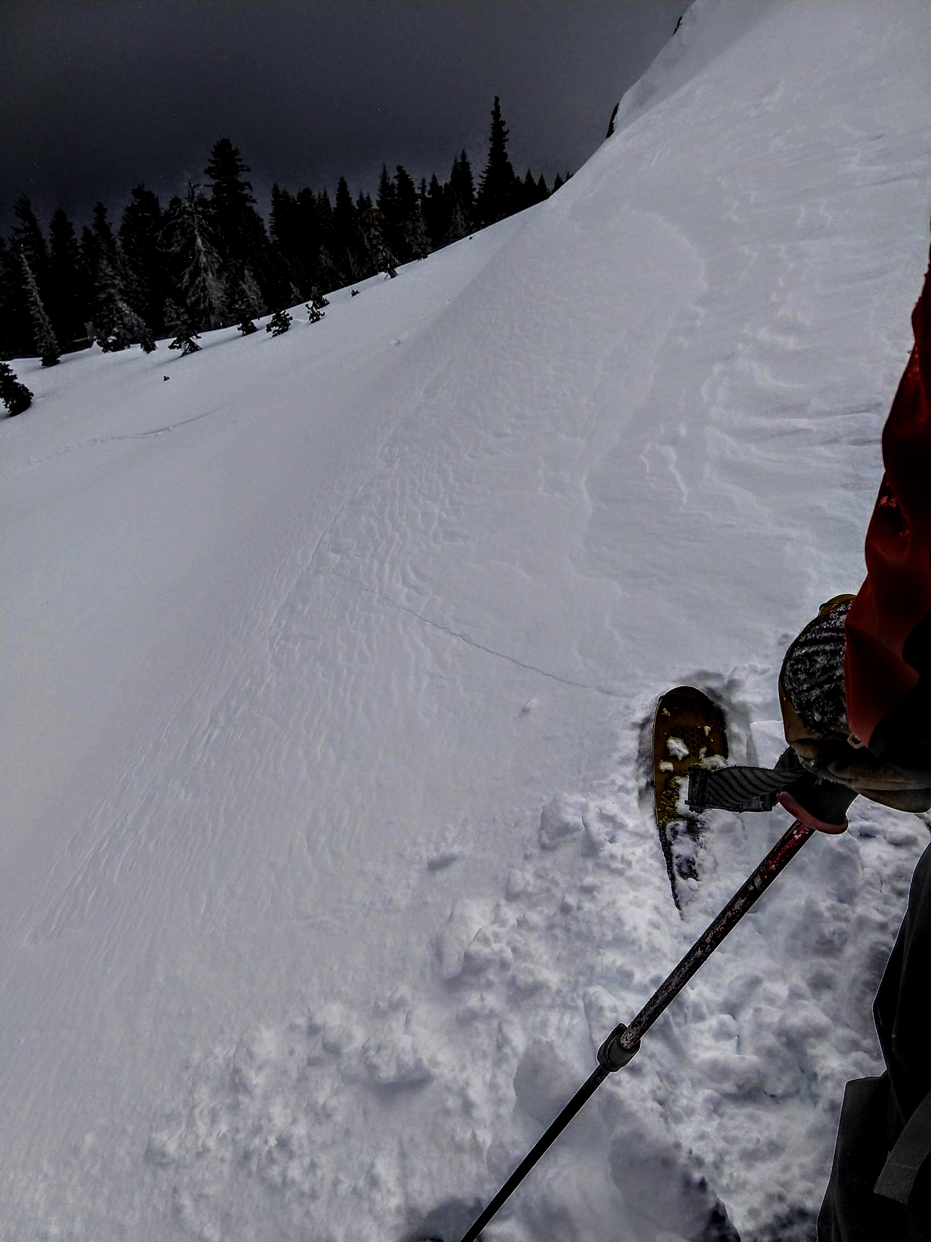
Large cornice triggered shooting cracks   Skier triggered shooting cracks

Photos: Cornice and human triggered shooting cracks in wind slabs on Castle and Andesite yesterday.

recent observations

* In wind-exposed terrain on Castle Peak and Andesite Peak yesterday, large shooting cracks occurred on wind-loaded slopes. Most of the skier triggered cracks extended 10 to 20 ft. One cornice dropped onto a slope on Castle triggered shooting cracks 70 ft wide. Observers also reported seeing wind slab avalanches on steeper slopes nearby. Wind slabs in these areas measured between 10 and 24 inches deep. Small inconsequential areas of wind drifted snow also existed on Echo Summit where less new snow accumulated. 

* A layer of weak snow (facets) still exists near the Dec 12 and Jan 4 rain crusts. This layer does not have a slab on top of it yet, but snowpit tests that simulate adding new snow (like what we are forecasted to get later this week) indicate that this layer could fail. Check out the loaded PST video from Jan 10.

* Consolidated snow exists in the middle and lower portions of the snowpack and should handle the new snow loading well.

Weather and CURRENT CONDITIONS
weather summary

Yesterday, Donner Summit reported 3 to 4 inches while other areas including the east side of the lake reported 0 to 3 inches. Strong SW winds continued for much of the day before shifting to the NE and decreasing between 7 pm and midnight. Then they shifted back to the SW for today. The forecast calls for a series of progressively strong storms to impact the region this week. The first and weakest should arrive tonight with a few inches of snow. The second moderate storm should move in on Monday afternoon and last through Tuesday with a possibility of 5-10 inches of snow along the Sierra Crest and strong winds. The strongest storm arrives Wednesday evening and could bring feet of snow and gale-force winds to the mountains. For more details check in with the Reno NWS

CONDITIONS ALONG THE SIERRA CREST BETWEEN 8200 FT. AND 9200 FT. IN THE LAST 24 HOURS
6am temperature: 14 to 22 deg. F.
Max. temperature: 21 to 28 deg. F.
Average ridgetop wind direction: SW
Average ridgetop wind speed: 30 mph
Maximum ridgetop wind gust: 87 mph
New snowfall: 0 to 4 inches
Total snow depth: 41 to 45 inches
Two-Day Mountain Weather Forecast Produced in partnership with the Reno NWS
For 7000 ft. to 8000 ft.
Sunday Sunday Night Monday
Weather: Partly cloudy then becoming mostly cloudy. Slight chance of snow in the afternoon. Snow levels below 7000 feet. Chance of precipitation is 10%. Mostly cloudy. Chance of snow. Snow levels below 7000 feet. Chance of precipitation is 50%. Mostly cloudy then becoming partly cloudy. Slight chance of snow. Snow levels below 7000 feet. Chance of precipitation is 15%.
Temperatures: 28 to 33 deg. F. 18 to 23 deg. F. 30 to 36 deg. F.
Mid Slope Winds: Southwest 15 to 25 mph. Gusts up to 35 mph increasing to 50 mph in the afternoon. Southwest 20 to 35 mph with gusts to 70 mph. Southwest 15 to 25 mph with gusts to 50 mph.
Expected snowfall: No accumulation. | SWE = none. 80% probability of 1 to 4 inches. 20% probability of 4 to 6 inches. | SWE = up to 0.15 inch. 20% probability up to 1 inch. 80% probability no accumulation. | SWE = trace amounts.
For 8000 ft. to 9000 ft.
Sunday Sunday Night Monday
Weather: Partly cloudy then becoming mostly cloudy. Slight chance of snow in the afternoon. Snow levels below 7000 feet. Chance of precipitation is 10%. Mostly cloudy. Chance of snow. Snow levels below 7000 feet. Chance of precipitation is 50%. Mostly cloudy then becoming partly cloudy. Slight chance of snow. Snow levels below 7000 feet. Chance of precipitation is 15%.
Temperatures: 24 to 30 deg. F. 15 to 20 deg. F. 26 to 32 deg. F.
Ridge Top Winds: Southwest 20 to 35 mph with gusts to 60 mph. Southwest 30 to 50 mph with gusts to 75 mph. Southwest 25 to 35 mph with gusts to 60 mph.
Expected snowfall: No accumulation. | SWE = none. 80% probability of 1 to 4 inches. 20% probability of 4 to 6 inches. | SWE = up to 0.15 inch. 20% probability up to 1 inch. 80% probability no accumulation. | SWE = trace amounts.
Disclaimer

This avalanche forecast is provided through a partnership between the Tahoe National Forest and the Sierra Avalanche Center. This forecast covers the Central Sierra Nevada Mountains between Yuba Pass on the north and Ebbetts Pass on the south. Click here for a map of the forecast area. This forecast applies only to backcountry areas outside established ski area boundaries. This forecast describes general avalanche conditions and local variations always occur. This forecast expires 24 hours after the posted time unless otherwise noted. The information in this forecast is provided by the USDA Forest Service who is solely responsible for its content.

For a recorded version of the avalanche forecast call (530) 587-3558 x258