THIS AVALANCHE FORECAST EXPIRED ON January 3, 2020 @ 6:56 am
Avalanche Forecast published on January 2, 2020 @ 6:56 am
Issued by Brandon Schwartz - Tahoe National Forest

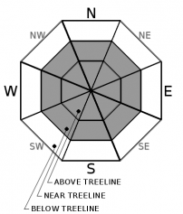
MODERATE avalanche danger lingers above 9,000' in above treeline and near treeline terrain due to shallow slabs of wind drifted snow (wind slabs). Anticipate a travel hazard today with rain crust on all aspects up to about 9,000' making long sliding falls possible. LOW avalanche danger exists for areas below 9,000' and for below treeline terrain.

2. Moderate

?

Above Treeline
Heightened avalanche conditions on specific terrain features. Evaluate snow and terrain carefully; identify features of concern.

2. Moderate

?

Near Treeline
Heightened avalanche conditions on specific terrain features. Evaluate snow and terrain carefully; identify features of concern.

1. Low

?

Below Treeline
Generally safe avalanche conditions. Watch for unstable snow on isolated terrain features.
    Heightened avalanche conditions on specific terrain features. Evaluate snow and terrain carefully; identify features of concern.
Avalanche Problem 1: Wind Slab
  • Type ?
  • Aspect/Elevation ?
  • Likelihood ?
    Certain
    Very Likely
    Likely
    Possible
    Unlikely
  • Size ?
    Historic
    Very Large
    Large
    Small

For areas above 9,000', shallow wind slabs may linger in near treeline and above treeline terrain on all aspects. Recent strong to gale force ridgetop winds have shifted between SW to W and NE to E over the past several days. Light to moderate amounts of blowing and drifting snow has been observed in recent days with about an inch of new snow above the rain/snow line yesterday. A mix of hard slab and soft slab conditions exist. Any shallow wind slab avalanches that occur today are expected to be D1 in size. Evaluate other terrain features such as cliffs below, rocks, trees, and terrain traps that would magnify the consequences of an otherwise small avalanche.

Other things to consider: 1) Newly formed rain crust below about 9,000' may present a travel hazard today. Firm conditions could make long sliding falls possible or breakable crust may be encountered. 2) It is unlikely but not impossible that warming today may be sufficient to melt the rain crust on some SE-S-SW aspects, allowing for roller balls and small loose wet avalanches.

recent observations

* An unforecast rain event occurred yesterday across the forecast area with 0.1 to 0.15 inches of rain up to about 9,000'. Around an inch of snow fell above the rain/snow line.

* The top 1 to 2 inches of the snowpack was wetted by yesterday's rain below about 9,000' with roller balls reported below treeline.

* New rain crust was observed forming on the surface yesterday afternoon as snow surface refreeze occurred. Expect firm to breakable crust conditions on all aspects today up to about 9,000'.

* Thin wind slab was reported yesterday beneath cornice on Incline Peak at 9,400' on a NE aspect.

Weather and CURRENT CONDITIONS
weather summary

Following yesterday's unforecast rain event, weak high pressure will allow for sunshine and some high clouds today and tomorrow. Ridgetop winds shifted from W to NE yesterday evening and are moderate speed this morning. Light to moderate speed ridgetop winds are forecast for later today with a shift to the SW tomorrow. Friday night winds are expected to increase back to strong to gale force in speed over the ridgetops. Air temperatures are expected to warm into the 40s for many locations today and tomorrow.

CONDITIONS ALONG THE SIERRA CREST BETWEEN 8200 FT. AND 9200 FT. IN THE LAST 24 HOURS
6am temperature: 25 to 30 deg. F.
Max. temperature: 36 to 38 deg. F.
Average ridgetop wind direction: W shifting to NE
Average ridgetop wind speed: W 38 mph | NE 35 mph
Maximum ridgetop wind gust: W 72 mph | NE 62 mph
New snowfall: 0 to 1 inch | SWE 0.1 to 0.15 inches
Total snow depth: 44 to 47 inches
Two-Day Mountain Weather Forecast Produced in partnership with the Reno NWS
For 7000 ft. to 8000 ft.
Thursday Thursday Night Friday
Weather: Partly cloudy. Snow levels below 7000 feet. Chance of precipitation is 0%. Partly cloudy. Snow levels below 7000 feet. Chance of precipitation is 0%. Mostly cloudy then becoming partly cloudy. Snow levels below 7000 feet increasing to 7000 feet in the afternoon. Chance of precipitation is 0%.
Temperatures: 40 to 45. deg. F. 19 to 24. deg. F. 43 to 48. deg. F.
Mid Slope Winds: Light winds. Gusts up to 25 mph in the morning. Light winds. Light winds becoming southwest around 15 mph with gusts to 30 mph in the afternoon.
Expected snowfall: No accumulation. | SWE = none. No accumulation. | SWE = none. No accumulation. | SWE = none.
For 8000 ft. to 9000 ft.
Thursday Thursday Night Friday
Weather: Partly cloudy. Snow levels below 7000 feet. Chance of precipitation is 0%. Partly cloudy. Snow levels below 7000 feet. Chance of precipitation is 0%. Partly cloudy. Snow levels below 7000 feet increasing to 7500 feet in the afternoon. Chance of precipitation is 0%.
Temperatures: 36 to 41. deg. F. 20 to 25. deg. F. 40 to 45. deg. F.
Ridge Top Winds: North 15 to 30 mph. Gusts up to 45 mph decreasing to 35 mph in the afternoon. East 15 to 25 mph with gusts to 35 mph. Light winds becoming southwest 15 to 20 mph with gusts to 35 mph in the afternoon.
Expected snowfall: No accumulation. | SWE = none. No accumulation. | SWE = none. No accumulation. | SWE = none.
Disclaimer

This avalanche forecast is provided through a partnership between the Tahoe National Forest and the Sierra Avalanche Center. This forecast covers the Central Sierra Nevada Mountains between Yuba Pass on the north and Ebbetts Pass on the south. Click here for a map of the forecast area. This forecast applies only to backcountry areas outside established ski area boundaries. This forecast describes general avalanche conditions and local variations always occur. This forecast expires 24 hours after the posted time unless otherwise noted. The information in this forecast is provided by the USDA Forest Service who is solely responsible for its content.

For a recorded version of the avalanche forecast call (530) 587-3558 x258