THIS AVALANCHE FORECAST EXPIRED ON January 21, 2020 @ 7:00 am
Avalanche Forecast published on January 20, 2020 @ 7:00 am
Issued by Andy Anderson - Tahoe National Forest - Sierra Avalanche Center

Loose sugary snow 2 ft below the surface (or deeper in areas with wind drifted snow) has resulted in unusual avalanche conditions with significant uncertainty and the potential for large avalanches with severe consequences. Conservative route finding that avoids steeper terrain represents the best travel advice right now especially with soft snow still lingering on lower angle terrain. Some unstable wind drifted snow may exist at upper elevations. CONSIDERABLE danger continues below and near treeline with MODERATE danger above treeline.

2. Moderate

?

Above Treeline
Heightened avalanche conditions on specific terrain features. Evaluate snow and terrain carefully; identify features of concern.

3. Considerable

?

Near Treeline
Dangerous avalanche conditions. Careful snowpack evaluation, cautious route-finding and conservative decision-making essential.

3. Considerable

?

Below Treeline
Dangerous avalanche conditions. Careful snowpack evaluation, cautious route-finding and conservative decision-making essential.
    Dangerous avalanche conditions. Careful snowpack evaluation, cautious route-finding and conservative decision-making essential.
Avalanche Problem 1: Persistent Slab
  • Type ?
  • Aspect/Elevation ?
  • Likelihood ?
    Certain
    Very Likely
    Likely
    Possible
    Unlikely
  • Size ?
    Historic
    Very Large
    Large
    Small

Human-triggered avalanches that fail on weak snow (facets) buried about 2ft deep in sheltered areas and much deeper where wind drifted snow exists above it (up to 8 ft) remain possible today. These avalanches would be large (D2-D3). They could have severe consequences including trauma from collisions with trees or terrain features. They could propagate farther than expected and break above or behind the person who triggers them. In some places, these persistent slab avalanches may become easier to trigger as the recent snow consolidates into more of a slab layer above the persistent weak layer.

Near and below treeline NW-N-NE-E facing slopes represent the most likely places to find this problem. However, observers have found it in a few isolated areas in more exposed upper elevation terrain. Predicting exactly which slopes these persistent slab avalanches will occur on is impossible. Some slopes may have numerous tracks on them and not release, others may release with the first person on the slope, and others may release after several people have already used the slope. 

Recent avalanches, cracking, snowpack collapse or whumfing, or unstable snowpit test results, can indicate a persistent slab problem, but in many cases, triggering a persistent slab avalanche is the first sign of instability. If you have any uncertainty about whether or not this layer exists on a slope, it is best to just avoid it and pick something else.

Due to the uncertainty and severe consequeces associated with persistent slabs we still recommend avoidance by choosing lower angle terrain (maximum slope angles less than 30 degrees) without steeper terrain above or to the side. Low angle due N facing slopes still hold soft snow that provides excellent skiing, snowmobiling, and snowboarding experiences.

See the photos below for some of the recent avalanches triggered on this layer.


Avalanche Problem 2: Wind Slab
  • Type ?
  • Aspect/Elevation ?
  • Likelihood ?
    Certain
    Very Likely
    Likely
    Possible
    Unlikely
  • Size ?
    Historic
    Very Large
    Large
    Small

Some unstable slabs of wind drifted snow may still linger on steep wind-loaded slopes especially in complex or extreme terrain. With increased winds today, some new wind-loading may occur at upper elevations.

Identify where wind slabs might exist by using clues like recent avalanche activity, cracking in drifted snow, cornices above a slope, wind drifted snow, and wind textured surfaces. Use this information to build safety margins and travel routes to manage this problem appropriately.

recent observations

* Several D2 avalanches have occurred on the Jan 4 crust/facet persistent weak layer since Jan 15. Another human-triggered avalanche was reported yesterday in the Silver Peak area on a steep NE facing slope below treeline. It is unclear if this one occurred yesterday or on Friday or Saturday.  

* The Jan 4 crust/facet persistent weak layer continues to exhibit signs of instability across the forecast area. Skier triggered snowpack collapse with whumpfing occurred yesterday on E-NE-N aspects Trimmer Peak and on Stoney Ridge. Observers reported unstable test results on E-NE-N aspects in the Donner Summit area, the Mt. Rose backcountry, and in the backcountry near Heavenly.

* The Jan 4 crust/facet weak layer is most prevalent and widespread in the 7,000' to 9,000' elevation range but has also been observed at higher elevations in more isolated distribution.

* Observers reported some minor wind slab instability in some areas.

* Warm wet snow surfaces existed on most aspects by yesterday afternoon and some small roller-ball activity did occur.

Weather and CURRENT CONDITIONS
weather summary

The forecast calls for another warm and cloudy day today with stronger SW winds. These winds should continue through tonight before increasing again with tomorrow's storm. This small storm could bring 2-5 inches of new snow to the Sierra Crest by Wed. morning. Cooler temperatures and stronger SW winds should also accompany this system. 

CONDITIONS ALONG THE SIERRA CREST BETWEEN 8200 FT. AND 9200 FT. IN THE LAST 24 HOURS
6am temperature: 32 to 37 deg. F.
Max. temperature: 42 to 48 deg. F.
Average ridgetop wind direction: SW
Average ridgetop wind speed: 20 mph
Maximum ridgetop wind gust: 62 mph
New snowfall: 0 inches
Total snow depth: 46 to 56 inches
Two-Day Mountain Weather Forecast Produced in partnership with the Reno NWS
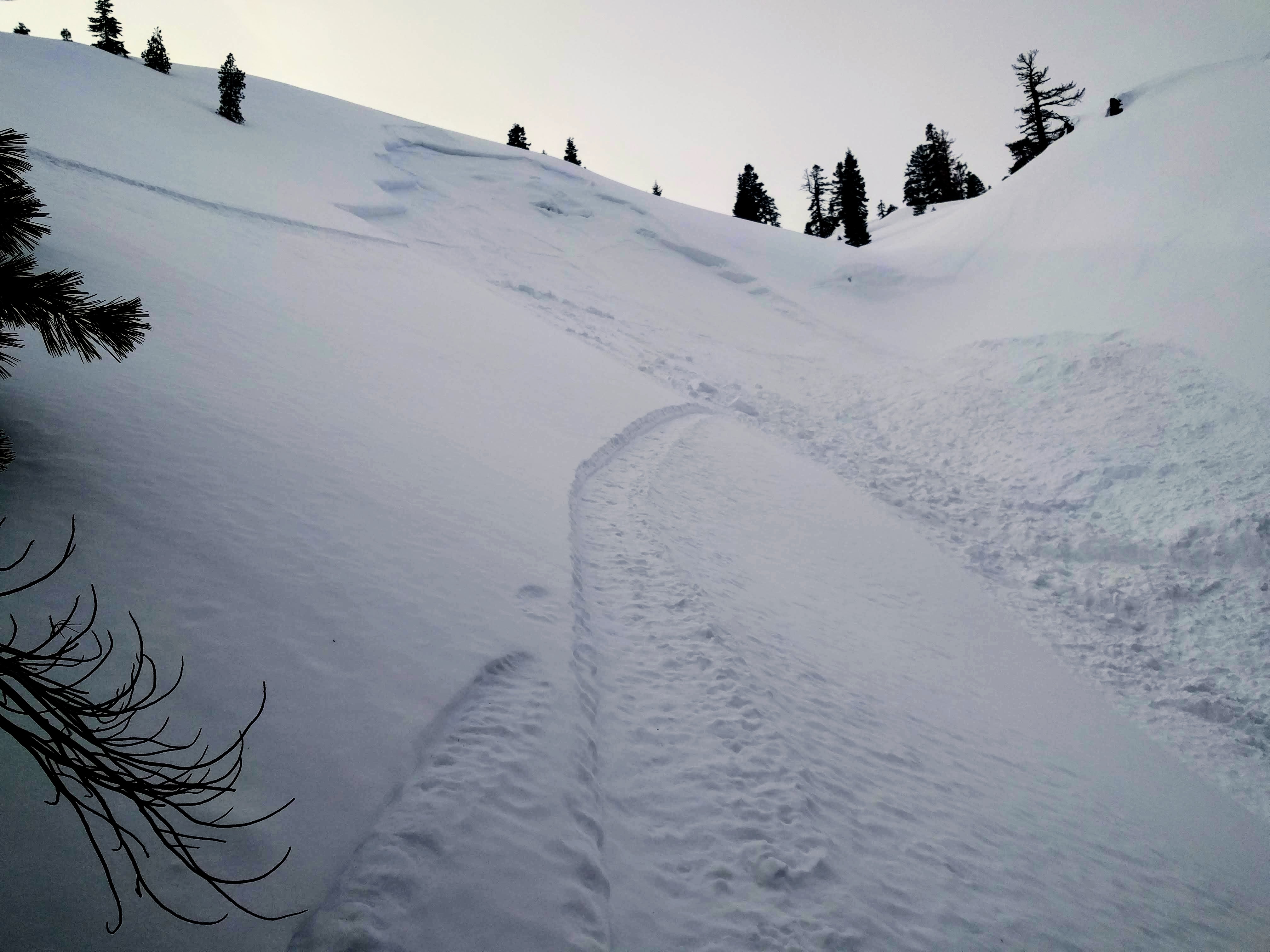
For 7000 ft. to 8000 ft.
Monday Monday Night Tuesday
Weather: Mostly cloudy. Slight chance of snow in the afternoon. Snow levels below 7000 feet. Chance of precipitation is 15%. Mostly cloudy then becoming partly cloudy. Snow levels below 7000 feet. Chance of precipitation is 10%. Mostly cloudy. Chance of snow in the morning, then snow in the afternoon. Snow levels below 7000 feet. Chance of precipitation is 75%.
Temperatures: 37 to 42 deg. F. 23 to 28 deg. F. 33 to 38 deg. F.
Mid Slope Winds: South around 15 mph with gusts to 35 mph. Southwest 15 to 20 mph. Gusts up to 40 mph. Southwest 15 to 25 mph. Gusts up to 50 mph.
Expected snowfall: No accumulation. | SWE = trace amounts. No accumulation. | SWE = none. 70% probability of 1 to 3 inches. 30% probability of 3 to 6 inches. | SWE = up to 0.15 inch.
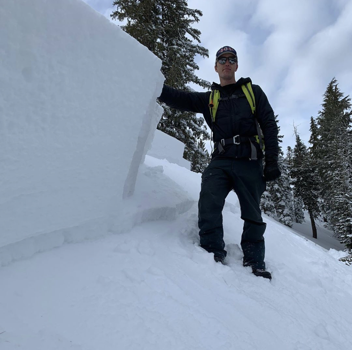
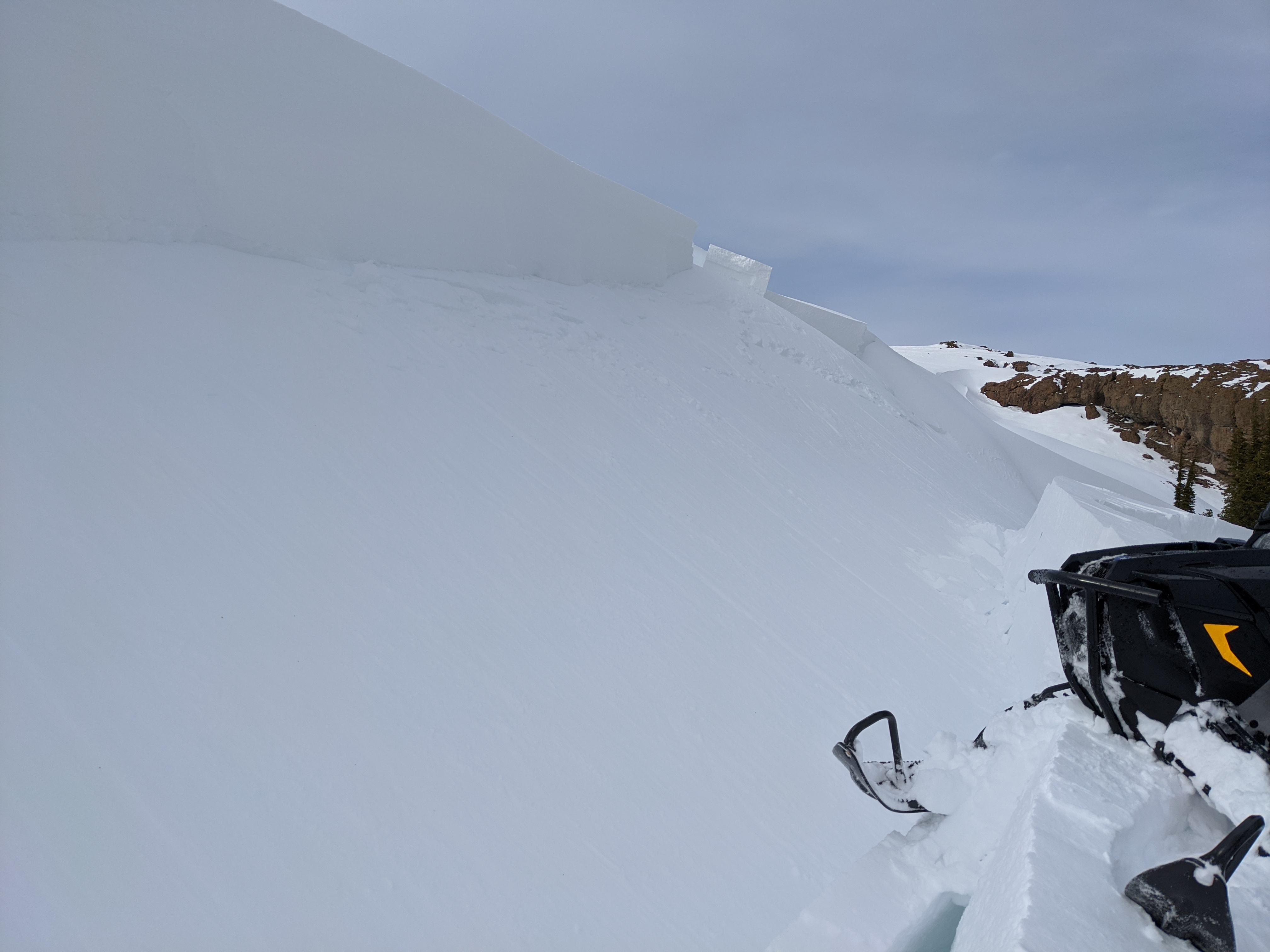
For 8000 ft. to 9000 ft.
Monday Monday Night Tuesday
Weather: Mostly cloudy. Slight chance of snow in the afternoon. Snow levels below 7000 feet. Chance of precipitation is 15%. Mostly cloudy then becoming partly cloudy. Snow levels below 7000 feet. Chance of precipitation is 10%. Mostly cloudy. Chance of snow in the morning, then snow in the afternoon. Snow levels below 7000 feet. Chance of precipitation is 75%.
Temperatures: 32 to 38 deg. F. 20 to 25 deg. F. 28 to 34 deg. F.
Ridge Top Winds: South 20 to 30 mph with gusts to 60 mph. Southwest 20 to 30 mph with gusts to 60 mph. Southwest 30 to 40 mph with gusts to 85 mph.
Expected snowfall: No accumulation. | SWE = trace amounts. No accumulation. | SWE = none. 70% probability of 1 to 3 inches. 30% probability of 3 to 6 inches. | SWE = up to 0.20 inch.
Disclaimer

This avalanche forecast is provided through a partnership between the Tahoe National Forest and the Sierra Avalanche Center. This forecast covers the Central Sierra Nevada Mountains between Yuba Pass on the north and Ebbetts Pass on the south. Click here for a map of the forecast area. This forecast applies only to backcountry areas outside established ski area boundaries. This forecast describes general avalanche conditions and local variations always occur. This forecast expires 24 hours after the posted time unless otherwise noted. The information in this forecast is provided by the USDA Forest Service who is solely responsible for its content.

For a recorded version of the avalanche forecast call (530) 587-3558 x258