


For 7000 ft. to 8000 ft.
| Friday | Friday Night | Saturday | |
|---|---|---|---|
| Weather: | Mostly cloudy then becoming partly cloudy. Isolated showers in the morning. Snow levels 7500 feet decreasing to below 7000 feet in the afternoon. Chance of precipitation is 20%. | Mostly cloudy. Snow levels below 7000 feet. Chance of precipitation is 0%. | Mostly cloudy. Snow levels 7000 feet increasing to 8000 feet in the afternoon. Chance of precipitation is 5%. |
| Temperatures: | 37 to 42. deg. F. | 25 to 30. deg. F. | 42 to 47. deg. F. |
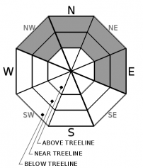
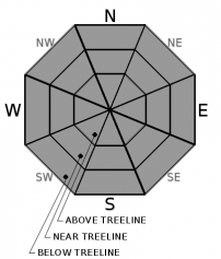
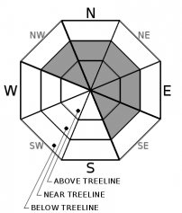
| Mid Slope Winds: | Southwest 10 to 20 mph with gusts to 35 mph. | West to southwest up to 10 mph. | Light winds. |
| Expected snowfall: | Up to 1 inch. | SWE = less than 0.10 inch. | No accumulation. | SWE = none. | No accumulation. | SWE = none. |
For 8000 ft. to 9000 ft.
| Friday | Friday Night | Saturday | |
|---|---|---|---|
| Weather: | Mostly cloudy then becoming partly cloudy. Isolated snow showers in the morning. Snow levels 7500 feet decreasing to below 7000 feet in the afternoon. Chance of precipitation is 20%. | Mostly cloudy. Snow levels below 7000 feet. Chance of precipitation is 0%. | Mostly cloudy. Snow levels 7000 feet increasing to 8000 feet in the afternoon. Chance of precipitation is 5%. |
| Temperatures: | 33 to 39. deg. F. | 23 to 28. deg. F. | 38 to 44. deg. F. |
| Ridge Top Winds: | Southwest 20 to 35 mph with gusts to 55 mph. | Southwest 15 to 25 mph with gusts to 40 mph. | Southwest 10 to 20 mph. |
| Expected snowfall: | 80% probability up to 1 inch. 20% probability of 1 to 2 inches. | SWE = less than 0.15 inch. | No accumulation. | SWE = none. | No accumulation. | SWE = none. |


