THIS AVALANCHE FORECAST EXPIRED ON January 27, 2020 @ 7:00 am
Avalanche Forecast published on January 26, 2020 @ 7:00 am
Issued by Andy Anderson - Tahoe National Forest - Sierra Avalanche Center

Slabs of wind drifted snow at upper elevations and sluffs of wet snow at lower elevations are possible today. New loading on the persistent weak layer of crust and sugary faceted snow means that higher consequence avalanches may also be possible today. Avalanche danger is MODERATE for all elevations.

2. Moderate

?

Above Treeline
Heightened avalanche conditions on specific terrain features. Evaluate snow and terrain carefully; identify features of concern.

2. Moderate

?

Near Treeline
Heightened avalanche conditions on specific terrain features. Evaluate snow and terrain carefully; identify features of concern.

2. Moderate

?

Below Treeline
Heightened avalanche conditions on specific terrain features. Evaluate snow and terrain carefully; identify features of concern.
    Heightened avalanche conditions on specific terrain features. Evaluate snow and terrain carefully; identify features of concern.
Avalanche Problem 1: Wind Slab
  • Type ?
  • Aspect/Elevation ?
  • Likelihood ?
    Certain
    Very Likely
    Likely
    Possible
    Unlikely
  • Size ?
    Historic
    Very Large
    Large
    Small

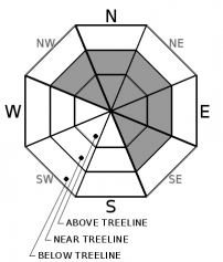
New slabs of wind drifted snow should have started to form on leeward aspects at upper elevations during the night. These wind slabs should become slightly larger and more widespread as more snow accumulates and snow levels fall today. Human-triggered wind slab avalanches will be possible today. The largest and most fragile wind slabs will exist on wind-loaded NW-N-NE-E-SE aspects in near and above treeline terrain. Large cornices also exist above many wind-loaded slopes.

Identify where wind slabs may exist by looking for signs of wind-loading like blowing snow, snow drifts, cornices above a slope and other wind created features. Use this information to avoid the areas where these fragile wind slabs may exist.  

Avalanche Problem 2: Persistent Slab
  • Type ?
  • Aspect/Elevation ?
  • Likelihood ?
    Certain
    Very Likely
    Likely
    Possible
    Unlikely
  • Size ?
    Historic
    Very Large
    Large
    Small

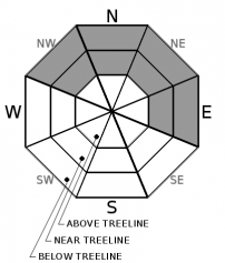
Recent data has indicated increased variability in the strength of the Jan 4th persistent weak layer. In some areas, it has gained strength. In other areas, it remains weak. Avalanche activity has not been reported on this layer for several days. The rain and snow from last night and today may add enough weight to the snowpack to reactivate this weak layer of sugary snow (facets) in some places today. This layer is most prevalent on the near and below treeline NW-N-NE-E aspects. It is typically buried 1 to 2 feet below the snow surface except in a few areas where drifted snow has buried it much deeper. Some human triggered avalanches may be possible on this layer again today.

Any avalanches that do occur on this layer would have severe consequences. Due to these consequences and a high degree of uncertainty surrounding this layer, conservative terrain selection is recommended anywhere you suspect this layer exists.

Avalanche Problem 3: Loose Wet
  • Type ?
  • Aspect/Elevation ?
  • Likelihood ?
    Certain
    Very Likely
    Likely
    Possible
    Unlikely
  • Size ?
    Historic
    Very Large
    Large
    Small

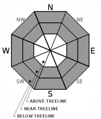
Wet snow and rain on snow at lower elevations mean that small sluffs of wet snow may be possible today below 7500 ft. These loose wet avalanches should become less likely as temperatures cool off throughout the day. 

recent observations

Observers reported more variable results on the Jan 4 persistent weak layer. Snowpit tests yielded unstable results on Relay Peak and Stevens Peak. MIxed results (some unstable, some not unstable) occurred on Slide Mountain, Yuba Pass, and near Independence Lake. Non-reactive tests occurred on Powderhouse and in Hope Valley. Overall data has indicated that this layer has become highly variable. It remains weak in some areas but has gained strength in others.

Firm rain crusts gave way to wet snow and breakable crusts across the forecast area yesterday. Spring-like conditions were reported on sunny slopes by yesterday afternoon in the Mt. Rose area and the Hope Valley area. One party reported a small loose wet avalanche on Mt. Houghton. Another party saw debris from a recent cornice collapse on Donner Summit.

Weather and CURRENT CONDITIONS
weather summary

A weak storm system arrived over the region last night. The precipitation started as rain up to around 8800 ft. As the storm has continued, snow levels have fallen to around 7200 ft as of this morning. So far about .3 to .5 inches of precipitation has fallen with most of that falling as rain below 7500 ft and some of it accumulating as 1 to 3 inches of new snow above 7500 ft. Precipitation should continue through today and snow levels should fall below 7000 ft by mid-morning. The forecast calls for another 1 to 4 inches of new snow above 7000 ft. This storm should move out of the region by tonight. Expect partly cloudy skies and decreased winds as a small ridge builds over the region on Monday.  

CONDITIONS ALONG THE SIERRA CREST BETWEEN 8200 FT. AND 9200 FT. IN THE LAST 24 HOURS
6am temperature: 29 to 35 deg. F.
Max. temperature: 38 to 46 deg. F.
Average ridgetop wind direction: SW
Average ridgetop wind speed: 20 to 25 mph
Maximum ridgetop wind gust: 72 mph
New snowfall: Rain below 7500 ft: .3 to .5 inches | Snow above 7500 ft: 1 to 3 inches
Total snow depth: 42 to 52 inches
Two-Day Mountain Weather Forecast Produced in partnership with the Reno NWS
For 7000 ft. to 8000 ft.
Sunday Sunday Night Monday
Weather: Mostly cloudy. Snow and rain changing to all snow by mid-morning. Scattered snow showers in the afternoon. Snow levels 7000-7500 feet early then falling below 7000 feet. Chance of precipitation is 100%. Partly cloudy. Snow levels below 7000 feet. Chance of precipitation is 0%. Partly cloudy. Snow levels below 7000 feet. Chance of precipitation is 0%.
Temperatures: 33 to 38 deg. F. 21 to 26 deg. F. 36 to 41 deg. F.
Mid Slope Winds: Southwest 15 to 25 mph with gusts to 40 mph. West around 15 mph in the evening becoming light. West winds around 10 mph.
Expected snowfall: 70% probability of 1 to 3 inches. 30% probability of 3 to 5 inches. | SWE = 0.15-0.40 inch. No accumulation. | SWE = none. No accumulation. | SWE = none.
For 8000 ft. to 9000 ft.
Sunday Sunday Night Monday
Weather: Mostly cloudy. Snow in the morning, then scattered snow showers in the afternoon. Snow levels 7000-7500 feet early then falling below 7000 feet. Chance of precipitation is 100%. Partly cloudy. Snow levels below 7000 feet. Chance of precipitation is 0%. Partly cloudy. Snow levels below 7000 feet. Chance of precipitation is 0%.
Temperatures: 27 to 33 deg. F. 19 to 24 deg. F. 31 to 37 deg. F.
Ridge Top Winds: Southwest 30 to 50 mph becoming west 20 to 30 mph in the afternoon. Gusts up to 65 mph. West 15 to 25 mph. Gusts to 50 mph in the evening. West 15 to 25 mph with gusts to 40 mph.
Expected snowfall: 70% probability of 2 to 4 inches. 30% probability of 4 to 8 inches. | SWE = 0.25-0.50 inch. No accumulation. | SWE = none. No accumulation. | SWE = none.
Disclaimer

This avalanche forecast is provided through a partnership between the Tahoe National Forest and the Sierra Avalanche Center. This forecast covers the Central Sierra Nevada Mountains between Yuba Pass on the north and Ebbetts Pass on the south. Click here for a map of the forecast area. This forecast applies only to backcountry areas outside established ski area boundaries. This forecast describes general avalanche conditions and local variations always occur. This forecast expires 24 hours after the posted time unless otherwise noted. The information in this forecast is provided by the USDA Forest Service who is solely responsible for its content.

For a recorded version of the avalanche forecast call (530) 587-3558 x258