THIS AVALANCHE FORECAST EXPIRED ON January 28, 2020 @ 7:00 am
Avalanche Forecast published on January 27, 2020 @ 7:00 am
Issued by Andy Anderson - Tahoe National Forest - Sierra Avalanche Center

Slabs of wind drifted snow that fail in response to a person recreating on a slope remain possible today in wind-exposed areas in near and above treeline terrain. Avalanches on the Jan 4 persistent weak layer have moved into the unlikely but not impossible category. If they did occur they would have serious consequences. Avalanche danger is MODERATE for all elevations.

2. Moderate

?

Above Treeline
Heightened avalanche conditions on specific terrain features. Evaluate snow and terrain carefully; identify features of concern.

2. Moderate

?

Near Treeline
Heightened avalanche conditions on specific terrain features. Evaluate snow and terrain carefully; identify features of concern.

2. Moderate

?

Below Treeline
Heightened avalanche conditions on specific terrain features. Evaluate snow and terrain carefully; identify features of concern.
    Heightened avalanche conditions on specific terrain features. Evaluate snow and terrain carefully; identify features of concern.
Avalanche Problem 1: Wind Slab
  • Type ?
  • Aspect/Elevation ?
  • Likelihood ?
    Certain
    Very Likely
    Likely
    Possible
    Unlikely
  • Size ?
    Historic
    Very Large
    Large
    Small

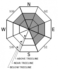
Slabs of wind drifted snow exist on leeward aspects in near and above treeline terrain. In some places, these wind slabs may still break away from the slope in response to the additional weight of a person on the slope. The largest and most sensitive wind slabs should exist on NW-N-NE-E-SE aspects along the Sierra Crest where more new snow accumulated. In areas where less new snow fell, wind slabs should remain smaller. Some wind slab avalanches could involve enough snow to bury or injure a person. Reports of a potential surface hoar layer in the Carson Pass area mean that some of these slabs may be more fragile there. 

Look for clues like blowing snow, cornices above a slope, drifted snow, wind created surface textures, recent wind slab avalanche activity, and cracking in drifted snow. These signs can help identify where wind slab problems exist. Use this information to create travel plans and safety margins that keep your party our of harm's way from these wind slab problems. 

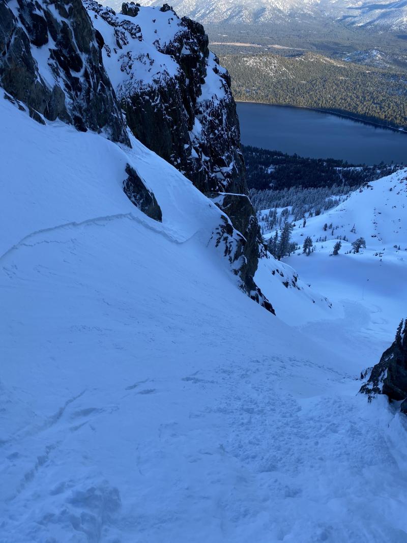
Ski cut triggered wind slab avalanche on Tallac from yesterday:

Avalanche Problem 2: Persistent Slab
  • Type ?
  • Aspect/Elevation ?
  • Likelihood ?
    Certain
    Very Likely
    Likely
    Possible
    Unlikely
  • Size ?
    Historic
    Very Large
    Large
    Small

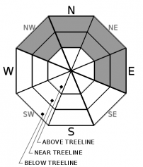
No avalanches have been reported on the Jan 4 persistent weak layer since last weekend. Despite the lack of activity snowpit tests continued to indicate weakness in this layer during the week. That data has become more variable over time with more tests producing stable results and fewer tests producing unstable results. We also did not see or receive any reports of avalanches failing on this layer during yesterday's rain/snow event that reloaded the snowpack. In general, the majority of data and observations indicate that avalanches on this layer have become unlikely on a regional scale. Some uncertainty still exists about this layer. It may not be impossible for the right trigger to find the right trigger spot or for a larger load to trigger this layer on an isolated slope. If that unlikely but not impossible scenario were to happen, the consequences would be quite serious.

Continue to pay attention to this layer even though avalanche activity is unlikely. Look for any signs of instability associated with it like shooting cracks and unstable snowpit tests. If you have any doubts about whether or not this layer is problematic, move to a different area.

recent observations

* A party intentionally triggered a small wind slab avalanche with a ski cut on a steep wind-loaded slope on Mt. Tallac yesterday. Skier-triggered and snowmobile-triggered cracking also occurred on smaller wind-loaded test slopes on the Sierra Crest and in the Mt Rose area. Observers reported blowing and drifting snow throughout the forecast area yesterday. 

* Observers on Round Top near Carson Pass reported unstable test results on what appeared to be an isolated buried surface hoar layer

* Snowmobilers near Webber Lake reported small loose wet sluffs on steep NE facing slopes at 7300 ft. Reports indicated that heavy wet snow existed at lower elevations along the Sierra Crest. 

* In areas where people targeted the Jan 4 weak layer snowpit tests mostly showed improvement with a few exceptions. Snowpit tests on a SE slope on Mt. Houghton produced unstable results. On Luther Pass tests on this layer mostly showed improvement with only 1 out of 5 tests indicating instability. Tests near Webber Lake, on Relay Peak, and on Tamarack Peak did not produce any unstable results.

Weather and CURRENT CONDITIONS
weather summary

After a rainy Saturday night, snow levels dropped to below 7000 ft yesterday and the storm ended up leaving about 4 to 6 inches of new snow on the Sierra Crest and about 2 to 3 inches in mountains on the east side of the Lake. Sensors and reposts indicated some areas north of Tahoe City got up to 8 to 10 inches of new snow. Winds started to decrease last night and cloud cover started to break up yesterday. Moderate SW winds should continue today and some cloud cover should remain as a weak disturbance moves through north of our region. Another weak system should move through on Tuesday with increased winds and a slight chance for some light flurries with no accumulation north of Hwy 50.

CONDITIONS ALONG THE SIERRA CREST BETWEEN 8200 FT. AND 9200 FT. IN THE LAST 24 HOURS
6am temperature: 23 to 28 deg. F.
Max. temperature: 29 to 33 deg. F.
Average ridgetop wind direction: SW
Average ridgetop wind speed: 27 to 34 mph
Maximum ridgetop wind gust: 74 mph
New snowfall: 1 to 8 inches
Total snow depth: 47 to 57 inches
Two-Day Mountain Weather Forecast Produced in partnership with the Reno NWS
For 7000 ft. to 8000 ft.
Monday Monday Night Tuesday
Weather: Mostly cloudy. Snow levels below 7000 feet. Chance of precipitation is 0%. Mostly cloudy. Snow levels below 7000 feet. Chance of precipitation is 0%. Partly cloudy then becoming mostly cloudy. Chance of snow showers in the afternoon. Snow levels below 7000 feet. Chance of precipitation is 25%.
Temperatures: 36 to 42 deg. F. 25 to 30 deg. F. 37 to 42 deg. F.
Mid Slope Winds: West 10 to 15 mph with gusts to 25 mph. Southwest around 15 mph with gusts to 35 mph. Southwest around 15 mph with gusts to 35 mph.
Expected snowfall: No accumulation. | SWE = none. No accumulation. | SWE = none. No accumulation. | SWE = trace amounts.
For 8000 ft. to 9000 ft.
Monday Monday Night Tuesday
Weather: Mostly cloudy. Snow levels below 7000 feet. Chance of precipitation is 0%. Mostly cloudy. Snow levels below 7000 feet. Chance of precipitation is 0%. Partly cloudy then becoming mostly cloudy. Chance of snow showers in the afternoon. Snow levels below 7000 feet. Chance of precipitation is 25%.
Temperatures: 29 to 37 deg. F. 23 to 28 deg. F. 32 to 38 deg. F.
Ridge Top Winds: West 15 to 30 mph. Gusts up to 45 mph. Southwest 15 to 30 mph. Gusts up to 55 mph. Southwest 25 to 40 mph with gusts to 65 mph.
Expected snowfall: No accumulation. | SWE = none. No accumulation. | SWE = none. No accumulation. | SWE = trace amounts.
Disclaimer

This avalanche forecast is provided through a partnership between the Tahoe National Forest and the Sierra Avalanche Center. This forecast covers the Central Sierra Nevada Mountains between Yuba Pass on the north and Ebbetts Pass on the south. Click here for a map of the forecast area. This forecast applies only to backcountry areas outside established ski area boundaries. This forecast describes general avalanche conditions and local variations always occur. This forecast expires 24 hours after the posted time unless otherwise noted. The information in this forecast is provided by the USDA Forest Service who is solely responsible for its content.

For a recorded version of the avalanche forecast call (530) 587-3558 x258