THIS AVALANCHE FORECAST EXPIRED ON January 4, 2020 @ 6:59 am
Avalanche Forecast published on January 3, 2020 @ 6:59 am
Issued by Brandon Schwartz - Tahoe National Forest

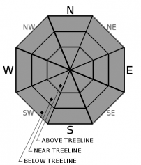
On a regional scale, LOW avalanche danger exists for all elevations. An isolated unstable area may be out there in the form of wind drifted snow or warming wet snow. However unlikely it is to trigger an avalanche today on a regional scale, today is not a no danger scenario.

1. Low

?

Above Treeline
Generally safe avalanche conditions. Watch for unstable snow on isolated terrain features.

1. Low

?

Near Treeline
Generally safe avalanche conditions. Watch for unstable snow on isolated terrain features.

1. Low

?

Below Treeline
Generally safe avalanche conditions. Watch for unstable snow on isolated terrain features.
    Generally safe avalanche conditions. Watch for unstable snow on isolated terrain features.
Avalanche Problem 1: Normal Caution
  • Type ?
  • Aspect/Elevation ?
  • Likelihood ?
    Certain
    Very Likely
    Likely
    Possible
    Unlikely
  • Size ?
    Historic
    Very Large
    Large
    Small

No avalanches have been reported in the past week. There have been ongoing moderate to gale force wind events, shifting winds, and light to moderate amounts of blowing snow for many days now. For the most part, the snow available to drift and deposit as unstable wind slabs is extremely limited, especially where capped by rain crust below 9,000'. If you encounter a smooth looking, not icy area near treeline or above treeline, you may have found the isolated, potentially unstable wind slab. Move around it with caution.

While some warming and snow surface melt is expected today on southerly aspects, the expected amount of wet snow formation is unlikely to create much in the way of a loose wet avalanche problem. Expect more warming and wet snow formation around exposed rocks. If you encounter a few inches or more of surface wet snow, manage for a loose wet avalanche problem.

The challenge with isolated instability is that when encountering slope after slope of stable snow, our human brains get lazy, turn off, and we let down our guard. During periods of LOW danger, travel avalanche terrain using the tactics of Normal Caution, just as if the danger rating were higher in order to minimize exposure and consequences from an unexpected human triggered avalanche. If venturing into couloirs, cliff areas, or other complex terrain where snowpack variability is usually greater, expect a greater likelihood of finding that isolated area of unstable snow.

recent observations

* Generally stable snowpack conditions have been reported throughout the forecast area.

* Periods of blowing snow have been ongoing for over a week from moderate to gale force NE to E and SW to W ridgetop winds. Minimal new wind slab formation has occurred in recent days.

* Rain to about 9,000' on Jan 1 left behind a breakable to supportable crust on all aspects. Long sliding falls could occur in areas where this crust is firm.

Weather and CURRENT CONDITIONS
weather summary

Ridgetop winds remain moderate in speed out of the NE early this morning. As the day progresses, winds are forecast to decrease and shift to the S to SW as a weak weather system approaches. Wind speeds are expected to increase to the moderate to strong range tonight through Saturday morning. Well above freezing air temperatures are expected today with 40s forecast for most locations in the 7,000' to 9,000' range. Expect a mix of sun and high level cloud cover today. There is a slight chance of snowfall tomorrow morning with a trace to an inch of accumulation possible. Clearing skies are forecast for tomorrow afternoon.

CONDITIONS ALONG THE SIERRA CREST BETWEEN 8200 FT. AND 9200 FT. IN THE LAST 24 HOURS
6am temperature: 32 to 38 deg. F.
Max. temperature: 36 to 41 deg. F.
Average ridgetop wind direction: NE
Average ridgetop wind speed: 39 mph
Maximum ridgetop wind gust: 76 mph
New snowfall: 0 inches
Total snow depth: 43 to 46 inches
Two-Day Mountain Weather Forecast Produced in partnership with the Reno NWS
For 7000 ft. to 8000 ft.
Friday Friday Night Saturday
Weather: Mostly cloudy. Snow levels below 7000 feet increasing to 7000 feet in the afternoon. Chance of precipitation is 0%. Partly cloudy. Snow levels below 7000 feet. Chance of precipitation is 0%. Partly cloudy. Slight chance of snow in the morning. Snow levels below 7000 feet. Chance of precipitation is 15%.
Temperatures: 44 to 49. deg. F. 27 to 32. deg. F. 39 to 44. deg. F.
Mid Slope Winds: Light winds becoming southwest around 15 mph with gusts to 35 mph in the afternoon. Southwest 15 to 30 mph. Gusts up to 45 mph increasing to 55 mph after midnight. Southwest 15 to 30 mph. Gusts up to 55 mph decreasing to 45 mph in the afternoon.
Expected snowfall: No accumulation. | SWE = none. No accumulation. | SWE = none. Up to 1 inch. | SWE = less than 0.10 inch.
For 8000 ft. to 9000 ft.
Friday Friday Night Saturday
Weather: Mostly cloudy. Snow levels below 7000 feet increasing to 7500 feet in the afternoon. Chance of precipitation is 0%. Partly cloudy. Snow levels below 7000 feet. Chance of precipitation is 0%. Partly cloudy then becoming sunny. Slight chance of snow in the morning. Snow levels below 7000 feet. Chance of precipitation is 15%.
Temperatures: 41 to 46. deg. F. 24 to 29. deg. F. 36 to 41. deg. F.
Ridge Top Winds: South 15 to 25 mph. Gusts up to 40 mph in the afternoon. Southwest 25 to 35 mph increasing to 30 to 50 mph after midnight. Gusts up to 80 mph. Southwest 30 to 45 mph with gusts to 75 mph decreasing to 20 to 30 mph with gusts to 50 mph in the afternoon.
Expected snowfall: No accumulation. | SWE = none. No accumulation. | SWE = none. Up to 1 inch. | SWE = less than 0.10 inch.
Disclaimer

This avalanche forecast is provided through a partnership between the Tahoe National Forest and the Sierra Avalanche Center. This forecast covers the Central Sierra Nevada Mountains between Yuba Pass on the north and Ebbetts Pass on the south. Click here for a map of the forecast area. This forecast applies only to backcountry areas outside established ski area boundaries. This forecast describes general avalanche conditions and local variations always occur. This forecast expires 24 hours after the posted time unless otherwise noted. The information in this forecast is provided by the USDA Forest Service who is solely responsible for its content.

For a recorded version of the avalanche forecast call (530) 587-3558 x258