THIS AVALANCHE FORECAST EXPIRED ON February 1, 2020 @ 6:47 am
Avalanche Forecast published on January 31, 2020 @ 6:47 am
Issued by Brandon Schwartz - Tahoe National Forest

Snow surface melt leading to loose wet avalanche problems is expected today at all elevations, mainly in areas of direct sun exposure. Most avalanches will be fairly small, but avalanches large enough to bury a person could occur. MODERATE avalanche danger exists at all elevations.

2. Moderate

?

Above Treeline
Heightened avalanche conditions on specific terrain features. Evaluate snow and terrain carefully; identify features of concern.

2. Moderate

?

Near Treeline
Heightened avalanche conditions on specific terrain features. Evaluate snow and terrain carefully; identify features of concern.

2. Moderate

?

Below Treeline
Heightened avalanche conditions on specific terrain features. Evaluate snow and terrain carefully; identify features of concern.
    Heightened avalanche conditions on specific terrain features. Evaluate snow and terrain carefully; identify features of concern.
Avalanche Problem 1: Loose Wet
  • Type ?
  • Aspect/Elevation ?
  • Likelihood ?
    Certain
    Very Likely
    Likely
    Possible
    Unlikely
  • Size ?
    Historic
    Very Large
    Large
    Small

Snow surface refreeze is expected to have occurred last night due to radiational cooling under mostly clear skies despite above freezing air temperatures. These same mostly clear skies and well above freezing air temperatures at sunrise today will allow snow surface melt to occur quickly on E-SE-S-SW-W aspects. Fairly widespread loose wet avalanche problems are expected today with avalanche size mostly at D1 with up to D2 possible. The still fairly low sun angle and shorter length of daylight hours this time of year are expected to keep problematic amounts of surface wet snow from forming today on NW-N-NE aspects.

Areas around exposed rocks in direct sun is where the greatest amount of incoming solar radiation and snow surface heating will occur. Rollerballs are an indication that instability associated with loose wet avalanches is forming. Choose terrain wisely considering how consequences from otherwise small avalanches can be greatly exacerbated by involvement with trees, rocks, cliffs or terrain traps below.

  Photo: Intentionally triggered size D1 loose wet avalanche yesterday following an unforecast light rain event. Details below.

recent observations

* An unforecast light rain event early yesterday morning brought 0.1 to 0.3 inches of liquid water to areas extending from the northern boundary of the forecast area down to around Carson Pass.

* In areas that received light rain, the top half to 1 inch of the snowpack was wet yesterday on all aspects up to at least 8,800'. This is expected to have refrozen as surface crust last night.

* A small size D1 loose wet avalanche was intentionally skier triggered yesterday on the lower northern flanks of Donner Peak (Donner Summit area) on a NW aspect at around 7000' on a 35-40 degree slope.

Weather and CURRENT CONDITIONS
weather summary

High pressure and sunny skies will be over the forecast area today and tomorrow. Air temperature inversion conditions are in place this morning with the coldest air down on the mountain valley floors and well above freezing air temperatures overnight at the mid and upper elevations. Maximum daytime air temperatures today and tomorrow will climb well above freezing at all elevations. Ridgetop winds out of the NE are forecast to shift to the SW by this afternoon with light to moderate wind speeds expected. Ridgetop winds will begin to increase Saturday afternoon, reaching gale force Saturday night. A strong cold front will move through the region on Sunday bringing dramatic air temperature cooling and a short period of high intensity snowfall.

CONDITIONS ALONG THE SIERRA CREST BETWEEN 8200 FT. AND 9200 FT. IN THE LAST 24 HOURS
6am temperature: 38 to 42 deg. F.
Max. temperature: 42 to 46 deg. F.
Average ridgetop wind direction: NE
Average ridgetop wind speed: 26 mph
Maximum ridgetop wind gust: 49 mph
New snowfall: 0 inches
Total snow depth: 45 to 52 inches
Two-Day Mountain Weather Forecast Produced in partnership with the Reno NWS
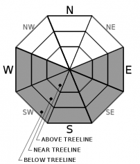
For 7000 ft. to 8000 ft.
Friday Friday Night Saturday
Weather: Sunny. Snow levels 8000 feet. Chance of precipitation is 0%. Clear. Snow levels 8000 feet. Chance of precipitation is 0%. Sunny. Snow levels 7000 feet increasing to 8000 feet in the afternoon. Chance of precipitation is 0%.
Temperatures: 49 to 55. deg. F. 30 to 35. deg. F. 51 to 57. deg. F.
Mid Slope Winds: Light winds. Light winds. Light winds becoming southwest around 15 mph with gusts to 30 mph in the afternoon.
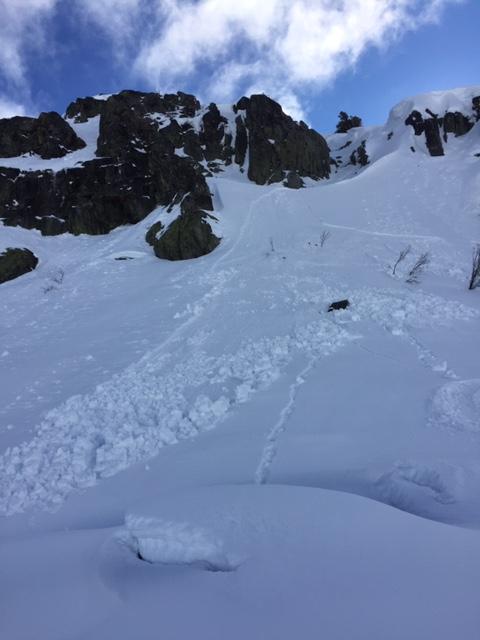
Expected snowfall: No accumulation. | SWE = none. No accumulation. | SWE = none. No accumulation. | SWE = none.
For 8000 ft. to 9000 ft.
Friday Friday Night Saturday
Weather: Sunny. Snow levels 8000 feet. Chance of precipitation is 0%. Clear. Snow levels 8000 feet. Chance of precipitation is 0%. Sunny. Snow levels 7000 feet increasing to 8000 feet in the afternoon. Chance of precipitation is 0%.
Temperatures: 47 to 53. deg. F. 33 to 38. deg. F. 47 to 53. deg. F.
Ridge Top Winds: Northwest around 15 mph shifting to the southeast in the afternoon. Gusts up to 30 mph. Southwest around 15 mph. Gusts up to 25 mph in the evening. Southwest 15 to 25 mph. Gusts up to 25 mph increasing to 40 mph in the afternoon.
Expected snowfall: No accumulation. | SWE = none. No accumulation. | SWE = none. No accumulation. | SWE = none.
Disclaimer

This avalanche forecast is provided through a partnership between the Tahoe National Forest and the Sierra Avalanche Center. This forecast covers the Central Sierra Nevada Mountains between Yuba Pass on the north and Ebbetts Pass on the south. Click here for a map of the forecast area. This forecast applies only to backcountry areas outside established ski area boundaries. This forecast describes general avalanche conditions and local variations always occur. This forecast expires 24 hours after the posted time unless otherwise noted. The information in this forecast is provided by the USDA Forest Service who is solely responsible for its content.

For a recorded version of the avalanche forecast call (530) 587-3558 x258