THIS AVALANCHE FORECAST EXPIRED ON January 5, 2020 @ 7:00 am
Avalanche Forecast published on January 4, 2020 @ 7:00 am
Issued by Brandon Schwartz - Tahoe National Forest

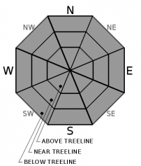
On a regional scale, LOW avalanche danger exists for all elevations. Small, isolated areas of unstable snow from either wind drifted slabs or warming wet snow may or may not exist today. Don't let the danger rating lull you into complacency.

1. Low

?

Above Treeline
Generally safe avalanche conditions. Watch for unstable snow on isolated terrain features.

1. Low

?

Near Treeline
Generally safe avalanche conditions. Watch for unstable snow on isolated terrain features.

1. Low

?

Below Treeline
Generally safe avalanche conditions. Watch for unstable snow on isolated terrain features.
    Generally safe avalanche conditions. Watch for unstable snow on isolated terrain features.
Avalanche Problem 1: Normal Caution
  • Type ?
  • Aspect/Elevation ?
  • Likelihood ?
    Certain
    Very Likely
    Likely
    Possible
    Unlikely
  • Size ?
    Historic
    Very Large
    Large
    Small

Small, isolated unstable wind slabs are unlikely but not impossible today in near treeline and above treeline terrain. If you encounter a smooth looking, not icy area near treeline or above treeline, you may have found the isolated, potentially unstable wind slab. Express some uncertainty and move around it with caution.

Another round of warming and snow surface melt is expected today on southerly aspects. The expected amount of wet snow formation is unlikely to create much in the way of a loose wet avalanche problem. Expect more warming and wet snow formation around exposed rocks, especially if wind protected. If you encounter a few inches or more of surface wet snow, manage for a loose wet avalanche problem.

If venturing into couloirs, cliff areas, or other complex terrain where snowpack variability is usually greater, expect a greater likelihood of finding that isolated area of unstable snow. In this type of terrain, expect that the consequences of an otherwise tiny and inconsequential avalanche will be magnified by the rocks and cliffs below you. Today's danger rating is the call to lull your brain into complacency. Avoid that by using the tactics of Normal Caution while in or below avalanche terrain, just as if the danger rating were higher in order to minimize exposure and consequences from an unexpected human triggered avalanche.

recent observations

* No avalanches have been reported for over a week. Generally stable snowpack conditions have been reported throughout the forecast area.

* Periods of blowing snow have been ongoing for over a week from moderate to gale force NE to E and SW to W ridgetop winds. For the most part, the snow available to drift and deposit as unstable wind slabs is extremely limited, especially where capped by rain crust below 9,000'. Minimal new wind slab formation has occurred in recent days.

* Rain to about 9,000' on Jan 1 left behind a breakable to supportable crust on all aspects. Melt-freeze on SE-S-SW aspects over the past two days has thickened this crust.

Weather and CURRENT CONDITIONS
weather summary

A few snowflakes fell this morning from north of Yuba Pass down to Echo Summit in a brief trace accumulation snowfall event. Ridgetop winds out of the SW remain strong but have decreased from the overnight peak at gale force. Wind speed is forecast to further decrease to the moderate range as the day progresses. Following this morning's brief snowfall event, cloud cover is expected to clear and then become partly cloudy this afternoon. Air temperatures are expected to warm above freezing again today, but not as warm as yesterday and with more wind than yesterday. A cooler day with sunny skies and moderate winds is forecast for tomorrow.

CONDITIONS ALONG THE SIERRA CREST BETWEEN 8200 FT. AND 9200 FT. IN THE LAST 24 HOURS
6am temperature: 25 to 28 deg. F.
Max. temperature: 44 to 51 deg. F.
Average ridgetop wind direction: SW
Average ridgetop wind speed: 40 mph
Maximum ridgetop wind gust: 96 mph
New snowfall: 0 to trace inches
Total snow depth: 42 to 46 inches
Two-Day Mountain Weather Forecast Produced in partnership with the Reno NWS
For 7000 ft. to 8000 ft.
Saturday Saturday Night Sunday
Weather: Sunny then becoming partly cloudy. Slight chance of snow in the morning. Snow levels below 7000 feet. Chance of precipitation is 10%. Partly cloudy. Snow levels below 7000 feet. Chance of precipitation is 5%. Sunny. Snow levels below 7000 feet. Chance of precipitation is 5%.
Temperatures: 40 to 45. deg. F. 20 to 25. deg. F. 32 to 37. deg. F.
Mid Slope Winds: Southwest 15 to 30 mph with gusts to 55 mph. Southwest 15 to 20 mph. Gusts up to 25 mph increasing to 40 mph after midnight. West 15 to 25 mph with gusts to 35 mph.
Expected snowfall: No accumulation. | SWE = trace amounts. No accumulation. | SWE = none. No accumulation. | SWE = none.
For 8000 ft. to 9000 ft.
Saturday Saturday Night Sunday
Weather: Sunny then becoming partly cloudy. Slight chance of snow in the morning. Snow levels below 7000 feet. Chance of precipitation is 10%. Partly cloudy. Snow levels below 7000 feet. Chance of precipitation is 5%. Partly cloudy then becoming sunny. Snow levels below 7000 feet. Chance of precipitation is 5%.
Temperatures: 37 to 42. deg. F. 17 to 22. deg. F. 28 to 33. deg. F.
Ridge Top Winds: Southwest 30 to 45 mph with gusts to 80 mph decreasing to 20 to 30 mph with gusts to 55 mph in the afternoon. Southwest 15 to 30 mph. Gusts up to 35 mph increasing to 45 mph after midnight. West 15 to 30 mph. Gusts up to 50 mph decreasing to 40 mph in the afternoon.
Expected snowfall: No accumulation. | SWE = trace amounts. No accumulation. | SWE = none. No accumulation. | SWE = none.
Disclaimer

This avalanche forecast is provided through a partnership between the Tahoe National Forest and the Sierra Avalanche Center. This forecast covers the Central Sierra Nevada Mountains between Yuba Pass on the north and Ebbetts Pass on the south. Click here for a map of the forecast area. This forecast applies only to backcountry areas outside established ski area boundaries. This forecast describes general avalanche conditions and local variations always occur. This forecast expires 24 hours after the posted time unless otherwise noted. The information in this forecast is provided by the USDA Forest Service who is solely responsible for its content.

For a recorded version of the avalanche forecast call (530) 587-3558 x258