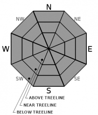
THIS AVALANCHE FORECAST EXPIRED ON January 6, 2020 @ 6:57 am
Avalanche Forecast published on January 5, 2020 @ 6:57 am
Issued by Andy Anderson - Tahoe National Forest - Sierra Avalanche Center

Triggering an avalanche remains unlikely on a regional scale. LOW avalanche danger does not mean no avalanche danger. Some areas of unstable wind drifted snow or cornices may still linger on isolated terrain features especially in complex or extreme terrain. Focus on using safe travel techniques, maintaining awareness, and having open discussions with your partners to avoid getting complacent.

1. Low

?

Above Treeline
Generally safe avalanche conditions. Watch for unstable snow on isolated terrain features.

1. Low

?

Near Treeline
Generally safe avalanche conditions. Watch for unstable snow on isolated terrain features.

1. Low

?

Below Treeline
Generally safe avalanche conditions. Watch for unstable snow on isolated terrain features.
    Generally safe avalanche conditions. Watch for unstable snow on isolated terrain features.
Avalanche Problem 1: Normal Caution
  • Type ?
  • Aspect/Elevation ?
  • Likelihood ?
    Certain
    Very Likely
    Likely
    Possible
    Unlikely
  • Size ?
    Historic
    Very Large
    Large
    Small

In most of the forecast area, triggering an avalanche has become unlikely. Unlikely does not mean impossible. An unstable slab of wind drifted snow or a fragile cornice may still linger on an isolated terrain feature. These small and isolated instabilities could still have consequences especially in the more complex and challenging terrain that many people chose on LOW danger days. That complex terrain (cliffy areas, couloirs, etc) also has more variability and will be more likely to hold one of those isolated areas of instability.

While more terrain may open up on LOW danger days, continue to minimize exposure by traveling with normal caution. Only expose one person at a time to a slope, watch your partners as they move through avalanche terrain, and regroup in safe areas out of avalanche paths. Continue to evaluate slopes for stability and snow conditions before committing to them. Pausing to discuss whether or not it makes sense to commit to the slope in front of you can help fight the complacency that often accompanies a LOW danger day. 

recent observations

* Yesterday observations from Lincoln Ridge found small but fragile cornices along some ridgelines with small and unreactive wind slabs on wind loaded slopes. 1-1.5 inches of new snow accumulated there during the morning. 

* Farther south on Waterhouse Peak only a trace of new snow existed and no signs of instability were observed. 

* No avalanches have been reported for over a week. Generally, stable snowpack conditions have been reported throughout the forecast area.

* Variable snow surface conditions ranging from scoured icy crusts, sastrugi, and other wind affected textures exist on exposed near and above treeline terrain. In more sheltered areas, thin rain crusts and softer snow exist. 

Weather and CURRENT CONDITIONS
weather summary

A quick burst of snow left up to an inch of new snow in some places along the Sierra Crest north of Tahoe City yesterday morning. Strong winds impacted the entire forecast area yesterday morning. Then the sun came out and the winds started to decrease. Another weak storm system passing to the north of the region lead the SW winds to increase a bit overnight. Cloud cover and winds should decrease more today as mostly sunny cool weather moves into the region through Tuesday.

CONDITIONS ALONG THE SIERRA CREST BETWEEN 8200 FT. AND 9200 FT. IN THE LAST 24 HOURS
6am temperature: 19 to 27 deg. F.
Max. temperature: 31 to 43 deg. F.
Average ridgetop wind direction: SW
Average ridgetop wind speed: 25 to 33 mph
Maximum ridgetop wind gust: 74 mph
New snowfall: Trace with some areas N of Tahoe City reporting up to 1 inches
Total snow depth: 42 to 45 inches
Two-Day Mountain Weather Forecast Produced in partnership with the Reno NWS
For 7000 ft. to 8000 ft.
Sunday Sunday Night Monday
Weather: Partly cloudy then becoming sunny. Snow levels below 7000 feet. Chance of precipitation is 5%. Clear. Snow levels below 7000 feet. Chance of precipitation is 0%. Sunny. Snow levels below 7000 feet. Chance of precipitation is 0%.
Temperatures: 33 to 38 deg. F. 13 to 18 deg. F. 37 to 42 deg. F.
Mid Slope Winds: West 15 to 20 mph with gusts to 35 mph. Light winds. Light winds.
Expected snowfall: No accumulation. | SWE = none. No accumulation. | SWE = none. No accumulation. | SWE = none.
For 8000 ft. to 9000 ft.
Sunday Sunday Night Monday
Weather: Partly cloudy then becoming sunny. Snow levels below 7000 feet. Chance of precipitation is 5%. Clear. Snow levels below 7000 feet. Chance of precipitation is 0%. Sunny. Snow levels below 7000 feet. Chance of precipitation is 0%.
Temperatures: 30 to 35 deg. F. 13 to 18 deg. F. 34 to 39 deg. F.
Ridge Top Winds: West 15 to 30 mph with gusts to 45 mph. Northwest 15 to 20 mph shifting to the east after midnight. Gusts up to 30 mph. Southeast around 15 mph.
Expected snowfall: No accumulation. | SWE = none. No accumulation. | SWE = none. No accumulation. | SWE = none.
Disclaimer

This avalanche forecast is provided through a partnership between the Tahoe National Forest and the Sierra Avalanche Center. This forecast covers the Central Sierra Nevada Mountains between Yuba Pass on the north and Ebbetts Pass on the south. Click here for a map of the forecast area. This forecast applies only to backcountry areas outside established ski area boundaries. This forecast describes general avalanche conditions and local variations always occur. This forecast expires 24 hours after the posted time unless otherwise noted. The information in this forecast is provided by the USDA Forest Service who is solely responsible for its content.

For a recorded version of the avalanche forecast call (530) 587-3558 x258