THIS AVALANCHE FORECAST EXPIRED ON January 8, 2020 @ 6:58 am
Avalanche Forecast published on January 7, 2020 @ 6:58 am
Issued by Steve Reynaud - Tahoe National Forest

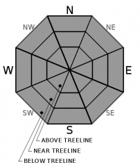
Avalanches continue to be unlikely throughout the forecast area, LOW avalanche danger exists at all elevations.  Normal caution is advised when traveling in the backcountry.  A more active weather pattern is forecasted to start late tonight with increasing chances of snow into the weekend. 

1. Low

?

Above Treeline
Generally safe avalanche conditions. Watch for unstable snow on isolated terrain features.

1. Low

?

Near Treeline
Generally safe avalanche conditions. Watch for unstable snow on isolated terrain features.

1. Low

?

Below Treeline
Generally safe avalanche conditions. Watch for unstable snow on isolated terrain features.
    Generally safe avalanche conditions. Watch for unstable snow on isolated terrain features.
Avalanche Problem 1: Normal Caution
  • Type ?
  • Aspect/Elevation ?
  • Likelihood ?
    Certain
    Very Likely
    Likely
    Possible
    Unlikely
  • Size ?
    Historic
    Very Large
    Large
    Small

Avalanches remain unlikely throughout the forecast region.  Winds will increase today ahead of a weak storm that is forecasted to bring 2-3'' of new snow along the Sierra Crest late tonight into Wednesday morning.  With limited to no snow available for wind transport today, strong SW winds this afternoon and evening are expected to move only limited amounts of existing snow.  A variety of crusts, firm surfaces, windblown snow, and some spring snow exist out in the backcountry. 

Warm temperatures and full sunshine should allow the snow surface to soften on southerly aspects today and provide soft spring snow conditions.  Increasing strong SW winds this afternoon could limit some of the snow surface warming at the higher elevations and wind exposed terrain.  Loose wet avalanche activity is expected to be small and in the form of roller balls and pinwheels.  Terrain traps such as steep creek beds, cliffs, rocks, and trees could increase the consequences of even a small amount of sliding snow.

Normal caution is advised.  Carry avalanche rescue equipment: transceiver, probe, and shovel.  Focus on safe travel techniques.  Continue to look for unstable snow and potential hazards.  Have open communication within your group.  Regroup in safe areas out of avalanche paths.  And debrief the day with your group. 

recent observations

Soft spring snow was found on Rose Knob ( Mt. Rose area) yesterday in the late morning hours.  Supportive snow conditions were found above 8000' with some deeper and softer snow at the lower elevations.  Variable crusts existed on shaded northerly aspects.

On Castle Peak ( Donner Summit area) windblown snow on crust conditions were present on northerly aspects.  Large faceted grains were found underneath the Jan 4 rain crust in some areas.  Southerly aspects provided supportable spring snow into the early afternoon.

Surface hoar has been reported in some areas over the last few days.  This will be important today as any existing surface hoar could be buried tonight with a few inches of new snow.  Let us know if you see any surface hoar in your area today!

Weather and CURRENT CONDITIONS
weather summary

Another sunny and dry day is forecasted today with temperatures 5 to 10 degrees above normal.  SW winds will be increasing through today to strong to gale force at the upper elevations by this evening.  Late tonight into early Wednesday morning a weak storm could potentially drop 2 to 3'' of snow along the Sierra Crest with 1 to 2'' at Lake level.  Another weak system Wednesday night into Thursday could produce slightly higher snow totals with less wind.  The active weather pattern could continue through the weekend with cooling temperatures. 

CONDITIONS ALONG THE SIERRA CREST BETWEEN 8200 FT. AND 9200 FT. IN THE LAST 24 HOURS
6am temperature: 28 to 38 deg. F.
Max. temperature: 40 to 47 deg. F.
Average ridgetop wind direction: NE to SW
Average ridgetop wind speed: 15 to 25 mph
Maximum ridgetop wind gust: 34 mph
New snowfall: 0 inches
Total snow depth: 42 to 45 inches
Two-Day Mountain Weather Forecast Produced in partnership with the Reno NWS
For 7000 ft. to 8000 ft.
Tuesday Tuesday Night Wednesday
Weather: Sunny then becoming partly cloudy. Snow levels below 7000 feet. Chance of precipitation is 0%. Clear then becoming mostly cloudy. Chance of snow through the night. Snow levels below 7000 feet. Chance of precipitation is 45%. Mostly cloudy then becoming partly cloudy. Slight chance of snow showers in the morning. Snow levels below 7000 feet. Chance of precipitation is 10%.
Temperatures: 40 to 45. deg. F. 18 to 23. deg. F. 30 to 35. deg. F.
Mid Slope Winds: Southwest around 15 mph. Gusts up to 25 mph increasing to 40 mph in the afternoon. Southwest 15 to 25 mph with gusts to 50 mph. Southwest around 15 mph. Gusts up to 35 mph decreasing to 25 mph in the afternoon.
Expected snowfall: No accumulation. | SWE = none. 90% probability up to 2 inches. 10% probability of 2 to 3 inches. | SWE = up to 0.15 inch. No accumulation. | SWE = trace amounts.
For 8000 ft. to 9000 ft.
Tuesday Tuesday Night Wednesday
Weather: Sunny then becoming partly cloudy. Snow levels below 7000 feet. Chance of precipitation is 0%. Clear then becoming mostly cloudy. Chance of snow through the night. Snow levels below 7000 feet. Chance of precipitation is 50%. Mostly cloudy then becoming partly cloudy. Slight chance of snow showers in the morning. Snow levels below 7000 feet. Chance of precipitation is 10%.
Temperatures: 37 to 42. deg. F. 15 to 20. deg. F. 25 to 30. deg. F.
Ridge Top Winds: Southwest around 15 mph with gusts to 30 mph increasing to 20 to 30 mph with gusts to 60 mph in the afternoon. Southwest 25 to 45 mph with gusts to 75 mph. West 15 to 25 mph. Gusts up to 45 mph decreasing to 30 mph in the afternoon.
Expected snowfall: No accumulation. | SWE = none. 80% probability up to 2 inches. 20% probability of 2 to 4 inches. | SWE = up to 0.15 inch. No accumulation. | SWE = trace amounts.
Disclaimer

This avalanche forecast is provided through a partnership between the Tahoe National Forest and the Sierra Avalanche Center. This forecast covers the Central Sierra Nevada Mountains between Yuba Pass on the north and Ebbetts Pass on the south. Click here for a map of the forecast area. This forecast applies only to backcountry areas outside established ski area boundaries. This forecast describes general avalanche conditions and local variations always occur. This forecast expires 24 hours after the posted time unless otherwise noted. The information in this forecast is provided by the USDA Forest Service who is solely responsible for its content.

For a recorded version of the avalanche forecast call (530) 587-3558 x258