THIS AVALANCHE FORECAST EXPIRED ON January 9, 2020 @ 7:00 am
Avalanche Forecast published on January 8, 2020 @ 7:00 am
Issued by Steve Reynaud - Tahoe National Forest

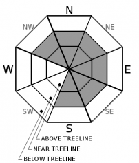
New snow with high winds has made wind slab avalanches possible in near and above treeline areas.  LOW avalanche danger will continue in below treeline terrain.  Active weather is forecasted to continue for our area.

2. Moderate

?

Above Treeline
Heightened avalanche conditions on specific terrain features. Evaluate snow and terrain carefully; identify features of concern.

2. Moderate

?

Near Treeline
Heightened avalanche conditions on specific terrain features. Evaluate snow and terrain carefully; identify features of concern.

1. Low

?

Below Treeline
Generally safe avalanche conditions. Watch for unstable snow on isolated terrain features.
    Heightened avalanche conditions on specific terrain features. Evaluate snow and terrain carefully; identify features of concern.
Avalanche Problem 1: Wind Slab
  • Type ?
  • Aspect/Elevation ?
  • Likelihood ?
    Certain
    Very Likely
    Likely
    Possible
    Unlikely
  • Size ?
    Historic
    Very Large
    Large
    Small

Strong to gale force SW winds with new snow will allow wind slabs to form in near and above treeline areas.  With limited amounts of new snow, most of these wind slabs are expected to be small in size.  Winds today will slightly shift to the W and remain strong in speed.  These new wind slabs will be forming on a variety of snow surfaces from firm crusts to weak old snow.  Bonding may be limited at the old snow/new snow interface. 

Look for blowing snow, new cornice formation, and wind pillows.  Hand pits and small test slopes can give you information on how the new wind slabs are bonding to the old snow surface.  Small avalanches in complex terrain or with terrain traps below can still have increased consequences.    

recent observations

Observations were received yesterday from Meeks Ridge (West Shore area), Elephants Hump (Carson Pass area), and Red Lake Peak (Carson Pass area).  Snow surface conditions continue to show weak surface rain crusts and near surface facets in mid elevation areas.  These areas will be of concern as we start to load the snowpack with small snow storms over the next week.

Surface hoar has been reported in several areas over the last few days, but appears to be variable in distribution.  It was found yesterday in lower elevation open meadows, but not higher up in steeper terrain on Red Lake Peak. 

Weather and CURRENT CONDITIONS
weather summary

1 to 2'' of new snow fell overnight mainly along the Sierra Crest.  Strong to gale force SW winds increased yesterday afternoon and will continue through today slightly decreasing and shifting to the W.  Our next small storm will come late tonight and into Thursday morning.  This storm is slightly larger with up to 4'' of snow possible.  A brief break is expected on late Thursday and Friday.  Starting Friday night, periods of snow showers could extend into the middle of next week.  These storms will continue small, but may become larger snow producers into next week.  Below average temperatures are expected through this period with snow levels below 5000'.

CONDITIONS ALONG THE SIERRA CREST BETWEEN 8200 FT. AND 9200 FT. IN THE LAST 24 HOURS
6am temperature: 16 to 24 deg. F.
Max. temperature: 34 to 42 deg. F.
Average ridgetop wind direction: SW
Average ridgetop wind speed: 25 to 40 mph
Maximum ridgetop wind gust: 73 mph
New snowfall: 1 to 2 inches
Total snow depth: 43 to 45 inches
Two-Day Mountain Weather Forecast Produced in partnership with the Reno NWS
For 7000 ft. to 8000 ft.
Wednesday Wednesday Night Thursday
Weather: Mostly cloudy. Snow levels below 7000 feet. Chance of precipitation is 5%. Mostly cloudy. Chance of snow after midnight. Snow levels below 7000 feet. Chance of precipitation is 35%. Mostly cloudy. Snow in the morning, then chance of snow showers in the afternoon. Snow levels below 7000 feet. Chance of precipitation is 75%.
Temperatures: 30 to 36. deg. F. 16 to 22. deg. F. 27 to 32. deg. F.
Mid Slope Winds: West around 15 mph with gusts to 35 mph. Southwest around 15 mph with gusts to 35 mph. West 15 to 20 mph with gusts to 40 mph.
Expected snowfall: No accumulation. | SWE = none. 90% probability up to 1 inch. 10% probability of 1 to 3 inches. | SWE = less than 0.10 inch. 80% probability of 1 to 3 inches. 20% probability of 3 to 5 inches. | SWE = up to 0.15 inch.
For 8000 ft. to 9000 ft.
Wednesday Wednesday Night Thursday
Weather: Mostly cloudy. Snow levels below 7000 feet. Chance of precipitation is 5%. Mostly cloudy. Chance of snow after midnight. Snow levels below 7000 feet. Chance of precipitation is 35%. Mostly cloudy. Snow likely in the morning, then chance of snow showers in the afternoon. Snow levels below 7000 feet. Chance of precipitation is 75%.
Temperatures: 24 to 30. deg. F. 12 to 17. deg. F. 22 to 28. deg. F.
Ridge Top Winds: Southwest 15 to 30 mph with gusts to 50 mph shifting to the west 15 to 20 mph with gusts to 35 mph in the afternoon. Southwest 15 to 30 mph. Gusts up to 45 mph increasing to 55 mph after midnight. West 15 to 30 mph. Gusts up to 60 mph decreasing to 40 mph in the afternoon.
Expected snowfall: No accumulation. | SWE = none. 90% probability up to 1 inch. 10% probability of 1 to 3 inches. | SWE = less than 0.10 inch. 70% probability of 1 to 3 inches. 30% probability of 3 to 5 inches. | SWE = up to 0.20 inch.
Disclaimer

This avalanche forecast is provided through a partnership between the Tahoe National Forest and the Sierra Avalanche Center. This forecast covers the Central Sierra Nevada Mountains between Yuba Pass on the north and Ebbetts Pass on the south. Click here for a map of the forecast area. This forecast applies only to backcountry areas outside established ski area boundaries. This forecast describes general avalanche conditions and local variations always occur. This forecast expires 24 hours after the posted time unless otherwise noted. The information in this forecast is provided by the USDA Forest Service who is solely responsible for its content.

For a recorded version of the avalanche forecast call (530) 587-3558 x258