THIS AVALANCHE FORECAST EXPIRED ON January 10, 2020 @ 6:50 am
Avalanche Forecast published on January 9, 2020 @ 6:50 am
Issued by Brandon Schwartz - Tahoe National Forest

Anticipate encountering unstable slabs of wind drifted snow today in wind exposed areas near treeline and above treeline. MODERATE avalanche danger exists above treeline and near treeline with LOW avalanche danger below treeline.

2. Moderate

?

Above Treeline
Heightened avalanche conditions on specific terrain features. Evaluate snow and terrain carefully; identify features of concern.

2. Moderate

?

Near Treeline
Heightened avalanche conditions on specific terrain features. Evaluate snow and terrain carefully; identify features of concern.

1. Low

?

Below Treeline
Generally safe avalanche conditions. Watch for unstable snow on isolated terrain features.
    Heightened avalanche conditions on specific terrain features. Evaluate snow and terrain carefully; identify features of concern.
Avalanche Problem 1: Wind Slab
  • Type ?
  • Aspect/Elevation ?
  • Likelihood ?
    Certain
    Very Likely
    Likely
    Possible
    Unlikely
  • Size ?
    Historic
    Very Large
    Large
    Small

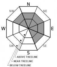
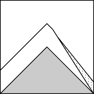
Small slabs of wind drifted snow that were easily triggered as size D1 wind slab avalanches yesterday are expected to remain unstable today. Additional snowfall with wind this morning will allow for more drifting and wind slab formation today. Anticipate encountering unstable wind slabs in wind exposed near treeline and above treeline terrain today, mainly on NW-N-NE-E-SE aspects. Expect avalanche size today mostly at D1 with size D2 possible in the most heavily wind drifted areas.

Identify where unstable wind slabs may exist and move around them with caution. Areas with pillows of wind drifted snow, slopes below cornices, and any smooth looking slopes in wind exposed areas are suspect. Human triggered snow surface cracking is a sign of unstable snow. Communicate what you see within your group. Listen to the concerns of others and include them in group decision making.

Avalanche Problem 2: Loose Dry
  • Type ?
  • Aspect/Elevation ?
  • Likelihood ?
    Certain
    Very Likely
    Likely
    Possible
    Unlikely
  • Size ?
    Historic
    Very Large
    Large
    Small

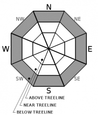
Small loose dry avalanches (sluffs) may occur today in steep wind protected areas below treeline. Recent new snow is low density and has been slow to bond to old snow surfaces. On a regional scale, this avalanche problem is unlikely today and limited only to areas that have accumulated a few inches or more of new snow yesterday and today. 

recent observations

* Small (size D1) wind slabs were easy to intentionally trigger yesterday in the Mt. Judah (Donner Summit) and Silver Peak (Pole Creek) areas. These small avalanches occurred in near treeline terrain on N-NE-E aspects where wind drifted snow had deposited. Crown size ranged from 4 to 8 inches. These areas had received about 2 inches of new snow.

* Further south in the Echo Summit area new snow was minimal at just 1 inch and did not allow for the formation of unstable wind slabs.

* There is faceted snow in the upper snowpack on NW-N-NE-E aspects, mainly around the thin Jan 4 rain crust and to a lesser extent around the thicker Dec 12 rain crust. Both of these layers are in a monitoring state with ongoing snowfall events in the weather forecast.

Weather and CURRENT CONDITIONS
weather summary

A weak weather system is moving through the area this morning. Light accumulating snowfall is expected this morning, tapering off this afternoon. Ridgetop winds out of the SW peaked last night and are down to moderate speed this morning. A shift from SW to W and eventually to NW is forecast today with continued moderate wind speed. A moderate to strong NE wind event is forecast for tonight. Winds are then expected to shift to the S tomorrow. The next weak weather system could bring additional light snow to the northern portion of the forecast area Friday night. Expect a chilly day today and a warmer day tomorrow.

CONDITIONS ALONG THE SIERRA CREST BETWEEN 8200 FT. AND 9200 FT. IN THE LAST 24 HOURS
6am temperature: 15 to 23 deg. F.
Max. temperature: 20 to 30 deg. F.
Average ridgetop wind direction: SW
Average ridgetop wind speed: 36 mph
Maximum ridgetop wind gust: 60 mph
New snowfall: Trace to 1 inches
Total snow depth: 41 to 45 inches
Two-Day Mountain Weather Forecast Produced in partnership with the Reno NWS
For 7000 ft. to 8000 ft.
Thursday Thursday Night Friday
Weather: Cloudy. Snow in the morning, then chance of snow in the afternoon. Snow levels below 7000 feet. Chance of precipitation is 90%. Clear. Snow levels below 7000 feet. Chance of precipitation is 0%. Sunny then becoming partly cloudy. Snow levels below 7000 feet. Chance of precipitation is 0%.
Temperatures: 28 to 33. deg. F. 14 to 20. deg. F. 37 to 42. deg. F.
Mid Slope Winds: West 15 to 20 mph. Gusts up to 45 mph decreasing to 35 mph in the afternoon. North around 15 mph in the evening becoming light. Gusts up to 30 mph. Light winds. Gusts up to 25 mph in the afternoon.
Expected snowfall: 80% probability of 1 to 2 inches. 20% probability of 2 to 4 inches. | SWE = up to 0.15 inch. No accumulation. | SWE = none. No accumulation. | SWE = none.
For 8000 ft. to 9000 ft.
Thursday Thursday Night Friday
Weather: Cloudy. Snow in the morning, then chance of snow in the afternoon. Snow levels below 7000 feet. Chance of precipitation is 90%. Clear. Snow levels below 7000 feet. Chance of precipitation is 0%. Sunny then becoming partly cloudy. Snow levels below 7000 feet. Chance of precipitation is 0%.
Temperatures: 23 to 28. deg. F. 12 to 17. deg. F. 33 to 39. deg. F.
Ridge Top Winds: Southwest 15 to 30 mph with gusts to 45 mph shifting to the northwest 15 to 20 mph with gusts to 35 mph in the afternoon. Northeast 20 to 30 mph with gusts to 60 mph. South 15 to 30 mph with gusts to 50 mph.
Expected snowfall: 90% probability of 1 to 3 inches. 10% probability of 3 to 5 inches. | SWE = up to 0.20 inch. No accumulation. | SWE = none. No accumulation. | SWE = none.
Disclaimer

This avalanche forecast is provided through a partnership between the Tahoe National Forest and the Sierra Avalanche Center. This forecast covers the Central Sierra Nevada Mountains between Yuba Pass on the north and Ebbetts Pass on the south. Click here for a map of the forecast area. This forecast applies only to backcountry areas outside established ski area boundaries. This forecast describes general avalanche conditions and local variations always occur. This forecast expires 24 hours after the posted time unless otherwise noted. The information in this forecast is provided by the USDA Forest Service who is solely responsible for its content.

For a recorded version of the avalanche forecast call (530) 587-3558 x258