THIS AVALANCHE FORECAST EXPIRED ON March 3, 2020 @ 6:59 am
Avalanche Forecast published on March 2, 2020 @ 6:59 am
Issued by Andy Anderson - Tahoe National Forest - Sierra Avalanche Center

Two main avalanche concerns exist for today: the fresh slabs of wind drifted snow deposited by the ENE winds and strong sunshine and warmer temperatures creating wet snow instabilities. Human triggered wind slabs and loose wet avalanches will be possible today. MODERATE avalanche danger exists at all elevations. 

2. Moderate

?

Above Treeline
Heightened avalanche conditions on specific terrain features. Evaluate snow and terrain carefully; identify features of concern.

2. Moderate

?

Near Treeline
Heightened avalanche conditions on specific terrain features. Evaluate snow and terrain carefully; identify features of concern.

2. Moderate

?

Below Treeline
Heightened avalanche conditions on specific terrain features. Evaluate snow and terrain carefully; identify features of concern.
    Heightened avalanche conditions on specific terrain features. Evaluate snow and terrain carefully; identify features of concern.
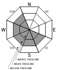
Avalanche Problem 1: Wind Slab
  • Type ?
  • Aspect/Elevation ?
  • Likelihood ?
    Certain
    Very Likely
    Likely
    Possible
    Unlikely
  • Size ?
    Historic
    Very Large
    Large
    Small

Gale force ENE winds have left scoured surfaces on windward (N-NE-E) aspects and fresh slabs of wind drifted snow on leeward (SE-S-SW-W-NW) aspects. These wind slabs could measure a few feet in depth and could involve enough snow to bury or injure a person. The weight of a person recreating on a wind-loaded slope could still trigger wind slab avalanches today. Strong sunshine and warmer temperatures may make some of these wind slabs more fragile especially on the sun-exposed SE-S-SW aspects

Identify where wind slabs may exist by using clues like cornices above a slope, drifted snow, and other wind created textures. These areas have the best chances for finding variable wind affected snow and unstable wind slabs. Lower angle more sheltered terrain will hold more consistent snow and present fewer avalanche hazards. 

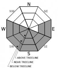
Avalanche Problem 2: Loose Wet
  • Type ?
  • Aspect/Elevation ?
  • Likelihood ?
    Certain
    Very Likely
    Likely
    Possible
    Unlikely
  • Size ?
    Historic
    Very Large
    Large
    Small

Strong March sunshine and a significant jump in air temperatures could produce enough warming to destabilize yesterday's cold light snow. Some wet snow instabilities will be possible today on sun-exposed slopes especially in areas sheltered from the strong ENE winds. While most of these wet snow instabilities may manifest as roller balls near exposed rocks or pinwheels on open slopes, some larger loose wet avalanches may be possible today. Expect more widespread loose wet activity as the warming trend continues for the next few days. 

Watch for signs of a warming snowpack like roller balls or pinwheels, dripping trees, or wet sticky surface snow. These signs indicate that rapid warming is affecting the snowpack and that it is time to move to a colder aspect

recent observations

* Yesterday skier triggered loose dry avalanches were reported on steep slopes on Andesite Peak. 

* A small ski cut triggered soft slab avalanche was also reported in the Deep Creek area. 

* Observations from Andesite Peak and the Elephants Back area showed strong winds, intense drifting snow, and long skier triggered shooting cracks on low angle wind-loaded slopes.

* On more sheltered slopes on Tamarack Peak and Andesite Peak, observers reported low density unconsolidated new snow resting on top of firm surfaces. In many places, the new snow barely covered exposed obstacles. 

Weather and CURRENT CONDITIONS
weather summary

Another 1 to 3 inches of snow accumulated yesterday bringing the storm totals for this storm to 6 to 15 inches of new snow. As the storm ended skies cleared and the E and NE wind increased in speed. Expect gale force ENE along the ridgetops today as a high-pressure ridge starts to build over the region. These winds should start to decrease this afternoon and evening. The temperature should also start to climb with today's highs about 10 degrees warmer than yesterday's. The forecast calls for another 10 ish degrees of warming tomorrow. This warming trend should continue through Friday. 

CONDITIONS ALONG THE SIERRA CREST BETWEEN 8200 FT. AND 9200 FT. IN THE LAST 24 HOURS
6am temperature: 9 to 15 deg. F.
Max. temperature: 17 to 24 deg. F.
Average ridgetop wind direction: ENE
Average ridgetop wind speed: 40 to 65 mph
Maximum ridgetop wind gust: 126 mph
New snowfall: 1 to 3 inches
Total snow depth: 43 to 54 inches
Two-Day Mountain Weather Forecast Produced in partnership with the Reno NWS
For 7000 ft. to 8000 ft.
Monday Monday Night Tuesday
Weather: Sunny. Chance of precipitation is 0%. Clear. Chance of precipitation is 0%. Sunny. Chance of precipitation is 0%.
Temperatures: 32 to 38 deg. F. 18 to 24 deg. F. 42 to 48 deg. F.
Mid Slope Winds: East 15 to 20 mph with gusts to 50 mph. Northeast around 15 mph in the evening becoming light. Gusts up to 30 mph. Light winds.
Expected snowfall: No accumulation. | SWE = none. No accumulation. | SWE = none. No accumulation. | SWE = none.
For 8000 ft. to 9000 ft.
Monday Monday Night Tuesday
Weather: Sunny. Chance of precipitation is 0%. Clear. Chance of precipitation is 0%. Sunny. Chance of precipitation is 0%.
Temperatures: 29 to 35 deg. F. 20 to 26 deg. F. 38 to 44 deg. F.
Ridge Top Winds: East 30 to 50 mph becoming northeast 25 to 35 mph in the afternoon. Gusts up to 100 mph. Northeast 15 to 20 mph with gusts to 40 mph. East around 15 mph. Gusts up to 25 mph in the afternoon.
Expected snowfall: No accumulation. | SWE = none. No accumulation. | SWE = none. No accumulation. | SWE = none.
Disclaimer

This avalanche forecast is provided through a partnership between the Tahoe National Forest and the Sierra Avalanche Center. This forecast covers the Central Sierra Nevada Mountains between Yuba Pass on the north and Ebbetts Pass on the south. Click here for a map of the forecast area. This forecast applies only to backcountry areas outside established ski area boundaries. This forecast describes general avalanche conditions and local variations always occur. This forecast expires 24 hours after the posted time unless otherwise noted. The information in this forecast is provided by the USDA Forest Service who is solely responsible for its content.

For a recorded version of the avalanche forecast call (530) 587-3558 x258