THIS AVALANCHE FORECAST EXPIRED ON March 25, 2020 @ 6:57 am
Avalanche Forecast published on March 24, 2020 @ 6:57 am
Issued by Brandon Schwartz - Tahoe National Forest

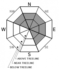
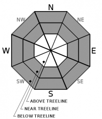
Blowing and drifting snow will deposit in lee areas forming unstable wind slabs above treeline and near treeline. Areas of unstable snow may form in wind protected areas near treeline and below treeline during the late day hours, possibly sooner. MODERATE avalanche danger exists above treeline and near treeline. LOW avalanche danger below treeline early this morning will increase to MODERATE danger as the day progresses.

2. Moderate

?

Above Treeline
Heightened avalanche conditions on specific terrain features. Evaluate snow and terrain carefully; identify features of concern.

2. Moderate

?

Near Treeline
Heightened avalanche conditions on specific terrain features. Evaluate snow and terrain carefully; identify features of concern.

2. Moderate

?

Below Treeline
Heightened avalanche conditions on specific terrain features. Evaluate snow and terrain carefully; identify features of concern.
    Heightened avalanche conditions on specific terrain features. Evaluate snow and terrain carefully; identify features of concern.
Avalanche Problem 1: Wind Slab
  • Type ?
  • Aspect/Elevation ?
  • Likelihood ?
    Certain
    Very Likely
    Likely
    Possible
    Unlikely
  • Size ?
    Historic
    Very Large
    Large
    Small

Strong to gale force SW winds blowing and drifting new and old snow in above treeline and near treeline terrain is expected to form cohesive slabs in lee areas. These wind slabs will be most prominent on wind loaded and cross loaded NW-N-NE-E-SE aspects. The depth of wind slabs and the potential size of avalanches will increase today and tonight. The expected avalanche size will increase from D1 to D2 during the day today.

Areas where drifting snow is depositing below cornices and cliff bands or where depositing into drifted pillows are suspect. Identify where wind slabs likely exist and move around them with caution.

Avalanche Problem 2: Storm Slab
  • Type ?
  • Aspect/Elevation ?
  • Likelihood ?
    Certain
    Very Likely
    Likely
    Possible
    Unlikely
  • Size ?
    Historic
    Very Large
    Large
    Small

Storm slabs failing at the old/new snow interface in wind protected areas near and below treeline will become possible either late this afternoon or tonight. Graupel and on some northerly aspects surface hoar at the old/new snow interface may allow for storm slab instability to begin to show once new snow amounts exceed about 4 inches. As new snow amounts increase more rapidly after 4 pm, storm slabs will become more of an issue. If the upper end of forecast snowfall amounts is reached earlier today, this avalanche problem will develop sooner. Expected avalanche size will start at D1 today, potentially increasing to D2 near sunset or later on tonight depending on snowfall rates.

Snow surface cracking created while breaking trail in wind protected areas below treeline is a sign of unstable storm slabs in the area.

recent observations

* No new deep slab avalanches have been reported in the past two days with snowpit data showing significant strength gains at the weak layer interface.

* Breakable to semi-supportable sun crusts at the old snow surface are widespread across most aspects with the exception being northerly aspects above about 7,600'.

* Graupel has been observed at the old/new snow interface for the start of this storm and may contribute to instability. On some northerly aspects, this graupel is also mixed with surface hoar creating the potential for an even more problematic weak layer at the old/new snow interface.

Weather and CURRENT CONDITIONS
weather summary

SW ridgetop winds have become strong to gale over the past 24 hours. Light to moderate snowfall is forecast to continue today, increasing in intensity late this afternoon or evening as cold front passage occurs. The primary period for new snow accumulation with this storm is expected from 4 pm today to 10 am tomorrow which could possibly bring the multiday storm total up to around 10 to 15 inches. Following cold front passage, winds are forecast to gradually decrease in speed but remain gusty. Maximum daytime air temperatures for tomorrow will be about 5 degrees colder than today, influenced by the cold front passage.

CONDITIONS ALONG THE SIERRA CREST BETWEEN 8200 FT. AND 9200 FT. IN THE LAST 24 HOURS
6am temperature: 19 to 26 deg. F.
Max. temperature: 24 to 33 deg. F.
Average ridgetop wind direction: SW
Average ridgetop wind speed: 50 mph
Maximum ridgetop wind gust: 97 mph
New snowfall: 1 to 3 inches
Total snow depth: 57 to 81 inches
Two-Day Mountain Weather Forecast Produced in partnership with the Reno NWS
For 7000 ft. to 8000 ft.
Tuesday Tuesday Night Wednesday
Weather: Cloudy. Snow likely. Snow levels below 7000 feet. Chance of precipitation is 65%. Cloudy. Snow in the evening, then snow likely after midnight. Snow levels below 7000 feet. Chance of precipitation is 85%. Cloudy. Snow showers likely. Snow levels below 7000 feet. Chance of precipitation is 70%.
Temperatures: 30 to 36. deg. F. 16 to 21. deg. F. 26 to 31. deg. F.
Mid Slope Winds: Southwest 15 to 25 mph with gusts to 55 mph. Southwest 15 to 25 mph. Gusts up to 45 mph decreasing to 30 mph after midnight. Southwest around 15 mph with gusts to 30 mph.
Expected snowfall: 70% probability of 2 to 5 inches. 30% probability of 1 to 2 inches. | SWE = up to 0.25 inch. 70% probability of 2 to 6 inches. 30% probability of 1 to 2 inches. | SWE = 0.15-0.40 inch. 70% probability up to 2 inches. 30% probability no accumulation. | SWE = up to 0.15 inch.
For 8000 ft. to 9000 ft.
Tuesday Tuesday Night Wednesday
Weather: Cloudy. Snow likely. Snow levels below 7000 feet. Chance of precipitation is 65%. Cloudy. Snow in the evening, then snow likely after midnight. Snow levels below 7000 feet. Chance of precipitation is 85%. Cloudy. Snow showers likely. Snow levels below 7000 feet. Chance of precipitation is 75%.
Temperatures: 25 to 31. deg. F. 13 to 18. deg. F. 21 to 27. deg. F.
Ridge Top Winds: Southwest 30 to 45 mph with gusts to 80 mph. Southwest 20 to 35 mph with gusts to 70 mph. Southwest 15 to 30 mph. Gusts up to 65 mph decreasing to 45 mph in the afternoon.
Expected snowfall: 70% probability of 2 to 5 inches. 30% probability of 1 to 3 inches. | SWE = up to 0.30 inch. 70% probability of 2 to 6 inches. 30% probability of 1 to 2 inches. | SWE = 0.20-0.45 inch. 70% probability up to 2 inches. 30% probability no accumulation. | SWE = up to 0.15 inch.
Disclaimer

This avalanche forecast is provided through a partnership between the Tahoe National Forest and the Sierra Avalanche Center. This forecast covers the Central Sierra Nevada Mountains between Yuba Pass on the north and Ebbetts Pass on the south. Click here for a map of the forecast area. This forecast applies only to backcountry areas outside established ski area boundaries. This forecast describes general avalanche conditions and local variations always occur. This forecast expires 24 hours after the posted time unless otherwise noted. The information in this forecast is provided by the USDA Forest Service who is solely responsible for its content.

For a recorded version of the avalanche forecast call (530) 587-3558 x258