THIS AVALANCHE FORECAST EXPIRED ON March 26, 2020 @ 6:51 am
Avalanche Forecast published on March 25, 2020 @ 6:51 am
Issued by Brandon Schwartz - Tahoe National Forest

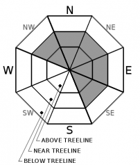
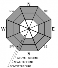
Wind drifted new snow has formed into dangerous wind slabs in above treeline and near treeline terrain. Unstable snow in the form of storm slab or loose dry avalanches may be encountered in wind protected areas below treeline. CONSIDERABLE avalanche danger exists above treeline and near treeline with MODERATE avalanche danger below treeline.

3. Considerable

?

Above Treeline
Dangerous avalanche conditions. Careful snowpack evaluation, cautious route-finding and conservative decision-making essential.

3. Considerable

?

Near Treeline
Dangerous avalanche conditions. Careful snowpack evaluation, cautious route-finding and conservative decision-making essential.

2. Moderate

?

Below Treeline
Heightened avalanche conditions on specific terrain features. Evaluate snow and terrain carefully; identify features of concern.
    Dangerous avalanche conditions. Careful snowpack evaluation, cautious route-finding and conservative decision-making essential.
Avalanche Problem 1: Wind Slab
  • Type ?
  • Aspect/Elevation ?
  • Likelihood ?
    Certain
    Very Likely
    Likely
    Possible
    Unlikely
  • Size ?
    Historic
    Very Large
    Large
    Small

Wind drifting new snow was observed forming into wind slabs yesterday in lee areas. These slabs will have increased in size last night and may now be 2 to 3+ feet thick. Dangerous, unstable slabs of wind drifted snow are expected today above treeline and near treeline mainly on wind loaded and cross loaded NW-N-NE-E-SE aspects. Avalanche size is expected at D2.

Identify areas where wind slabs exist and avoid them. Slopes on which wind drifted snow has deposited are suspect. Identify problematic areas with pillows of newly drifted snow, slopes below cornice features and cliff bands and route find around them. Conservative terrain selection is warranted.

Avalanche Problem 2: Storm Slab
  • Type ?
  • Aspect/Elevation ?
  • Likelihood ?
    Certain
    Very Likely
    Likely
    Possible
    Unlikely
  • Size ?
    Historic
    Very Large
    Large
    Small

Rapid new snow accumulation overnight with plenty of graupel mixed in has created the possibility of storm slabs in wind protected areas near and below treeline on all aspects. Some areas of surface hoar were reported pre storm on NW-N-NE aspects and may further contribute to instability if the surface hoar survived intact to burial at the old/new snow interface. In areas where storm slabs are not present, new snow may fail as loose dry avalanches, especially if poorly bonded to sun crust at the base of the new snow. Avalanche size is expected at D1 to D2.

Snow surface cracking created while breaking trail in wind protected areas below treeline is a sign of unstable storm slabs in the area. Use slope angle to manage areas of storm slab or loose dry instability.

recent observations

* Observations made yesterday on Andesite Peak (Donner Summit area) showed developing wind slabs in lee areas above treeline with minor skier triggered cracking. New cornice formation was observed along ridgetops. Periodic showers of graupel were noted.

* Reports of wind drifting snow were received from Rubicon Peak (West Shore Tahoe area) and from Echo Peak (Echo Summit area) in near treeline terrain. Significant amounts of graupel were noted within the new snow.

Weather and CURRENT CONDITIONS
weather summary

The storm system currently affecting the forecast area will slowly exit the region today and tomorrow. Snowfall rates peaked overnight with the cold front passage. Snow showers will linger today and tomorrow. Ridgetop winds are forecast to remain out of the SW today at moderate to strong in speed. Wind speeds are expected to further decrease tonight and become light in speed tomorrow. There is a slight chance of thunderstorms in the afternoon both today and tomorrow with lightning strikes possible. Friday is forecast to be cloudy and without precipitation. The next weather system to affect the region is expected on Saturday.

CONDITIONS ALONG THE SIERRA CREST BETWEEN 8200 FT. AND 9200 FT. IN THE LAST 24 HOURS
6am temperature: 14 to 21 deg. F.
Max. temperature: 21 to 30 deg. F.
Average ridgetop wind direction: SW
Average ridgetop wind speed: 52 mph
Maximum ridgetop wind gust: 107 mph
New snowfall: 7 to 11 inches
Total snow depth: 67 to 88 inches
Two-Day Mountain Weather Forecast Produced in partnership with the Reno NWS
For 7000 ft. to 8000 ft.
Wednesday Wednesday Night Thursday
Weather: Mostly cloudy. Chance of snow in the morning, then widespread snow showers and slight chance of thunderstorms in the afternoon. Snow levels below 7000 feet. Chance of precipitation is 60%. Mostly cloudy then becoming partly cloudy. Slight chance of thunderstorms in the evening. Scattered snow showers through the night. Snow levels below 7000 feet. Chance of precipitation is 30%. Partly cloudy then becoming mostly cloudy. Chance of snow showers throughout the day. Slight chance of thunderstorms in the afternoon. Snow levels below 7000 feet. Chance of precipitation is 50%.
Temperatures: 26 to 31. deg. F. 9 to 15. deg. F. 27 to 32. deg. F.
Mid Slope Winds: Southwest 15 to 20 mph with gusts to 45 mph. West around 15 mph with gusts to 45 mph in the evening becoming light. Light winds.
Expected snowfall: 80% probability up to 3 inches. 20% probability of 2 to 4 inches. | SWE = up to 0.15 inch. 40% probability up to 1 inch. 60% probability no accumulation. | SWE = less than 0.10 inch. 60% probability up to 1 inch. 40% probability no accumulation. | SWE = less than 0.10 inch.
For 8000 ft. to 9000 ft.
Wednesday Wednesday Night Thursday
Weather: Mostly cloudy. Snow likely in the morning, then widespread snow showers and slight chance of thunderstorms in the afternoon. Snow levels below 7000 feet. Chance of precipitation is 65%. Mostly cloudy then becoming partly cloudy. Slight chance of thunderstorms in the evening. Scattered snow showers through the night. Snow levels below 7000 feet. Chance of precipitation is 30%. Partly cloudy then becoming mostly cloudy. Snow showers likely throughout the day. Slight chance of thunderstorms in the afternoon. Snow levels below 7000 feet. Chance of precipitation is 55%.
Temperatures: 20 to 26. deg. F. 6 to 12. deg. F. 21 to 27. deg. F.
Ridge Top Winds: Southwest 15 to 25 mph. Gusts up to 50 mph decreasing to 40 mph in the afternoon. West 15 to 20 mph with gusts to 40 mph in the evening becoming light. Light winds.
Expected snowfall: 70% probability of 1 to 3 inches. 30% probability of 3 to 6 inches. | SWE = up to 0.15 inch. 40% probability up to 1 inch. 60% probability no accumulation. | SWE = less than 0.10 inch. 60% probability up to 1 inch. 40% probability no accumulation. | SWE = less than 0.10 inch.
Disclaimer

This avalanche forecast is provided through a partnership between the Tahoe National Forest and the Sierra Avalanche Center. This forecast covers the Central Sierra Nevada Mountains between Yuba Pass on the north and Ebbetts Pass on the south. Click here for a map of the forecast area. This forecast applies only to backcountry areas outside established ski area boundaries. This forecast describes general avalanche conditions and local variations always occur. This forecast expires 24 hours after the posted time unless otherwise noted. The information in this forecast is provided by the USDA Forest Service who is solely responsible for its content.

For a recorded version of the avalanche forecast call (530) 587-3558 x258