THIS AVALANCHE FORECAST EXPIRED ON March 27, 2020 @ 7:00 am
Avalanche Forecast published on March 26, 2020 @ 7:00 am
Issued by Steve Reynaud - Tahoe National Forest

Numerous avalanches were reported yesterday throughout the forecast region.  Human triggered avalanches will remain possible today due to wind slab and loose dry avalanche problems.  MODERATE avalanche danger will exist at all elevations.

2. Moderate

?

Above Treeline
Heightened avalanche conditions on specific terrain features. Evaluate snow and terrain carefully; identify features of concern.

2. Moderate

?

Near Treeline
Heightened avalanche conditions on specific terrain features. Evaluate snow and terrain carefully; identify features of concern.

2. Moderate

?

Below Treeline
Heightened avalanche conditions on specific terrain features. Evaluate snow and terrain carefully; identify features of concern.
    Heightened avalanche conditions on specific terrain features. Evaluate snow and terrain carefully; identify features of concern.
Avalanche Problem 1: Wind Slab
  • Type ?
  • Aspect/Elevation ?
  • Likelihood ?
    Certain
    Very Likely
    Likely
    Possible
    Unlikely
  • Size ?
    Historic
    Very Large
    Large
    Small

Reactive wind slab avalanches were reported throughout the forecast area yesterday.  These wind slabs could remain sensitive to human triggering today on NW-N-NE-E-SE aspects in near and above treeline areas.  Many of these wind slab avalanches were failing on weaknesses within the new storm snow and were around 1 to 2 feet deep.  Although, wind slabs were observed up to 3 feet deep in some areas with failure closer to the new snow/old snow interface.  SW winds decreased in speed last night after continued snow transport up to that point.  Winds are forecasted to remain light throughout today.

Look for previous signs of wind transport.  Large and fragile cornices have been built out above wind loaded slopes.  Wind slab avalanches could continue to propagate wide and efficiently.  Good snow quality will exist in below treeline areas away from the wind slab hazard. 

Avalanche Problem 2: Loose Dry
  • Type ?
  • Aspect/Elevation ?
  • Likelihood ?
    Certain
    Very Likely
    Likely
    Possible
    Unlikely
  • Size ?
    Historic
    Very Large
    Large
    Small

Continued cold temperatures, light winds, and additional low density snowfall will continue to make loose dry avalanches possible.  Loose dry sluffing could occur on all aspects in wind protected below treeline and near treeline areas.  These loose dry avalanches are expected to be mostly small in size and occur on slopes steeper than 35 degrees.  The main hazard with this loose dry sluffing would be secondary exposure-taking a ride or being pushed into trees, rocks, or over cliffs.    

recent observations

Wind slab avalanches were reported yesterday from Andesite Peak, Deep Creek , Powderhouse Peak, Mt. Tallac, and Muchkins in the Five Lakes area.  All of these were human triggered wind slab avalanches and varied from 1 to 3' deep.

An avalanche was reported from the Cabin Creek area with limited details.  Reports indicate that a skier triggered wind slab avalanche may have stepped down to a deeper weak layer causing a much larger avalanche.  No one was caught.

Loose dry sluffing was reported throughout the forecast region with low density storm snow.  The storm snow was made up of several different layers of graupel.  No reports of buried surface hoar under this storm snow at this point.  

Weather and CURRENT CONDITIONS
weather summary

8 to 15'' of storm snow has fallen on the Sierra Crest over the last 2 days.  Moderate to strong SW winds decreased to light last night and are forecasted to remain light through today.  Cold and cloudy conditions will continue with scattered snow showers expected.  Generally light snow is forecasted with up to 1 to 3'' of snow.  Isolated thunderstorms are also possible this afternoon.  Friday should clear and slightly warm, then chances of light snow and unsettled weather returns for the weekend.

CONDITIONS ALONG THE SIERRA CREST BETWEEN 8200 FT. AND 9200 FT. IN THE LAST 24 HOURS
6am temperature: 7 to 15 deg. F.
Max. temperature: 19 to 28 deg. F.
Average ridgetop wind direction: SW
Average ridgetop wind speed: 25 to 40 becoming light mph
Maximum ridgetop wind gust: 52 mph
New snowfall: 1 to 3 inches
Total snow depth: 70 to 89 inches
Two-Day Mountain Weather Forecast Produced in partnership with the Reno NWS
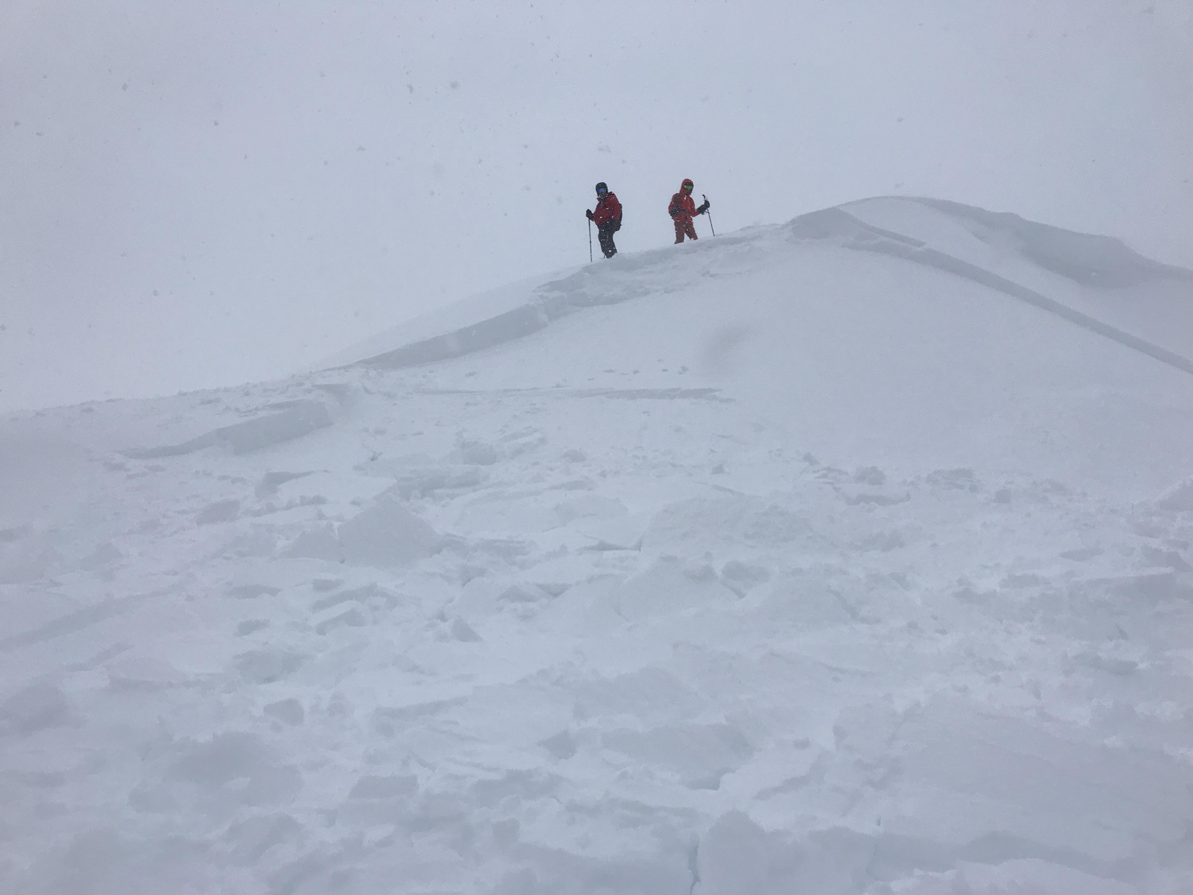
For 7000 ft. to 8000 ft.
Thursday Thursday Night Friday
Weather: Partly cloudy then becoming mostly cloudy. Scattered snow showers through the day. Slight chance of thunderstorms in the afternoon. Snow levels below 7000 feet. Chance of precipitation is 50%. Partly cloudy then becoming clear. Slight chance of thunderstorms and isolated snow showers in the evening. Snow levels below 7000 feet. Chance of precipitation is 20%. Sunny then becoming partly cloudy. Snow levels below 7000 feet. Chance of precipitation is 0%.
Temperatures: 26 to 31. deg. F. 11 to 17. deg. F. 33 to 38. deg. F.
Mid Slope Winds: Light winds. Light winds. Light winds.
Expected snowfall: 60% probability of 1 to 3 inches. 40% probability up to 1 inch. | SWE = less than 0.10 inch. Up to 1 inch. | SWE = less than 0.10 inch. No accumulation. | SWE = none.
For 8000 ft. to 9000 ft.
Thursday Thursday Night Friday
Weather: Mostly cloudy. Isolated snow showers in the morning, then widespread snow showers and slight chance of thunderstorms in the afternoon. Snow levels below 7000 feet. Chance of precipitation is 55%. Mostly cloudy then becoming clear. Slight chance of thunderstorms and isolated snow showers in the evening. Snow levels below 7000 feet. Chance of precipitation is 25%. Sunny then becoming partly cloudy. Snow levels below 7000 feet. Chance of precipitation is 0%.
Temperatures: 20 to 26. deg. F. 8 to 14. deg. F. 28 to 34. deg. F.
Ridge Top Winds: Light winds. North around 15 mph. Gusts up to 25 mph in the evening. West around 15 mph with gusts to 30 mph.
Expected snowfall: 80% probability of 1 to 3 inches. 20% probability up to 1 inch. | SWE = up to 0.15 inch. Up to 1 inch. | SWE = less than 0.10 inch. No accumulation. | SWE = none.
Disclaimer

This avalanche forecast is provided through a partnership between the Tahoe National Forest and the Sierra Avalanche Center. This forecast covers the Central Sierra Nevada Mountains between Yuba Pass on the north and Ebbetts Pass on the south. Click here for a map of the forecast area. This forecast applies only to backcountry areas outside established ski area boundaries. This forecast describes general avalanche conditions and local variations always occur. This forecast expires 24 hours after the posted time unless otherwise noted. The information in this forecast is provided by the USDA Forest Service who is solely responsible for its content.

For a recorded version of the avalanche forecast call (530) 587-3558 x258