THIS AVALANCHE FORECAST EXPIRED ON March 30, 2020 @ 7:00 am
Avalanche Forecast published on March 29, 2020 @ 7:00 am
Issued by Andy Anderson - Tahoe National Forest - Sierra Avalanche Center

Slab avalanches 1 to 3 ft deep that break on a weak layer of buried surface hoar remain possible at all elevations today. New snow and wind may also form fresh slabs of wind drifted snow in some areas. These wind slabs could step down to break on the persistent weak layer. Choosing conservative terrain can help avoid getting caught by a persistent slab problem that is unusual for this area. MODERATE avalanche danger will continue.

2. Moderate

?

Above Treeline
Heightened avalanche conditions on specific terrain features. Evaluate snow and terrain carefully; identify features of concern.

2. Moderate

?

Near Treeline
Heightened avalanche conditions on specific terrain features. Evaluate snow and terrain carefully; identify features of concern.

2. Moderate

?

Below Treeline
Heightened avalanche conditions on specific terrain features. Evaluate snow and terrain carefully; identify features of concern.
    Heightened avalanche conditions on specific terrain features. Evaluate snow and terrain carefully; identify features of concern.
Avalanche Problem 1: Persistent Slab
  • Type ?
  • Aspect/Elevation ?
  • Likelihood ?
    Certain
    Very Likely
    Likely
    Possible
    Unlikely
  • Size ?
    Historic
    Very Large
    Large
    Small

While no new avalanches were reported to have occurred yesterday, people have triggered persistent slab avalanches every other day since March 25. New snow will not help solve this problem. Slab avalanches that fail on weak snow (surface hoar on top of a thin crust) buried below the recent snow still remain possible today. In sheltered areas, people have triggered avalanches about 1 ft deep. In more exposed areas where slabs of wind drifted snow exist above this layer, the avalanches have measured 2 to 3 feet in depth. These avalanches have propagated long distances across slopes and wrapped around terrain features. In some cases, people triggered them from a distance while traveling in lower angle terrain connected to steeper slopes.

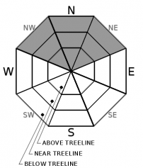
Open areas on NW-N-NE aspects at all elevations represent the most likely places to find this persistent slab problem. Avalanches could fail mid-slope or at the top of a slope. They could break above or behind the person who triggers them with very wide propagation or be remotely triggered. Identify slopes where persistent slabs could exist. Manage your aspects and slope angles carefully and be careful with terrain to connected to steeper slopes. 

Plenty of great snow exists on lower angle more sheltered terrain. Choosing these areas will help find excellent recreation conditions and avoid potential wind slab or persistent slab avalanches.

Avalanche Problem 2: Wind Slab
  • Type ?
  • Aspect/Elevation ?
  • Likelihood ?
    Certain
    Very Likely
    Likely
    Possible
    Unlikely
  • Size ?
    Historic
    Very Large
    Large
    Small

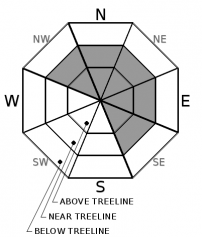
Unstable slabs of wind drifted snow may also still linger on wind-loaded and cross-loaded NW-N-NE-E-SE aspects. New snow and wind last night and today will create new wind slabs near some ridgelines. These fresh wind slabs should remain small in most places. They should also be easier to trigger and could step down to the buried surface hoar or graupel layer. In those cases, they would behave as the persistent slabs mentioned above. Human triggered wind slab avalanches remain possible today.

Look for built out cornices, wind pillows, and steep wind loaded terrain where unstable wind slabs are most likely to exist. Wind slab avalanches have been propagating wider than normal. Avoid areas below large cornices and wind loaded slopes.

recent observations

No new avalanches were reported yesterday, but more reports of previous activity came in in the form of skier triggered avalanches on Tallac on Friday and snowmobiler avalanches above Frog Lake near Castle Peak on Thursday. Both of these avalanches failed at the base of the recent snow about 1 ft below the surface where buried surface hoar and graupel have been observed on top of a thin crust.

Observations from upper elevations on Tallac yesterday did not find as many signs of instability.

In the Mt. Rose backcountry yesterday, observations revealed less recent snow and less of a crust at the base of the recent snow. Tests targeting this interface provided variable results with fewer signs of instability. No persistent slab avalanches had been reported in the Mt. Rose area.

Observers continue to report soft cold snow on northerly aspects. In areas exposed to sunshine, breakable crusts existed with wet sticky snow forming on some sun-exposed southerly aspects yesterday. 

Weather and CURRENT CONDITIONS
weather summary

Winds increased along ridgetops last night and grew strong enough to transport snow in some places. 2 to 4 inches of new snow also accumulated during the night. Snow and light SW winds should continue today with another 1 to 3 inches expected above 7000 ft. Some of the winds could be stronger along the upper elevation ridgelines. The storm should taper off this evening and a warming trend with increased winds should begin tomorrow. 

CONDITIONS ALONG THE SIERRA CREST BETWEEN 8200 FT. AND 9200 FT. IN THE LAST 24 HOURS
6am temperature: 19 to 26 deg. F.
Max. temperature: 28 to 35 deg. F.
Average ridgetop wind direction: SW
Average ridgetop wind speed: 15 to 25 mph
Maximum ridgetop wind gust: 37 mph
New snowfall: 2 to 4 inches
Total snow depth: 62 to 84 inches
Two-Day Mountain Weather Forecast Produced in partnership with the Reno NWS
For 7000 ft. to 8000 ft.
Sunday Sunday Night Monday
Weather: Mostly cloudy. Scattered snow showers in the morning, then snow showers likely in the afternoon. Snow levels below 7000 feet. Chance of precipitation is 65%. Mostly cloudy then becoming partly cloudy. Isolated snow showers in the evening. Snow levels below 7000 feet. Chance of precipitation is 20%. Partly cloudy. Snow levels below 7000 feet. Chance of precipitation is 5%.
Temperatures: 33 to 38 deg. F. 20 to 25 deg. F. 39 to 45 deg. F.
Mid Slope Winds: Light winds becoming southwest around 15 mph in the afternoon. Southwest around 15 mph with gusts to 25 mph. Southwest 15 to 20 mph with gusts to 35 mph.
Expected snowfall: 90% probability of 1 to 3 inches. 10% probability of 3 to 4 inches. | SWE = up to 0.15 inch. Up to 1 inch. | SWE = less than 0.10 inch. No accumulation. | SWE = none.
For 8000 ft. to 9000 ft.
Sunday Sunday Night Monday
Weather: Mostly cloudy. Scattered snow showers in the morning, then snow showers likely in the afternoon. Snow levels below 7000 feet. Chance of precipitation is 65%. Mostly cloudy then becoming partly cloudy. Isolated snow showers in the evening. Snow levels below 7000 feet. Chance of precipitation is 20%. Partly cloudy. Snow levels below 7000 feet. Chance of precipitation is 5%.
Temperatures: 27 to 33 deg. F. 17 to 22 deg. F. 35 to 41 deg. F.
Ridge Top Winds: Southwest around 15 mph with gusts to 25 mph. Southwest around 15 mph with gusts to 35 mph. Southwest 20 to 30 mph with gusts to 60 mph.
Expected snowfall: 80% probability of 1 to 3 inches. 20% probability of 3 to 4 inches. | SWE = up to 0.15 inch. Up to 1 inch. | SWE = less than 0.10 inch. No accumulation. | SWE = none.
Disclaimer

This avalanche forecast is provided through a partnership between the Tahoe National Forest and the Sierra Avalanche Center. This forecast covers the Central Sierra Nevada Mountains between Yuba Pass on the north and Ebbetts Pass on the south. Click here for a map of the forecast area. This forecast applies only to backcountry areas outside established ski area boundaries. This forecast describes general avalanche conditions and local variations always occur. This forecast expires 24 hours after the posted time unless otherwise noted. The information in this forecast is provided by the USDA Forest Service who is solely responsible for its content.

For a recorded version of the avalanche forecast call (530) 587-3558 x258